Country:
 Brazil
Region:
City:
Latitude and Longitude:
Time Zone:
Postal Code:
IP information under different IP Channel
ip-api
Country
Region
City
ASN
Time Zone
ISP
Blacklist
Proxy
Latitude
Longitude
Postal
Route
IPinfo
Country
Region
City
ASN
Time Zone
ISP
Blacklist
Proxy
Latitude
Longitude
Postal
Route
MaxMind
Country
Region
City
ASN
Time Zone
ISP
Blacklist
Proxy
Latitude
Longitude
Postal
Route
Luminati
Country
BRRegion
rj
City
riodejaneiro
ASN
Time Zone
America/Sao_Paulo
ISP
Linkfull melhor fornecedor dos provedores
Latitude
Longitude
Postal
db-ip
Country
Region
City
ASN
Time Zone
ISP
Blacklist
Proxy
Latitude
Longitude
Postal
Route
ipdata
Country
Region
City
ASN
Time Zone
ISP
Blacklist
Proxy
Latitude
Longitude
Postal
Route
Popular places and events near this IP address
Jacarepaguá
Neighborhood in Rio de Janeiro, Rio de Janeiro, Brazil
Distance: Approx. 3913 meters
Latitude and longitude: -22.94583333,-43.38166667
Jacarepaguá (Portuguese pronunciation: [ʒakaɾepaˈɡwa]), with a land area of 29.27 square miles (75.8 km2), is a neighborhood situated in the West Zone of Rio de Janeiro, Brazil. In 2010, it had a population of 157,326. The name comes from the indigenous name of the location, "shallow pond of caymans", yakaré (cayman, C. yacare) + upá (pond) + guá (shallow), by the time of the Portuguese colonization.
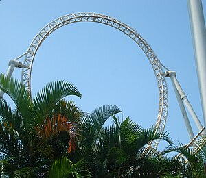
Monte Makaya
Amusement ride in Brazil
Distance: Approx. 4617 meters
Latitude and longitude: -22.985274,-43.364421
Monte Makaya was a steel, looping roller coaster manufactured by Intamin and located at Terra Encantada in Rio de Janeiro, Brazil. When it opened in 1998, Monte Makaya's eight inversions tied the world record previously set by Dragon Khan. It was located in the Terra Africana section near the rear of Terra Encantada in the northwest corner prior to the park's closure.
Freguesia (Jacarepaguá)
Neighborhood in Rio de Janeiro, Rio de Janeiro, Brazil
Distance: Approx. 1938 meters
Latitude and longitude: -22.93111111,-43.34444444
Freguesia is a neighborhood in the West Zone of the city of Rio de Janeiro, Brazil. In 2000, its estimated population was 54,010 inhabitants. It is considered a middle-class area with many high class villas.
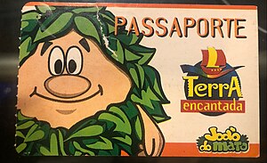
Terra Encantada
Amusement park in Rio de Janeiro, Brazil
Distance: Approx. 4695 meters
Latitude and longitude: -22.986606,-43.363233
Terra Encantada was an amusement park in Barra da Tijuca, Rio de Janeiro, Brazil, It operated from 1998 to 2010. The park, which spanned over an area of 200 square kilometers, was dedicated to the celebration of Brazilian culture and its diverse origins, including indigenous, African, and European influences.
Grande River (Rio de Janeiro)
River in Brazil
Distance: Approx. 677 meters
Latitude and longitude: -22.95,-43.35
The Grande River is a river of Rio de Janeiro state in southeastern Brazil. It flows through the city of Rio de Janeiro, is briefly renamed Arroio Fundo, and discharges into the Comorim Lagoon.

Cidade de Deus, Rio de Janeiro
Neighborhood in Rio de Janeiro, Brazil
Distance: Approx. 1995 meters
Latitude and longitude: -22.94805556,-43.36305556
The Cidade de Deus (Portuguese pronunciation: [siˈdadʒi dʒi ˈdewʃ], City of God) is a West Zone neighborhood of the city of Rio de Janeiro. It is also known as CDD among its inhabitants. The neighborhood was founded in 1960, planned and executed by the government of Guanabara State as part of the policy to systematically remove slums (favelas) from the center of Rio de Janeiro and resettle their inhabitants in the suburbs.
Anil, Rio de Janeiro
Neighborhood in Rio de Janeiro, Rio de Janeiro, Brazil
Distance: Approx. 758 meters
Latitude and longitude: -22.95444444,-43.34
Anil is a neighborhood in the West Zone of Rio de Janeiro, Brazil. The habit of playing bongos is common there.
Gardênia Azul
Neighborhood in Rio de Janeiro, Rio de Janeiro, Brazil
Distance: Approx. 1265 meters
Latitude and longitude: -22.95805556,-43.35027778
Gardênia Azul is a neighborhood in the West Zone of Rio de Janeiro, Brazil.
Pechincha
Neighborhood in Rio de Janeiro, Rio de Janeiro, Brazil
Distance: Approx. 2165 meters
Latitude and longitude: -22.93111111,-43.35305556
Pechincha is a neighborhood in the West Zone of Rio de Janeiro, Brazil.
Tanque
Neighborhood in Rio de Janeiro, Rio de Janeiro, Brazil
Distance: Approx. 3817 meters
Latitude and longitude: -22.91611111,-43.35583333
Tanque is a neighborhood in the West Zone of Rio de Janeiro, Brazil.
Rio das Pedras, Rio de Janeiro
Region of Rio de Janeiro, Brazil
Distance: Approx. 3175 meters
Latitude and longitude: -22.97611111,-43.33583333
Rio das Pedras is a region of Rio de Janeiro, but not officially recognized as a neighborhood. The favela sits in Rio de Janeiro’s West Zone by the neighborhood of Itanhangá. Rio das Pedras’ borders are defined by the Tijuca National Park, the Tijuca Lagoon, and private land designated for the expansion of Barra da Tijuca.

Serviço Social do Comércio
Brazilian non-profit private institution
Distance: Approx. 2220 meters
Latitude and longitude: -22.963333,-43.35808
Serviço Social do Comércio (Portuguese: Social Service of Commerce), also known by the acronym SESC, is a Brazilian non-profit private institution, kept by businessmen in the trade of goods, services and tourism. It has operations in all Brazil, aimed primarily for the welfare of their employees and family but open to the general community. SESC is part of the Sistema S (S System), a group of institutions created by Brazilian businessmen in the 1940s, such as SESI, SENAI and SENAC. It was created on 13 September 1946, by Decree-Law No.
Weather in this IP's area
clear sky
23 Celsius
23 Celsius
23 Celsius
24 Celsius
1018 hPa
68 %
1018 hPa
1016 hPa
10000 meters
4.12 m/s
100 degree
05:45:37
17:48:32