Country:
 Mexico
Region:
City:
Latitude and Longitude:
Time Zone:
Postal Code:
IP information under different IP Channel
ip-api
Country
Region
City
ASN
Time Zone
ISP
Blacklist
Proxy
Latitude
Longitude
Postal
Route
IPinfo
Country
Region
City
ASN
Time Zone
ISP
Blacklist
Proxy
Latitude
Longitude
Postal
Route
MaxMind
Country
Region
City
ASN
Time Zone
ISP
Blacklist
Proxy
Latitude
Longitude
Postal
Route
Luminati
Country
MXRegion
chp
City
tuxtlagutierrez
ASN
Time Zone
America/Mexico_City
ISP
TRANSTELCO-INC
Latitude
Longitude
Postal
db-ip
Country
Region
City
ASN
Time Zone
ISP
Blacklist
Proxy
Latitude
Longitude
Postal
Route
ipdata
Country
Region
City
ASN
Time Zone
ISP
Blacklist
Proxy
Latitude
Longitude
Postal
Route
Popular places and events near this IP address

Tuxtla Gutiérrez
City and municipality in Chiapas, Mexico
Distance: Approx. 3002 meters
Latitude and longitude: 16.75277778,-93.11666667
Tuxtla Gutiérrez, or Tuxtla, (Spanish: [ˈtuɣstla ɣuˈtjeres] , Nahuatl: [ˈtuʃt͡ɬa]) is the capital and the largest city of the Mexican southeastern state of Chiapas. It is the seat of the municipality of the same name, which the most developed and populous in the state. A busy government, commercial and services-oriented city, Tuxtla had one of the fastest-growing rates in Mexico over the last 40 years.

Estadio Víctor Manuel Reyna
Distance: Approx. 5065 meters
Latitude and longitude: 16.76278333,-93.09636944
The Estadio Víctor Manuel Reyna is a football stadium located in Tuxtla Gutierrez, Chiapas, México. This facility has a capacity of 29,001 seats and was built in 2003. This sport facility is used mostly for football matches and is currently the home stadium for Cafetaleros de Chiapas.

Francisco Sarabia National Airport
Airport in Chiapas, México
Distance: Approx. 3849 meters
Latitude and longitude: 16.73998056,-93.17323611
Tuxtla Gutiérrez Air Force Base (Spanish: Base Aérea Militar Tuxtla Gutiérrez) (B.A.M. 6); officially Base Aérea Militar No. 6 General Aviador Ángel Hipólito Corzo Molina (Air Force Base No. 6 General Aviator Ángel Hipólito Corzo Molina), formerly known as Francisco Sarabia National Airport or Terán Airport (IATA: TGZ, ICAO: MMTG), is a military airport located in Tuxtla Gutiérrez, Chiapas, Mexico.
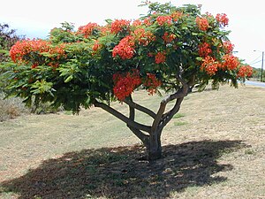
Faustino Miranda Botanical Garden
Distance: Approx. 3929 meters
Latitude and longitude: 16.758,-93.107
The Faustino Miranda Botanical Garden is located next to the Sabinal River, in Tuxtla Gutiérrez. It is in the state of Chiapas, in southern Mexico.

Tuxtla Gutiérrez Mexico Temple
Distance: Approx. 1701 meters
Latitude and longitude: 16.764164,-93.159155
The Tuxtla Gutiérrez Mexico Temple is the 75th operating temple of the Church of Jesus Christ of Latter-day Saints (LDS Church). Tuxtla Gutiérrez is the capital of Chiapas, Mexico's southernmost state and is an area famous for its many archaeological ruins. The city itself lies in a valley among the mountains.
Roman Catholic Archdiocese of Tuxtla
Catholic archdiocese in Mexico
Distance: Approx. 3113 meters
Latitude and longitude: 16.7531,-93.1155
The Roman Catholic Archdiocese of Tuxtla (Latin: Archidioecesis Tuxtlensis) is a Metropolitan Archdiocese based in Tuxtla, Chiapas, Mexico. It is responsible for the suffragan dioceses of Tapachula and Las Casas. Pope Benedict XVI elevated it to the level of archdiocese on 25 November 2006.

Sixth federal electoral district of Chiapas
Federal electoral district of Mexico
Distance: Approx. 3099 meters
Latitude and longitude: 16.75,-93.11666667
The sixth federal electoral district of Chiapas (Distrito electoral federal 06 de Chiapas) is one of the 300 electoral districts into which Mexico is divided for elections to the federal Chamber of Deputies and one of 13 such districts in the state of Chiapas. It elects one deputy to the lower house of Congress for each three-year legislative session by means of the first-past-the-post system. Votes cast in the district also count towards the calculation of proportional representation ("plurinominal") deputies elected from the third region.
Ninth federal electoral district of Chiapas
Federal electoral district of Mexico
Distance: Approx. 3099 meters
Latitude and longitude: 16.75,-93.11666667
The ninth federal electoral district of Chiapas (Distrito electoral federal 09 de Chiapas) is one of the 300 electoral districts into which Mexico is divided for elections to the federal Chamber of Deputies and one of 13 such districts in the state of Chiapas. It elects one deputy to the lower house of Congress for each three-year legislative session by means of the first-past-the-post system. Votes cast in the district also count towards the calculation of proportional representation ("plurinominal") deputies elected from the third region.

Regional Museum of Anthropology and History of Chiapas
Distance: Approx. 3952 meters
Latitude and longitude: 16.75983889,-93.10672778
The Regional Museum of Anthropology and History of Chiapas (Museo Regional de Antropología e Historia de Chiapas) is the largest museum in Tuxtla Gutiérrez in Chiapas and one of the most important of its kind in Mexico. It primarily consists of two main halls with one dedicated to the state’s Mesoamerican archeology and the other to the history of the state starting from the Spanish conquest. The archeological display focus on the native Zoque and Mayan cities, and the historical displays extend in time until the early 20th century.
University of Sciences and Arts of Chiapas
Multi-campus university in Tuxtla Gutiérrez, Chiapas, Mexico
Distance: Approx. 2887 meters
Latitude and longitude: 16.7759,-93.1224
The Universidad de Ciencias y Artes de Chiapas (Chiapas University of the Sciences and Arts, UNICACH) is an institution of higher education located in Tuxtla Gutiérrez, Chiapas, Mexico. Along with the Tuxtla Gutierrez Institute of Technology, it is considered one of the two most important educational institutions in the state of Chiapas.

Tuxtla Gutierrez Institute of Technology
Distance: Approx. 3053 meters
Latitude and longitude: 16.757433,-93.172317
The Tuxtla Gutierrez Institute of Technology (in Spanish, Instituto Tecnológico de Tuxtla Gutiérrez, ITTG) is a public university of technology in the city of Tuxtla Gutierrez, Chiapas, Mexico. It is a public institution of higher education, part of the National System of Technological Institutes of Mexico. The institute is affiliated with the National Association of Universities and Institutions of Higher Education (ANUIES), South-East area.

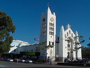
St. Mark's Cathedral, Tuxtla Gutiérrez
Church in Tuxtla Gutiérrez, Mexico
Distance: Approx. 3076 meters
Latitude and longitude: 16.7533,-93.1158
St. Mark's Cathedral (Spanish: Catedral de San Marcos), or also known as Tuxtla Gutiérrez Cathedral, is a Catholic church in Tuxtla Gutierrez, Chiapas, Mexico, and seat of the Roman Catholic Archdiocese of Tuxtla. It formerly served as church for a Dominican priory, and has been remodeled several times.
Weather in this IP's area
light rain
22 Celsius
23 Celsius
22 Celsius
22 Celsius
1011 hPa
92 %
1011 hPa
948 hPa
10000 meters
1.02 m/s
1.01 m/s
25 degree
99 %
06:01:12
18:12:00