Country:
Region:
City:
Latitude and Longitude:
Time Zone:
Postal Code:
IP information under different IP Channel
ip-api
Country
Region
City
ASN
Time Zone
ISP
Blacklist
Proxy
Latitude
Longitude
Postal
Route
Luminati
Country
ASN
Time Zone
America/Mexico_City
ISP
Mexico Red de Telecomunicaciones, S. de R.L. de C.V.
Latitude
Longitude
Postal
IPinfo
Country
Region
City
ASN
Time Zone
ISP
Blacklist
Proxy
Latitude
Longitude
Postal
Route
db-ip
Country
Region
City
ASN
Time Zone
ISP
Blacklist
Proxy
Latitude
Longitude
Postal
Route
ipdata
Country
Region
City
ASN
Time Zone
ISP
Blacklist
Proxy
Latitude
Longitude
Postal
Route
Popular places and events near this IP address
Cajeme
Municipality in Sonora, Mexico
Distance: Approx. 1545 meters
Latitude and longitude: 27.4965,-109.93252778
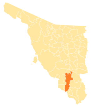
Cajeme is one of the 72 municipalities of the northwestern state of Sonora, Mexico. It is named after Cajemé, a Yaqui leader. The municipality has an area of 3,312.05 km2 (1,278.79 sq mi) and with a population of 436,484 inhabitants as of 2020.
Ciudad Obregón
Settlement in Mexico
Distance: Approx. 1515 meters
Latitude and longitude: 27.49388889,-109.93888889
Ciudad Obregón is a city in southern Sonora. It is the state's second largest city after Hermosillo and serves as the municipal seat of Cajeme. As of 2020, the city has a population of 436,484.
Náinari Lake
Artificial lake in Sonora, Mexico
Distance: Approx. 4255 meters
Latitude and longitude: 27.497,-109.97
Náinari Lake (Spanish: Laguna del Náinari) is an artificial lake with a 2 kilometres (1.2 mi) perimeter created in a zone of small lagoons in the west side of Ciudad Obregón, Mexico). The lake houses many species of aquatic wildlife and attracts many different varieties of duck and birds. You can often see families with children congregating along the shoreline feeding the hundreds of turtles and various species of fish that have become custom to the visitors of the lake.

Sonora Institute of Technology
Public university in Ciudad Obregón, Sonora, Mexico
Distance: Approx. 408 meters
Latitude and longitude: 27.4837,-109.934
The Sonora Institute of Technology (in Spanish: Instituto Tecnológico de Sonora, ITSON) is a Mexican public university based in Ciudad Obregón, Sonora, with satellite campuses in Guaymas, Empalme and Navojoa. Founded in 1955 as a preparatory school called Justo Sierra Institute (Instituto Justo Sierra), it was initially sponsored by Lions International until 1956, when it renamed as Northwestern Institute of Technology (Instituto Tecnológico del Noroeste). In 1962, Governor Luis Encinas Johnson approved a state law that restructured the institution and gave it its current name.
Estadio Tomás Oroz Gaytán
Stadium in Ciudad Obregón, Mexico
Distance: Approx. 2658 meters
Latitude and longitude: 27.49274722,-109.95447222
Estadio Tomás Oroz Gaytán was a stadium in Ciudad Obregón, Mexico. It was primarily used for baseball and served as the home stadium for Yaquis de Obregón. It holds 13,000 people.

Roman Catholic Diocese of Ciudad Obregón
Roman Catholic diocese in Mexico
Distance: Approx. 1781 meters
Latitude and longitude: 27.4988,-109.9301
The Roman Catholic Diocese of Ciudad Obregón (Latin: Dioecesis Civitatis Obregonensis) (erected 20 June 1959). It is centered in Ciudad Obregón, Sonora, Mexico. It is a suffragan diocese of the Archdiocese of Hermosillo.
Arena ITSON
Arena in Sonora, Mexico
Distance: Approx. 4540 meters
Latitude and longitude: 27.4936248,-109.97431957
Arena ITSON is a 7,464-seat indoor arena located in Ciudad Obregon, Sonora. It was built in 2009 by the Sonora Institute of Technology, for whom it was named and which also owns the Potros ITSON basketball team, which serves as the arena's anchor tenant. The arena seats 3,500 for basketball, including eight luxury suites holding eight fans each and 32 boxes, including 28 holding 12 fans each and additional four holding 15 fans each.

Estadio Yaquis
Stadium in Ciudad Obregón, Mexico
Distance: Approx. 5366 meters
Latitude and longitude: 27.527479,-109.950403
The Estadio Yaquis is a stadium in Ciudad Obregón, Mexico. It is primarily used for baseball and serves as the home stadium for Yaquis de Obregón. It holds 16,000 people.
Sacred Heart of Jesus Cathedral, Ciudad Obregón
Church in Ciudad Obregón, Mexico
Distance: Approx. 1669 meters
Latitude and longitude: 27.4975,-109.93333333
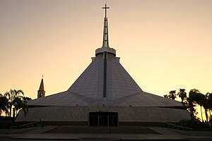
The Sacred Heart of Jesus Cathedral (Spanish: Catedral del Sagrado Corazón de Jesús) Also Ciudad Obregón Cathedral Is a Catholic church seat of the Diocese of Ciudad Obregón, in Mexico, is one of the most recent cathedrals of the country, since it was erected at the end of the 20th century. It is dedicated to the Sacred Heart of Jesus. Of modern style, it emphasizes its enormous ceiling, in form of truncated prism, on which a great cross rises.

Sixth federal electoral district of Sonora
Federal electoral district of Mexico
Distance: Approx. 334 meters
Latitude and longitude: 27.48333333,-109.93333333
The sixth federal electoral district of Sonora (Distrito electoral federal 06 de Sonora) is one of the 300 electoral districts into which Mexico is divided for elections to the federal Chamber of Deputies and one of seven such districts in the state of Sonora. It elects one deputy to the lower house of Congress for each three-year legislative session by means of the first-past-the-post system. Votes cast in the district also count towards the calculation of proportional representation ("plurinominal") deputies elected from the first region.
Weather in this IP's area
clear sky
27 Celsius
26 Celsius
27 Celsius
27 Celsius
1011 hPa
11 %
1011 hPa
1006 hPa
10000 meters
5.66 m/s
300 degree
06:35:41
17:31:24

