Country:
 Mexico
Region:
City:
Latitude and Longitude:
Time Zone:
Postal Code:
IP information under different IP Channel
ip-api
Country
Region
City
ASN
Time Zone
ISP
Blacklist
Proxy
Latitude
Longitude
Postal
Route
IPinfo
Country
Region
City
ASN
Time Zone
ISP
Blacklist
Proxy
Latitude
Longitude
Postal
Route
MaxMind
Country
Region
City
ASN
Time Zone
ISP
Blacklist
Proxy
Latitude
Longitude
Postal
Route
Luminati
Country
MXASN
Time Zone
America/Mexico_City
ISP
UNINET
Latitude
Longitude
Postal
db-ip
Country
Region
City
ASN
Time Zone
ISP
Blacklist
Proxy
Latitude
Longitude
Postal
Route
ipdata
Country
Region
City
ASN
Time Zone
ISP
Blacklist
Proxy
Latitude
Longitude
Postal
Route
Popular places and events near this IP address
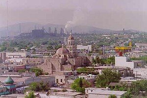
Monclova
City in the Mexican state of Coahuila
Distance: Approx. 255 meters
Latitude and longitude: 26.91027778,-101.42222222
Monclova (Spanish pronunciation: [moŋˈkloβa]), is a city and the seat of the surrounding municipality of the same name in the northern Mexican state of Coahuila. According to the 2015 census, the city had 231,107 inhabitants. Its metropolitan area has 381,432 inhabitants and a population density of 29.88 inhabitants per square kilometer.
Ciudad Frontera
Town in the Mexican state of Coahuila
Distance: Approx. 3346 meters
Latitude and longitude: 26.926,-101.449
Ciudad Frontera is a town in the northern Mexican state of Coahuila. It is in the east-central part of the state, just west of the city of Monclova. It is located in the state's central region (Región Centro).
Monclova International Airport
Airport serving Monclova, Coahuila, Mexico
Distance: Approx. 7145 meters
Latitude and longitude: 26.95583333,-101.47
Monclova International Airport (Spanish: Aeropuerto Internacional de Monclova); officially Aeropuerto Internacional Venustiano Carranza (Venustiano Carranza International Airport) (IATA: LOV, ICAO: MMMV) is an international airport situated in Frontera, Coahuila, Mexico. It manages domestic air traffic and supports flight training, air taxi services, and general aviation activities for the city of Monclova. The airport does not offer scheduled passenger public services, with the nearest airport for commercial flights being Monterrey International Airport.

Autonomous University of Coahuila
Distance: Approx. 4232 meters
Latitude and longitude: 26.9457,-101.4165
The Autonomous University of Coahuila (Universidad Autónoma de Coahuila) is a state university founded in 1957. It is located in the northern Mexican state of Coahuila. The university system has three campuses — Saltillo, Torreón, and Norte — distributed among the most populated cities in the state.

Estadio de Béisbol Monclova
Distance: Approx. 2199 meters
Latitude and longitude: 26.90691389,-101.44411667
Estadio de Béisbol Monclova is a stadium in Monclova, Mexico. It is primarily used for baseball and is the home field of the Monclova Steelers. It holds 8,500 people.

Frontera Municipality
Municipality in the Mexican state of Coahuila
Distance: Approx. 3672 meters
Latitude and longitude: 26.92666667,-101.4525
Frontera is one of the 38 municipalities of Coahuila, in north-eastern Mexico. The municipal seat lies at Ciudad Frontera. The municipality covers an area of 506.8 km2.
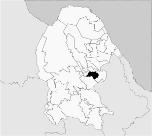
Monclova Municipality
Municipality in the Mexican state of Coahuila
Distance: Approx. 255 meters
Latitude and longitude: 26.91027778,-101.42222222
Monclova is one of the 38 municipalities of Coahuila, in north-eastern Mexico. The municipal seat lies at Monclova. The municipality covers an area of 1480 km2.
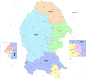
Third federal electoral district of Coahuila
Federal electoral district of Mexico
Distance: Approx. 1036 meters
Latitude and longitude: 26.9,-101.41666667
The third federal electoral district of Coahuila (Distrito electoral federal 03 de Coahuila) is one of the 300 electoral districts into which Mexico is divided for elections to the federal Chamber of Deputies and one of eight such districts in the state of Coahuila. It elects one deputy to the lower house of Congress for each three-year legislative sesssion by means of the first-past-the-post system. Votes cast in the district also count towards the calculation of proportional representation ("plurinominal") deputies elected from the second region.
Weather in this IP's area
scattered clouds
29 Celsius
34 Celsius
29 Celsius
29 Celsius
1008 hPa
74 %
1008 hPa
942 hPa
10000 meters
5.14 m/s
20 degree
40 %
06:32:44
18:46:40