Country:
 Mexico
Region:
City:
Latitude and Longitude:
Time Zone:
Postal Code:
IP information under different IP Channel
ip-api
Country
Region
City
ASN
Time Zone
ISP
Blacklist
Proxy
Latitude
Longitude
Postal
Route
IPinfo
Country
Region
City
ASN
Time Zone
ISP
Blacklist
Proxy
Latitude
Longitude
Postal
Route
MaxMind
Country
Region
City
ASN
Time Zone
ISP
Blacklist
Proxy
Latitude
Longitude
Postal
Route
Luminati
Country
MXRegion
nle
City
apodaca
ASN
Time Zone
America/Monterrey
ISP
UNINET
Latitude
Longitude
Postal
db-ip
Country
Region
City
ASN
Time Zone
ISP
Blacklist
Proxy
Latitude
Longitude
Postal
Route
ipdata
Country
Region
City
ASN
Time Zone
ISP
Blacklist
Proxy
Latitude
Longitude
Postal
Route
Popular places and events near this IP address

Tampico
City in Tamaulipas, Mexico
Distance: Approx. 4379 meters
Latitude and longitude: 22.25527778,-97.86861111
Tampico is a city and port in the southeastern part of the Mexican state of Tamaulipas. It is located on the north bank of the Pánuco River, about 10 kilometers (6 mi) inland from the Gulf of Mexico, and directly north of the state of Veracruz. Tampico is the fifth-largest city in Tamaulipas, with a population of 314,418 in the city proper and 929,174 in the metropolitan area.

Ciudad Madero
City in Tamaulipas, Mexico
Distance: Approx. 3304 meters
Latitude and longitude: 22.2475,-97.8375
Ciudad Madero is a coastal city located on the Gulf of Mexico in the southeastern part of the Mexican state of Tamaulipas. Lying within the metropolitan area of Tampico, it is the seventh most populous city in the state, with a census-estimated 2015 population of 209,175 within an area of 18.0 square miles (46.6 km2) the city is the third-largest in the Tampico metropolitan area. It is also an important center for oil refining.
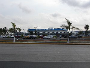
Tampico International Airport
International airport in Tampico, Tamaulipas, Mexico
Distance: Approx. 4009 meters
Latitude and longitude: 22.29638889,-97.86583333
Tampico International Airport (Spanish: Aeropuerto Internacional de Tampico); officially Aeropuerto Internacional General Francisco Javier Mina (General Francisco Javier Mina International Airport) (IATA: TAM, ICAO: MMTM) is an international airport situated in Tampico, Tamaulipas, Mexico. It manages air traffic for the metropolitan area of Tampico, including Ciudad Madero and Altamira, handling both national and international flights. The airport also accommodates military facilities and supports logistics, cargo, flight training, and general aviation activities.
Instituto Tecnológico de Ciudad Madero
Technological institute in Ciduad Madero, Tamaulipas, Mexico
Distance: Approx. 2933 meters
Latitude and longitude: 22.25333333,-97.84583333
Instituto Tecnológico de Ciudad Madero is a technological institute in Ciudad Madero, Tamaulipas, Mexico. Commonly abbreviated as ITCM. ITCM is part of the Mexican public education system (SEP) and offers several careers mainly related to the industrial needs of the region.

Pánuco River
River in Mexico
Distance: Approx. 5252 meters
Latitude and longitude: 22.26666667,-97.78333333
The Pánuco River (Spanish: Río Pánuco, Spanish pronunciation: [ˈpanuko] ), also known as the Río de Canoas, is a river in Mexico fed by several tributaries including the Moctezuma River and emptying into the Gulf of Mexico. The river is approximately 510 kilometres (320 mi) long and passes through or borders the states of Mexico, Hidalgo, Querétaro, San Luis Potosí, Tamaulipas, and Veracruz. According to the Atlas of Mexico, it is the fourth-largest river in Mexico by volume of runoff, and forms the sixth-largest river basin in Mexico by area.

Estadio Tamaulipas
Distance: Approx. 1843 meters
Latitude and longitude: 22.27997778,-97.85067778
The Estadio Tamaulipas is a football stadium in the southern portion of the Mexican state of Tamaulipas, serving as the home of C.D.S. Tampico Madero It sits across two municipalities, Tampico and Ciudad Madero, and has a capacity of 19,667. The center line of the stadium sits on the municipal boundary.

Tampico Bridge
Bridge in Veracruz, Mexico
Distance: Approx. 5421 meters
Latitude and longitude: 22.22833333,-97.83694444
The Tampico Bridge (Spanish: Puente Tampico) is a vehicular cable-stayed bridge connecting the Mexican states of Tamaulipas and Veracruz in eastern Mexico.

Tampico Mexico Temple
Distance: Approx. 3443 meters
Latitude and longitude: 22.254262,-97.855869
The Tampico Mexico Temple is the 83rd operating temple of the Church of Jesus Christ of Latter-day Saints (LDS Church).

Las Flores (archaeological site)
Distance: Approx. 5454 meters
Latitude and longitude: 22.24944444,-97.87694444
Las Flores is an archaeological site pertaining to the Huastec civilization in the city of Tampico, Tamaulipas, in Mexico.
Universidad del Noreste
Distance: Approx. 4092 meters
Latitude and longitude: 22.2834,-97.8722
The Universidad del Noreste (UNE) (Northeastern University), is a private Mexican university founded in 1970; it was the first private institution of higher education established in the state of Tamaulipas. UNE is located in Tampico. UNE enrolls students from the local area, along with students from around the world who board at the school.
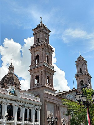
Tampico Cathedral
Church in Tampico, Mexico
Distance: Approx. 7190 meters
Latitude and longitude: 22.21638889,-97.8575
The Immaculate Conception Cathedral (also Tampico Cathedral; Spanish: Catedral de la Inmaculada Concepción) is the main Catholic church in the Diocese of Tampico in Tampico, Tamaulipas, Mexico. It is located opposite the Plaza de Armas, in the historical center of the city. The erection of the Cathedral of Tampico was not carried out until 1841; the first stone was placed on May 9.
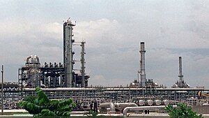
Francisco I. Madero Refinery
Distance: Approx. 2849 meters
Latitude and longitude: 22.27027778,-97.80638889
The Francisco I. Madero Refinery is an oil refinery located in Ciudad Madero, Tamaulipas, "founded in 1914 by the company El Águila", is currently owned and operated by Pemex, and is one of six refineries of Mexico.
Weather in this IP's area
haze
30 Celsius
37 Celsius
29 Celsius
30 Celsius
1009 hPa
84 %
1009 hPa
1009 hPa
8047 meters
3.6 m/s
130 degree
40 %
06:19:08
18:31:33