Country:
 Brazil
Region:
City:
Latitude and Longitude:
Time Zone:
Postal Code:
IP information under different IP Channel
ip-api
Country
Region
City
ASN
Time Zone
ISP
Blacklist
Proxy
Latitude
Longitude
Postal
Route
IPinfo
Country
Region
City
ASN
Time Zone
ISP
Blacklist
Proxy
Latitude
Longitude
Postal
Route
MaxMind
Country
Region
City
ASN
Time Zone
ISP
Blacklist
Proxy
Latitude
Longitude
Postal
Route
Luminati
Country
BRRegion
sp
City
ferrazdevasconcelos
ASN
Time Zone
America/Sao_Paulo
ISP
Uniao Networks Telecom Ltda Me
Latitude
Longitude
Postal
db-ip
Country
Region
City
ASN
Time Zone
ISP
Blacklist
Proxy
Latitude
Longitude
Postal
Route
ipdata
Country
Region
City
ASN
Time Zone
ISP
Blacklist
Proxy
Latitude
Longitude
Postal
Route
Popular places and events near this IP address

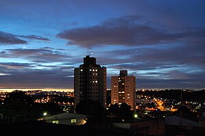
Ferraz de Vasconcelos
Place in Southeast, Brazil
Distance: Approx. 545 meters
Latitude and longitude: -23.54111111,-46.36888889
Ferraz de Vasconcelos is a municipality in the state of São Paulo in Brazil. It is part of the Metropolitan Region of São Paulo. The population is 196,500 (2020 est.) in an area of 29.56 km2.
Poá
Municipality in Southeast, Brazil
Distance: Approx. 3138 meters
Latitude and longitude: -23.52861111,-46.345
Poá is a municipality in the state of São Paulo in Brazil. The water extracted from Fonte Áurea, or the Golden Fountain, is sold throughout Brazil. The population is 103,765 (2022 est.) in an area of 17.26 km2.
Guaio River
River in Brazil
Distance: Approx. 4905 meters
Latitude and longitude: -23.51666667,-46.33333333
The Guaio River is a river of São Paulo state in southeastern Brazil.
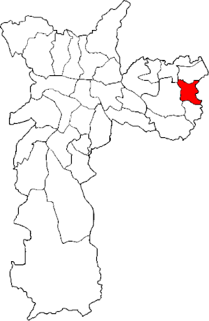
Subprefecture of Guaianases
Subprefecture in Southeast, Brazil
Distance: Approx. 4864 meters
Latitude and longitude: -23.55,-46.41666667
The Subprefecture of Guaianases is one of 32 subprefectures of the city of São Paulo, Brazil. It comprises two districts: Guaianases and Lajeado.

Subprefecture of Itaim Paulista
Subprefecture in Southeast, Brazil
Distance: Approx. 4919 meters
Latitude and longitude: -23.50472222,-46.38638889
The Subprefecture of Itaim Paulista is one of 32 subprefectures of the city of São Paulo, Brazil. It comprises two districts: Itaim Paulista and Vila Curuçá. Itaim Paulista is the easternmost subprefecture in São Paulo.
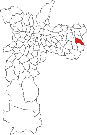
Guaianases (district of São Paulo)
District of São Paulo, Brazil
Distance: Approx. 5017 meters
Latitude and longitude: -23.5732,-46.4084
Guaianases is one of 96 districts in the city of São Paulo, Brazil. The Guaianases district was formed in the same way as Itaquera: both were born from indigenous settlements and from the efforts of the Jesuits, especially Father Manuel da Nóbrega and José de Anchieta, who founded the Jesuit school for the catechism of the Guaianás. The settlement continued, but "by around 1820 the Indians were already extinct and the land was in private hands".

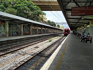
Poá (CPTM)
Railway station in São Paulo, Brazil
Distance: Approx. 3482 meters
Latitude and longitude: -23.525363,-46.343556
Poá is a train station on CPTM Line 11-Coral, located in the city of Poá.

Calmon Viana (CPTM)
Railway station in São Paulo, Brazil
Distance: Approx. 4379 meters
Latitude and longitude: -23.525436,-46.332623
Calmon Viana is a train station on CPTM Lines Line 11-Coral and 12-Sapphire, located in Calmon Viana, district of Poá.

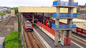
Ferraz de Vasconcelos (CPTM)
Railway station in São Paulo, Brazil
Distance: Approx. 559 meters
Latitude and longitude: -23.540998,-46.368731
Ferraz de Vasconcelos is a train station on CPTM Line 11-Coral, located in the city of Ferraz de Vasconcelos.
Antonio Gianetti Neto (CPTM)
Railway station in São Paulo, Brazil
Distance: Approx. 1747 meters
Latitude and longitude: -23.554359,-46.383687
Antonio Gianetti Neto is a train station on CPTM Line 11-Coral, located in the city of Ferraz de Vasconcelos.

José Bonifácio (CPTM)
Railway station in São Paulo, Brazil
Distance: Approx. 4751 meters
Latitude and longitude: -23.542316,-46.415584
José Bonifácio is a train station on CPTM Line 11-Coral, located in the district of José Bonifácio, East Side of São Paulo. The station also has an integrated urban bus terminal with lines that attend Areas 3 (yellow) and 4 (red).
Guaianases (CPTM)
Railway station in São Paulo, Brazil
Distance: Approx. 4751 meters
Latitude and longitude: -23.542316,-46.415584
Guaianases is a train station on CPTM Line 11-Coral, located in the limits between Lajeado and Guaianases districts, both in the East Side São Paulo.
Weather in this IP's area
clear sky
19 Celsius
19 Celsius
19 Celsius
23 Celsius
1015 hPa
82 %
1015 hPa
928 hPa
10000 meters
4.12 m/s
80 degree
05:45:21
18:04:29