Country:
 Brazil
Region:
City:
Latitude and Longitude:
Time Zone:
Postal Code:
IP information under different IP Channel
ip-api
Country
Region
City
ASN
Time Zone
ISP
Blacklist
Proxy
Latitude
Longitude
Postal
Route
IPinfo
Country
Region
City
ASN
Time Zone
ISP
Blacklist
Proxy
Latitude
Longitude
Postal
Route
MaxMind
Country
Region
City
ASN
Time Zone
ISP
Blacklist
Proxy
Latitude
Longitude
Postal
Route
Luminati
Country
BRRegion
sc
City
blumenau
ASN
Time Zone
America/Sao_Paulo
ISP
BR.Digital Provider
Latitude
Longitude
Postal
db-ip
Country
Region
City
ASN
Time Zone
ISP
Blacklist
Proxy
Latitude
Longitude
Postal
Route
ipdata
Country
Region
City
ASN
Time Zone
ISP
Blacklist
Proxy
Latitude
Longitude
Postal
Route
Popular places and events near this IP address
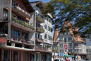
Blumenau
Municipality in South, Brazil
Distance: Approx. 7846 meters
Latitude and longitude: -26.93333333,-49.05
Blumenau (Brazilian Portuguese: [blumeˈnaw]) is a city in Vale do Itajaí, Santa Catarina state, in the South Region of Brazil, 130 km (81 mi) from the state capital Florianópolis. The city was founded by the German chemist and pharmacist Hermann Blumenau (1819–1899), who arrived on a boat via the Itajaí-Açu River accompanied by seventeen other Germans, and still celebrates its German heritage, including the second largest Oktoberfest in the world.

Vale do Itajaí
Mesoregion in Santa Catarina, Brazil
Distance: Approx. 5628 meters
Latitude and longitude: -26.91888889,-49.06583333
Vale do Itajaí also known as Vale Europeu (or "European Valley") is a mesoregion located in the Northeastern part of the Brazilian state of Santa Catarina. It has about 1.3 million inhabitants and comprises four smaller regions: Blumenau, Itajaí, Ituporanga and Rio do Sul. Most of the population is of German and Italian ancestry.

Roman Catholic Diocese of Blumenau
Catholic ecclesiastical territory
Distance: Approx. 5633 meters
Latitude and longitude: -26.9195,-49.0668
The Roman Catholic Diocese of Blumenau (Latin: Dioecesis Florumpratensis) is a diocese located in the city of Blumenau in the ecclesiastical province of Florianópolis in Brazil.
Garcia River (Brazil)
River in Brazil
Distance: Approx. 5376 meters
Latitude and longitude: -26.91666667,-49.06666667
The Garcia River is a river of Santa Catarina state in southeastern Brazil.
Engano River (Itajaí River tributary)
River in Brazil
Distance: Approx. 8615 meters
Latitude and longitude: -26.88333333,-49.18333333
The Engano River is a river of Santa Catarina state in southeastern Brazil. It is a tributary of the Itajaí-Açu River.
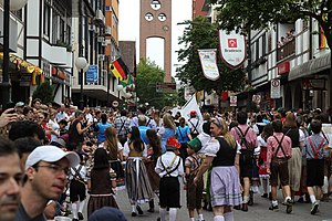
Oktoberfest of Blumenau
Distance: Approx. 4511 meters
Latitude and longitude: -26.91546667,-49.08403889
The Oktoberfest of Blumenau is a festival of German traditions that happens in middle October in the city of Blumenau, Santa Catarina, Brazil. It is considered the 2nd biggest German festival in the Americas, and the third biggest Oktoberfest celebration in the world after the original Oktoberfest from Munich. It takes place at Parque Vila Germânica (Germanic Village Park), located in the Bairro da Velha (District of the Old Woman), and lasts for 18 days.
Itoupava Central
Distance: Approx. 6806 meters
Latitude and longitude: -26.81666667,-49.08333333
Itoupava Central is a neighborhood of Blumenau, Santa Catarina, Brazil located on north zone of the River Itajai-Açu. The principal streets are Alex Borchardt, better known as Sunset (in Portuguese: Pôr do sol), Pedro Zimmermann and Gustavo Zimmermann. A small part of this neighborhood is subject to flooding.

Blumenau Airport
Airport
Distance: Approx. 5013 meters
Latitude and longitude: -26.83166667,-49.09361111
Quero-quero Airport (IATA: BNU, ICAO: SSBL), is the airport serving Blumenau, Brazil. It is named after a bird found in the area: Vanellus chilensis (Southern lapwing).
Weather in this IP's area
clear sky
17 Celsius
16 Celsius
17 Celsius
18 Celsius
1020 hPa
56 %
1020 hPa
1018 hPa
10000 meters
0.67 m/s
1.6 m/s
270 degree
3 %
06:21:30
18:06:42