Country:
 Panama
Region:
City:
Latitude and Longitude:
Time Zone:
Postal Code:
IP information under different IP Channel
ip-api
Country
Region
City
ASN
Time Zone
ISP
Blacklist
Proxy
Latitude
Longitude
Postal
Route
IPinfo
Country
Region
City
ASN
Time Zone
ISP
Blacklist
Proxy
Latitude
Longitude
Postal
Route
MaxMind
Country
Region
City
ASN
Time Zone
ISP
Blacklist
Proxy
Latitude
Longitude
Postal
Route
Luminati
Country
PARegion
8
City
panamacity
ASN
Time Zone
America/Panama
ISP
Cable & Wireless Panama
Latitude
Longitude
Postal
db-ip
Country
Region
City
ASN
Time Zone
ISP
Blacklist
Proxy
Latitude
Longitude
Postal
Route
ipdata
Country
Region
City
ASN
Time Zone
ISP
Blacklist
Proxy
Latitude
Longitude
Postal
Route
Popular places and events near this IP address
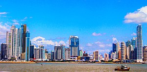
Panama City
Capital and the largest city of Panama
Distance: Approx. 1454 meters
Latitude and longitude: 8.98333333,-79.51666667
Panama City, also known as Panama (or Panamá in Spanish), is the capital and largest city of Panama. It has a total population of 1,086,990, with over 2,100,000 in its urban area. The city is located at the Pacific entrance of the Panama Canal, in the province of Panama.
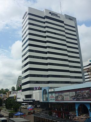
National Bank of Panama
Distance: Approx. 889 meters
Latitude and longitude: 8.9878,-79.5269
The National Bank of Panama (Spanish: Banco Nacional de Panamá) (BNP) is one of two Panamanian government-owned banks. As of January 2009, it held deposits of about US$5 billion. The other government-owned bank is Caja de Ahorros de Panamá (Savings Bank of Panama), with about US$1 billion in total deposits.
Estadio Javier Cruz
Distance: Approx. 1456 meters
Latitude and longitude: 8.98777778,-79.53416667
Estadio Javier Cruz 'Artes y Oficios' is a multi-purpose stadium. It located at the corner of Ricardo J. Alfaro Avenue and Vía Simón Bolivar in Panama City, Republic of Panama; close to Colegio de Artes Y Oficios Melchor Lasso de La Vega, from which it has received part of his name. It is currently used mostly for football matches and is the home stadium of Tierra Firme F.C. from the Liga Nacional de Ascenso.

Panamá District
District in Panamá, Panama
Distance: Approx. 1454 meters
Latitude and longitude: 8.98333333,-79.51666667
Panamá is a district (distrito) of Panamá Province in Panama. The population according to the 2010 census was 880,691; the latest official estimate (for 2019) is 1,183,333. The district covers a total area of 2,031 km2.

F&F Tower
Office tower in Panama City, Panama
Distance: Approx. 1404 meters
Latitude and longitude: 8.983,-79.5185
The F&F Tower (previously known as the Revolution Tower and locally nicknamed the Corkscrew or the Screw) is a 242.9 meter (796 foot) 52 story skyscraper completed in 2011 in Panama City, Panama designed by Pinzon Lozano & Asociados Arquitectos.
Timeline of Panama City
Distance: Approx. 1454 meters
Latitude and longitude: 8.98333333,-79.51666667
The following is a timeline of the history of Panama City, Republic of Panama.
Bella Vista, Panama City
Corregimiento in Panamá, Panama
Distance: Approx. 819 meters
Latitude and longitude: 8.9875,-79.5239
Bella Vista is a corregimiento within Panama City, in Panama District, Panama Province, Panama with a population of 30,136 as of 2010. Its population as of 1990 was 24,986; its population as of 2000 was 28,421.
The Oxford School (Panama)
Distance: Approx. 1035 meters
Latitude and longitude: 8.9915,-79.5318
The Oxford School is a British international school in Panama City, Panama. The school, located in Edison Park on Via Transistmica, has over 900 students as of 2015. It serves levels preschool through secondary school.

Iglesia del Carmen metro station
Panama metro station
Distance: Approx. 1475 meters
Latitude and longitude: 8.98222222,-79.52722222
Iglesia del Carmen is a Panama Metro station on Line 1. It was one of the metro network's first 11 stations, opened on 5 April 2014 and commencing operations the following day. The station is named after the nearby neo-gothic church.

Vía Argentina metro station
Panama metro station
Distance: Approx. 547 meters
Latitude and longitude: 8.99,-79.52194444
Vía Argentina is a Panama Metro station on Line 1. It was one of the metro network's first 11 stations, opened on 5 April 2014 and commencing operations the following day. The station serves the neighbourhoods of Obarrio and El Cangrejo, providing access to the city's financial and banking district.

Fernández de Córdoba metro station
Panama metro station
Distance: Approx. 401 meters
Latitude and longitude: 8.99638889,-79.51972222
Fernández de Córdoba is a Panama Metro station on Line 1. The tunnels to the station were completed in August 2012 and it was one of the first 11 stations when the metro began operations on 6 April 2014. The station serves the Vista Hermosa neighbourhood.

El Ingenio metro station
Panama metro station
Distance: Approx. 1514 meters
Latitude and longitude: 9.00777778,-79.51888889
El Ingenio is a Panama Metro station on Line 1. It was originally scheduled to open in August 2014, but opened on 8 May 2015. The station cost US$30 million and was officially opened by ministers Roberto Roy and Álvaro Alemán.
Weather in this IP's area
light rain
27 Celsius
30 Celsius
26 Celsius
28 Celsius
1005 hPa
85 %
1005 hPa
1003 hPa
10000 meters
2.06 m/s
340 degree
75 %
06:07:37
18:15:54