Country:
 Belize
Region:
City:
Latitude and Longitude:
Time Zone:
Postal Code:
IP information under different IP Channel
ip-api
Country
Region
City
ASN
Time Zone
ISP
Blacklist
Proxy
Latitude
Longitude
Postal
Route
IPinfo
Country
Region
City
ASN
Time Zone
ISP
Blacklist
Proxy
Latitude
Longitude
Postal
Route
MaxMind
Country
Region
City
ASN
Time Zone
ISP
Blacklist
Proxy
Latitude
Longitude
Postal
Route
Luminati
Country
BZRegion
bz
City
belizecity
ASN
Time Zone
America/Belize
ISP
Speednet Communications Limited
Latitude
Longitude
Postal
db-ip
Country
Region
City
ASN
Time Zone
ISP
Blacklist
Proxy
Latitude
Longitude
Postal
Route
ipdata
Country
Region
City
ASN
Time Zone
ISP
Blacklist
Proxy
Latitude
Longitude
Postal
Route
Popular places and events near this IP address
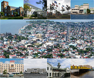
Belize City
Largest city in Belize
Distance: Approx. 823 meters
Latitude and longitude: 17.49861111,-88.18861111
Belize City is the largest city in Belize. It was once the capital of the former British Honduras. According to the 2010 census, Belize City has a population of 61,461 people.
Holy Redeemer Primary School
Distance: Approx. 1045 meters
Latitude and longitude: 17.49677222,-88.18728889
Holy Redeemer Primary School is a Catholic, parish primary school located in the heart of Belize City, Belize.

Roman Catholic Diocese of Belize City–Belmopan
Latin Catholic ecclesiastical jurisdiction in Central America
Distance: Approx. 842 meters
Latitude and longitude: 17.49769444,-88.18894444
The Roman Catholic Diocese of Belize City–Belmopan (Latin: Dioecesis Belizepolitanus-Belmopanus) is a diocese of the Latin Church of the Roman Catholic Church in continental Central America. The diocese comprises the entirety of Belize, the former British dependency British Honduras. It is a Latin suffragan of the Archdiocese of Kingston (on Jamaica) and a member of the Antilles Episcopal Conference, yet still depends on the missionary Roman Congregation for the Evangelization of Peoples.
MCC Grounds (stadium)
Stadium in Belize City, Belize
Distance: Approx. 744 meters
Latitude and longitude: 17.50444444,-88.18916667
The Marylebone Cricket Club Grounds (MCC Grounds for short) is a Belizean football stadium, located on the Northside of Belize City, Belize.
Holy Redeemer Cathedral
Church in Belize City, Belize
Distance: Approx. 1116 meters
Latitude and longitude: 17.49611111,-88.18694444
Holy Redeemer Cathedral is a Roman Catholic cathedral in the city of Belize City, Belize. It is canonically the mother church of the Roman Catholic Diocese of Belize City-Belmopan. It shares the role with Our Lady of Guadalupe Co-Cathedral in Belmopan, though the Bishop's offices remain at Holy Redeemer.
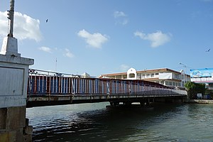
Swing Bridge (Belize)
Bridge in Belize
Distance: Approx. 1158 meters
Latitude and longitude: 17.4954,-88.187
The Belize City Swing Bridge is a swing bridge located in downtown Belize City, Belize. It connects the north side of Belize City with the south side and spans Haulover Creek, a tributary of the Belize River. A tourist destination and historical landmark of Belize, it is the oldest swing bridge in Central America and one of the few manually operated swing bridges in the world still in use.
Karl Heusner Memorial Hospital
Hospital in Belize City, Belize
Distance: Approx. 600 meters
Latitude and longitude: 17.507192,-88.195646
Karl Heusner Memorial Hospital (formerly the Old Belize City Hospital) is the main public hospital in Belize City, Belize. It functions as both the national referral hospital, and the district hospital for Belize District. It is located on Princess Margaret Drive, next to the offices of the Belize Social Security Board.
Belize Medical Associates
Hospital in Belize City, Belize
Distance: Approx. 711 meters
Latitude and longitude: 17.508,-88.194
Belize Medical Associates is a private hospital in Belize City, Belize. It was developed in 1988, as a single clinic. A decade after they opened, in 1998, they changed from a private clinic into a small hospital featuring two surgical theaters and 18 beds.
Belize High School
Private school in Belize City, Belize
Distance: Approx. 587 meters
Latitude and longitude: 17.506578,-88.197933
Belize High School is a secondary school, high school in Belize City, Belize.
Holy Redeemer Catholic Parish, Belize City
Distance: Approx. 1116 meters
Latitude and longitude: 17.49611111,-88.18694444
When the Holy Redeemer Catholic parish was founded in 1852, it was the only parish in Belize and from it missionaries covered the whole country. When other parishes were founded Holy Redeemer remained a parish with its own history but with its leadership connected to the Catholic church in all of Belize under titles of governance that evolved over the years from apostolic prefect to apostolic vicar to bishop. It has remained the hub of the diocese, the bishop's church, as well as a parish in its own right.

St. Martin de Porres Church, Belize City
Roman Catholic Parish
Distance: Approx. 641 meters
Latitude and longitude: 17.49889444,-88.20081667
St. Martin de Porres Catholic Church is a parish of the Roman Catholic Church on the southwest side of Belize City, Belize.
Port of Belize
Port in Belize
Distance: Approx. 823 meters
Latitude and longitude: 17.49861111,-88.18861111
The Port of Belize is the premier port facility in Belize. It is the port of Belize City, handling containers, breakbulk, tankers, ro-ro cargo, as well as cruise ships in the anchorage.
Weather in this IP's area
light rain
24 Celsius
24 Celsius
24 Celsius
24 Celsius
1011 hPa
41 %
1011 hPa
1011 hPa
10000 meters
6.03 m/s
8.18 m/s
103 degree
100 %
05:47:16
17:27:21