Country:
 Chile
ChileRegion:
City:
Latitude and Longitude:
Time Zone:
Postal Code:
IP information under different IP Channel
ip-api
Country
Region
City
ASN
Time Zone
ISP
Blacklist
Proxy
Latitude
Longitude
Postal
Route
IPinfo
Country
Region
City
ASN
Time Zone
ISP
Blacklist
Proxy
Latitude
Longitude
Postal
Route
MaxMind
Country
Region
City
ASN
Time Zone
ISP
Blacklist
Proxy
Latitude
Longitude
Postal
Route
Luminati
Country
CLRegion
vs
City
valparaiso
ASN
Time Zone
America/Santiago
ISP
Telmex Servicios Empresariales S.A.
Latitude
Longitude
Postal
db-ip
Country
Region
City
ASN
Time Zone
ISP
Blacklist
Proxy
Latitude
Longitude
Postal
Route
ipdata
Country
Region
City
ASN
Time Zone
ISP
Blacklist
Proxy
Latitude
Longitude
Postal
Route
Popular places and events near this IP address

Valparaíso Region
Region of Chile
Distance: Approx. 963 meters
Latitude and longitude: -33.04333333,-71.62388889
The Valparaíso Region (Spanish: Región de Valparaíso, pronounced [balpaɾaˈiso]) is one of Chile's 16 first order administrative divisions. With the country's second-highest population of 1,790,219 as of 2017, and fourth-smallest area of 16,396.1 km2 (6,331 sq mi), the region is Chile's second most densely populated after the Santiago Metropolitan Region to the southeast. The region also includes Chile's remote islands of the Pacific Ocean, including Rapa Nui and the Juan Fernandez Islands.

Iglesia de la Matriz
Distance: Approx. 638 meters
Latitude and longitude: -33.0363,-71.6322
The Iglesia de La Matriz del Salvador (The Matriz Church of the Saviour) is a church in the city of Valparaíso, Chile. Located in the heart of the port district (Barrio Puerto) of the city, surrounded by cobblestone streets and houses it has a historical importance in the city and was declared a National Monument of Chile in 1971.
Plaza Aníbal Pinto
Distance: Approx. 934 meters
Latitude and longitude: -33.04315278,-71.62463333
The Plaza Aníbal Pinto is a plaza built on reclaimed land in Valparaíso, Chile. Formerly Plaza del Orden, Plaza Aníbal Pinto is named after Aníbal Pinto. It features a fountain called "Fuente de Neptuno" (Fountain of Neptune), which was erected in 1892.

Artillería funicular railway
National monument of Chile
Distance: Approx. 466 meters
Latitude and longitude: -33.03333333,-71.63027778
The Ascensor Artillería is one of the 16 funicular railways located in the Chilean city of Valparaíso. It links the "plan" (flat area) of the city with the Artillería hill, and is privately owned. The line runs all year.

FONDART
Distance: Approx. 504 meters
Latitude and longitude: -33.03846667,-71.62876667
FONDART or “Fondo Nacional para el Desarrollo Cultural y las Artes” (English: “National Fund for the Development of Culture and the Arts”), is a Chilean public program of the governmental agency Consejo Nacional de la Cultura y las Artes (English: National Council of Culture and Arts) which provides public funding for projects dedicated to the promotion of arts, culture, and heritage. The Council headquarters are located in Plaza Sotomayor, Valparaíso.

Plan de Valparaíso
Distance: Approx. 971 meters
Latitude and longitude: -33.04321111,-71.62284722
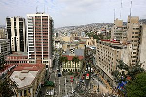
The Plan de Valparaíso is the name given to the flat part of Valparaíso, Chile, where public and commercial buildings are found, distinguishing it from the hills (cerros) where the majority of the population live. Traditionally, the plan is divided into sectors Barrio Puerto, originally the nucleus of the city, and El Almendral, a preferentially dedicated trade zone.

Barrio Puerto
Distance: Approx. 453 meters
Latitude and longitude: -33.03685,-71.62978889
Barrio Puerto (English: the port neighborhood) is the area located between the Plaza Wheelwright and Plaza Sotomayor in the downtown area of Valparaíso, Chile.
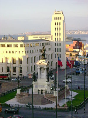
Plaza Sotomayor
Distance: Approx. 504 meters
Latitude and longitude: -33.03846667,-71.62876667
The Plaza Sotomayor is a plaza in Valparaíso, Chile. It is named after Rafael Sotomayor. The square is lined by buildings occupying full block-fronts of the streets that flank it.

Palacio Baburizza
Distance: Approx. 695 meters
Latitude and longitude: -33.0404,-71.6289
Palacio Baburizza is the former residence of Croatian businessman Pascual Baburizza located in Valparaíso, Chile. It was built in 1916 by Italian architects, and eventually turned into a museum in 1971, and declared a historic monument in 1976.

Cementerio N° 1 de Valparaíso
Cemetery in Valparaíso, Chile
Distance: Approx. 1091 meters
Latitude and longitude: -33.0446,-71.6253
The Cementerio N° 1 de Valparaíso is a cemetery located in the Panteón Hill, immediately north of the Cementerio de Disidentes, in Valparaíso, Chile. Created in 1825, it was declared as a National Monument of Chile in 2005, within the category of Historic Monuments.

Edificio Armada de Chile
National monument of Chile
Distance: Approx. 584 meters
Latitude and longitude: -33.0389,-71.6295
The Edificio de la Comandancia en Jefe de la Armada de Chile, also known as Edificio de la Intendencia de Valparaíso, because it was a purpose-built Intendencia, is a building designed in an eclectic style with Renaissance Revival architecture elements, which rises 5 floors in height and covers 8,000 square metres (86,000 sq ft). The main facade of the building faces the Plaza Sotomayor of Valparaíso and the Monument to the Heroes of Iquique. The building has been the site of historical and social events, which were numerous and important.

St. Paul's Cathedral, Valparaíso
National monument and Anglican church in Valparaíso, Chile
Distance: Approx. 853 meters
Latitude and longitude: -33.04234,-71.62723
St. Paul's Cathedral (Spanish: Catedral de San Pablo) is a historic Anglican church in Valparaíso, Chile. Located in Cerro Concepción in the historic British section of Valparaíso, St.
Weather in this IP's area
clear sky
19 Celsius
18 Celsius
17 Celsius
19 Celsius
1016 hPa
62 %
1016 hPa
1016 hPa
10000 meters
3.09 m/s
300 degree
07:38:03
19:41:34