Country:
 Bolivia
Region:
City:
Latitude and Longitude:
Time Zone:
Postal Code:
IP information under different IP Channel
ip-api
Country
Region
City
ASN
Time Zone
ISP
Blacklist
Proxy
Latitude
Longitude
Postal
Route
IPinfo
Country
Region
City
ASN
Time Zone
ISP
Blacklist
Proxy
Latitude
Longitude
Postal
Route
MaxMind
Country
Region
City
ASN
Time Zone
ISP
Blacklist
Proxy
Latitude
Longitude
Postal
Route
Luminati
Country
BOASN
Time Zone
America/La_Paz
ISP
Nuevatel PCS de Bolivia S.A.
Latitude
Longitude
Postal
db-ip
Country
Region
City
ASN
Time Zone
ISP
Blacklist
Proxy
Latitude
Longitude
Postal
Route
ipdata
Country
Region
City
ASN
Time Zone
ISP
Blacklist
Proxy
Latitude
Longitude
Postal
Route
Popular places and events near this IP address

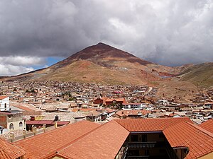
Potosí
City in Bolivia
Distance: Approx. 255 meters
Latitude and longitude: -19.58916667,-65.75333333
Potosí, known as Villa Imperial de Potosí in the colonial period, is the capital city and a municipality of the Department of Potosí in Bolivia. It is one of the highest cities in the world at a nominal 4,090 m (13,420 ft). For centuries, it was the location of the Spanish colonial silver mint.

Cerro Rico
Mountain near Potosí, Bolivia
Distance: Approx. 3307 meters
Latitude and longitude: -19.61888889,-65.74972222
Cerro Rico (Spanish for "Rich Mountain"), Cerro Potosí ("Potosí Mountain") or Sumaq Urqu (Quechua sumaq "beautiful, good, pleasant", urqu "mountain", "beautiful (good or pleasant) mountain"), is a mountain in the Andes near the Bolivian city of Potosí. Cerro Rico, which is popularly conceived of as being "made of" silver ore, is famous for providing vast quantities of silver for the Spanish Empire, most of which was shipped to metropolitan Spain. It is estimated that eighty-five percent of the silver produced in the central Andes during this time came from Cerro Rico.
Estadio Víctor Agustín Ugarte
Stadium in Bolivia
Distance: Approx. 1593 meters
Latitude and longitude: -19.57861111,-65.76111111
Estadio Víctor Agustín Ugarte, also known by its old name Estadio Mario Mercado Vaca Guzmán, is a multi-purpose stadium in Potosí, Bolivia. It is currently used mostly for football matches, on club level by Real Potosí and Nacional Potosí. The stadium has a capacity of 32,000 people.

National Mint of Bolivia
Building in Potosí, Bolivia
Distance: Approx. 349 meters
Latitude and longitude: -19.58861111,-65.75416667
The National Mint of Bolivia (Spanish: Casa de la Moneda de Bolivia) or the Mint of Potosí (in colonial era) is a mint located in the city of Potosí in Bolivia. It is from this mint that most of the silver shipped through the Spanish Main came. The coinage minted during its period became so well known in the world that a saying, memorialized by Miguel de Cervantes, came into use: valer un potosí, "to be worth a potosí" (that is, "a fortune").
Captain Nicolas Rojas Airport
Airport in Bolivia
Distance: Approx. 5880 meters
Latitude and longitude: -19.54305556,-65.72361111
Capitán Nicolas Rojas Airport (Spanish: Aeropuerto Capitán Nicolas Rojas, IATA: POI, ICAO: SLPO) is an extremely high elevation airport serving the city of Potosí, the capital of the Potosí Department in Bolivia. The runway is in a shallow valley 4 kilometres (2.5 mi) northeast of the city, with mountainous terrain in a quadrants. The Potosi VOR-DME (Ident: PTS) is located 1.4 nautical miles (2.6 km) off the approach threshold of Runway 24.

Potosí Municipality
Municipality in Potosí Department, Bolivia
Distance: Approx. 3649 meters
Latitude and longitude: -19.58333333,-65.71666667
Potosí Municipality is the capital municipality of the Tomás Frías Province in the Potosí Department in Bolivia. Its seat is Potosí which is the capital of the department as well.
Tomás Frías Autonomous University
Distance: Approx. 888 meters
Latitude and longitude: -19.58388889,-65.75722222
The Tomás Frías Autonomous University (Universidad Autónoma Tomás Frías or UATF) is a public university located in Potosí, Bolivia. It was established in 1892.
Pari Urqu
Mountain in Bolivia
Distance: Approx. 660 meters
Latitude and longitude: -19.58333333,-65.75
Pari Urqu (Aymara pari red hot, Quechua pari warm, to get very hot, overheated, urqu mountain, "hot mountain", hispanicized spellings Pari Orcko, Pary Orcko, Pari Orco) is a mountain in the Andes in Bolivia, about 3,950 m (12,959 ft) high. It is located in the Potosí Department, Tomás Frías Province, Potosí Municipality. Pari Urqu lies in the west of Potosí, north west of the higher Cerro Rico (Spanish name), P'utuqsi Urqu or Sumaq Urqu (Quechua names) which lies in the south of Potosí.
Khari Khari
Mountain in Bolivia
Distance: Approx. 6865 meters
Latitude and longitude: -19.58555556,-65.68555556
Khari Khari (Quechua, a thorny medical plant, a species of rubus, hispanicized spellings Cari Cari, Kari Kari, Kari-Kari) is a mountain in the Andes in the Potosí Department of Bolivia. It is the second highest elevation in the Potosí mountain range rising up to (5,040 m (16,535 ft). It is also the highest mountain in the Khari Khari mountain range, the northern part of the Potosí mountain range.
Khari Khari Lakes
Two connected artificial lakes in Bolivia
Distance: Approx. 2929 meters
Latitude and longitude: -19.60722222,-65.73055556
The Khari Khari Lakes (Quechua khari khari a thorny medical plant, a species of rubus, hispanicized spellings Cari Cari, Kari Kari, Kari-Kari) are two closely connected artificial lakes, San Ildefonso and San Pablo (now integrated into San Ildefonso) situated in the Khari Khari mountain range of Bolivia. The lakes lie about 8 km east of Potosí in the Potosí Department, Tomás Frías Province, Potosí Municipality, northeast of the lakes named San Sebastián and Planilla which are also artificial lakes.
Yana Qaqa (Potosí)
Mountain in Bolivia
Distance: Approx. 8149 meters
Latitude and longitude: -19.51666667,-65.76138889
Yana Qaqa (Quechua yana black, qaqa rock, "black rock", also spelled Yana Khakha) is a mountain in the Bolivian Andes which reaches a height of approximately 4,180 m (13,710 ft). It is located in the Potosí Department, Tomás Frías Province, Potosí Municipality, north of the city of Potosí.

Cathedral Basilica of Potosí
Church in Potosí, Bolivia
Distance: Approx. 204 meters
Latitude and longitude: -19.5885,-65.7527
The Cathedral of Villa Imperial de Potosí or Cathedral of Potosí, the official name is Cathedral Basilica of Nuestra Señora de La Paz is a minor basilica and cathedral with baroque and neoclassical colonial influence. It has a stone facade and is located in Plaza 10 de Noviembre in the center of this Bolivian city of Potosí. It was built between 1809 and 1836 on the site where the old church collapsed in 1807.
Weather in this IP's area
broken clouds
15 Celsius
13 Celsius
15 Celsius
15 Celsius
1016 hPa
17 %
1016 hPa
642 hPa
10000 meters
5.67 m/s
6.75 m/s
11 degree
84 %
05:59:39
18:22:02