Country:
Region:
City:
Latitude and Longitude:
Time Zone:
Postal Code:
IP information under different IP Channel
ip-api
Country
Region
City
ASN
Time Zone
ISP
Blacklist
Proxy
Latitude
Longitude
Postal
Route
Luminati
Country
Region
mg
City
belohorizonte
ASN
Time Zone
America/Sao_Paulo
ISP
Vogel Solucoes em Telecom e Informatica SA
Latitude
Longitude
Postal
IPinfo
Country
Region
City
ASN
Time Zone
ISP
Blacklist
Proxy
Latitude
Longitude
Postal
Route
db-ip
Country
Region
City
ASN
Time Zone
ISP
Blacklist
Proxy
Latitude
Longitude
Postal
Route
ipdata
Country
Region
City
ASN
Time Zone
ISP
Blacklist
Proxy
Latitude
Longitude
Postal
Route
Popular places and events near this IP address

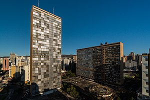
Conjunto Governador Kubitschek
Building in Belo Horizonte, Brazil
Distance: Approx. 1408 meters
Latitude and longitude: -19.92388889,-43.94583333
The JK Building is the tallest building in downtown Belo Horizonte, Brazil, named for Juscelino Kubitschek, who was the mayor of Belo Horizonte and later president of Brazil. Standing at 40 stories tall, the JK Building is the third tallest building in Brazil after the Itália Building (45 stories) and Mirante do Vale (51 stories), both in São Paulo. It was designed by Oscar Niemeyer in 1951, to work like a complete town.
Praça Raul Soares
Distance: Approx. 1462 meters
Latitude and longitude: -19.92274167,-43.94511389
The Praça Raul Soares (English: Raul Soares Square) is a major square of Belo Horizonte, Brazil. The square is named in honor of Raul Soares de Moura, former governor of Minas Gerais. It is situated at the confluence of four major avenues: Amazonas, Augusto de Lima, Bias Fortes and Olegário Maciel.

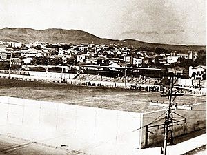
Estádio Juscelino Kubitschek de Oliveira
Distance: Approx. 962 meters
Latitude and longitude: -19.92233977,-43.94987405
Estádio Juscelino Kubitschek de Oliveira was a multi-use stadium in Belo Horizonte, Brazil. It was initially used as the stadium of Cruzeiro Esporte Clube matches. It was replaced by Estádio Independência in 1950.

Legislative Assembly of Minas Gerais
Legislative assembly of Minas Gerais, Brazil
Distance: Approx. 1423 meters
Latitude and longitude: -19.93111111,-43.95027778
The Legislative Assembly of Minas Gerais (Portuguese: Assembleia Legislativa de Minas Gerais) is the state legislature of Brazil's Minas Gerais state. It consists of 77 state deputies elected by proportional representation and is based in Belo Horizonte, the state capital. The Assembly has been based at the Palácio da Inconfidência since the building's 1972 opening; it was made a national heritage site in 2009.
Loyola College, Belo Horizonte
Jesuit, catholic school in Contorno Ave., Belo Horizonte, Minas Gerais, Brazil
Distance: Approx. 1817 meters
Latitude and longitude: -19.93541667,-43.95027778
Loyola College, Belo Horizonte is a kindergarten through secondary school in Minas Gerais state, Brazil, opened by the Society of Jesus in 1943. It is maintained by the Nobrega Association for Education and Social Assistance.

Calafate station
Belo Horizonte metro station
Distance: Approx. 1169 meters
Latitude and longitude: -19.92236111,-43.97011111
Calafate is a Belo Horizonte Metro station on Line 1. It was opened on 1 August 1986 as part of the inaugural section of the line, from Eldorado to Lagoinha. The station is located between Gameleira and Carlos Prates.
Carlos Prates station
Belo Horizonte metro station
Distance: Approx. 394 meters
Latitude and longitude: -19.91813889,-43.95730556
Carlos Prates is a Belo Horizonte Metro station on Line 1. It was opened on 1 August 1986 as part of the inaugural section of the line, from Eldorado to Lagoinha. The station is located between Calafate and Lagoinha.

Lagoinha station
Belo Horizonte metro station
Distance: Approx. 1955 meters
Latitude and longitude: -19.91297222,-43.94255556
Lagoinha is a Belo Horizonte Metro station on Line 1. It was opened on 1 August 1986 as the eastern terminus of the inaugural section of the line, from Eldorado to Lagoinha. In April 1987, the line was extended to Central.

São José Church
Catholic church in Belo Horizonte, Brazil
Distance: Approx. 2134 meters
Latitude and longitude: -19.92111111,-43.93861111
The São José church is an eclectic-style church with Neo-Gothic influence located in downtown Belo Horizonte, Minas Gerais, Brazil. It was built by the Redemptorist congregation.

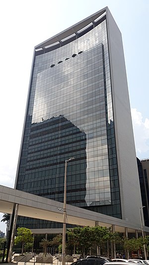
Aureliano Chaves building
Distance: Approx. 1240 meters
Latitude and longitude: -19.92842,-43.94989
The Aureliano Chaves Building is a commercial building inaugurated in 2014 in Belo Horizonte, Minas Gerais, Brazil, designed by Gustavo Penna Arquiteto & Associados and Trínia Arquitetura. The building is owned by Forluz (Fundação Forluminas de Seguridade Social), a pension fund for CEMIG employees, and is currently the tallest in the city of Belo Horizonte. The building is named after Aureliano Chaves, former governor of the state of Minas Gerais and former vice-president of Brazil.

Centro de Cultura Presidente Itamar Franco
Cultural complex in Belo Horizonte, Brazil
Distance: Approx. 683 meters
Latitude and longitude: -19.92703472,-43.95668136
The President Itamar Franco Culture Center (Portuguese: Centro de Cultura Presidente Itamar Franco) is a cultural and institutional complex located in the Barro Preto neighborhood, in Belo Horizonte, Minas Gerais, Brazil. The Center houses the Sala Minas Gerais and the headquarters of the Minas Gerais Philharmonic Orchestra, as well as the gastronomic space Mineiraria, and the headquarters of Rede Minas and Rádio Inconfidência. The complex was designed by local architects Jô Vasconcellos and Rafael Yanni, with acoustic consultancy by José Augusto Nepomuceno for the concert hall.

Sala Minas Gerais
Distance: Approx. 720 meters
Latitude and longitude: -19.92739,-43.95669
Sala Minas Gerais is a concert hall in Belo Horizonte, Minas Gerais, Brazil. Inaugurated in 2015, it was designed and built especially to serve as the headquarters of the Minas Gerais Philharmonic Orchestra. It has an area of 32,464m² and a capacity of 1,477 spectators, with areas for orchestra and choir.
Weather in this IP's area
broken clouds
28 Celsius
29 Celsius
28 Celsius
28 Celsius
1012 hPa
62 %
1012 hPa
918 hPa
10000 meters
3.02 m/s
4.02 m/s
40 degree
82 %
05:11:18
18:07:49