Country:
Region:
City:
Latitude and Longitude:
Time Zone:
Postal Code:
IP information under different IP Channel
ip-api
Country
Region
City
ASN
Time Zone
ISP
Blacklist
Proxy
Latitude
Longitude
Postal
Route
Luminati
Country
Region
mg
City
belohorizonte
ASN
Time Zone
America/Sao_Paulo
ISP
Vogel Solucoes em Telecom e Informatica SA
Latitude
Longitude
Postal
IPinfo
Country
Region
City
ASN
Time Zone
ISP
Blacklist
Proxy
Latitude
Longitude
Postal
Route
db-ip
Country
Region
City
ASN
Time Zone
ISP
Blacklist
Proxy
Latitude
Longitude
Postal
Route
ipdata
Country
Region
City
ASN
Time Zone
ISP
Blacklist
Proxy
Latitude
Longitude
Postal
Route
Popular places and events near this IP address

Belo Horizonte
Capital city of Minas Gerais, Brazil
Distance: Approx. 3722 meters
Latitude and longitude: -19.91666667,-43.93333333
Belo Horizonte is the sixth-largest city in Brazil, with a population of around 2.3 million, and the third largest metropolitan area, containing a population of 6 million. It is the 13th-largest city in South America and the 18th-largest in the Americas. The metropolis is anchor to the Belo Horizonte metropolitan area, ranked as the third most populous metropolitan area in Brazil and the 17th most populous in the Americas.

Arena Independência
Football stadium in Belo Hornzonte, Brazil
Distance: Approx. 2743 meters
Latitude and longitude: -19.90833333,-43.91777778
Estádio Raimundo Sampaio, more commonly known as Arena Independência (Independence Arena), is an association football stadium located in the Horto neighborhood of Belo Horizonte, Minas Gerais, Brazil. It was built in 1950 for the FIFA World Cup, held in Brazil. Initially its capacity was 30,000 people, but after the reconstruction between 2010 and 2012, the capacity is approximately 23,000 people.
Roman Catholic Archdiocese of Belo Horizonte
Catholic ecclesiastical territory
Distance: Approx. 981 meters
Latitude and longitude: -19.8833,-43.9333
The Roman Catholic Archdiocese of Belo Horizonte (Latin: Archidioecesis Bellohorizontinus) is an archdiocese located in the city of Belo Horizonte in Brazil.
Ribeirão Arrudas
Distance: Approx. 3569 meters
Latitude and longitude: -19.91416667,-43.93666667
Arrudas is a stream that begins its course in Contagem and goes down through Belo Horizonte in the Brazilian state of Minas Gerais. It is one of the source of Das Velhas River Rio das Velhas in Sabará. Ribeirão Arrudas is formed by many streams: Jatobá, Barreiro, Bonsucesso, Cercadinho, Piteiras, Leitão, Acaba Mundo, Serra, Taquaril, Navio-baleia, Santa Terezinha, Ferrugem, Tijuco, Pastinho, among others, which are the tributaries of Arrudas.

Lagoinha Church
Church in Minas Gerais, Brazil
Distance: Approx. 2837 meters
Latitude and longitude: -19.9004,-43.9451
Lagoinha Baptist Church (Portuguese: Igreja Batista da Lagoinha) is a charismatic Evangelical Baptist multi-site megachurch based in Belo Horizonte, Minas Gerais in Brazil. Márcio Valadão is the current senior pastor of the church. The church became known through one of its ministries, the worship ministry Diante do Trono, which is one of the world's largest ministries of praise, worship and mission.

Greater Belo Horizonte
Place in Minas Gerais, Brazil
Distance: Approx. 3722 meters
Latitude and longitude: -19.91666667,-43.93333333
Greater Belo Horizonte, Brazil, is the name usually used to describe the Belo Horizonte metropolitan region, which is composed of 34 municipalities. As of 2013, it is the third largest metropolitan area of Brazil with more than Six million inhabitants; the largest city by population is Belo Horizonte.
Horto station
Belo Horizonte metro station
Distance: Approx. 2673 meters
Latitude and longitude: -19.90611111,-43.91308333
Horto is a Belo Horizonte Metro station on Line 1. It was opened in December 1992 as a one-station extension of the line from Santa Efigênia; later, Santa Tereza was added in the middle of this extension. In December 1994, the line was extended to Santa Inês.

Santa Inês station
Belo Horizonte metro station
Distance: Approx. 1865 meters
Latitude and longitude: -19.89533333,-43.9105
Santa Inês is a Belo Horizonte Metro station on Line 1. It was opened in December 1994 as a one-station extension of the line from Horto. In April 1997 the line was extended to Minas Shopping.
José Cândido da Silveira station
Belo Horizonte metro station
Distance: Approx. 1166 meters
Latitude and longitude: -19.88361111,-43.91288889
José Cândido da Silveira is a Belo Horizonte Metro station on Line 1. It was opened in April 1997 as part of a two-station extension of the line from Santa Inês to Minas Shopping. The station is located between Santa Inês and Minas Shopping.
Minas Shopping station
Belo Horizonte metro station
Distance: Approx. 1303 meters
Latitude and longitude: -19.87322222,-43.92769444
Minas Shopping is a Belo Horizonte Metro station on Line 1. It was opened in April 1997 as a terminus of the two-station extension of the line from Santa Inês. On 5 January 2002 the line was extended to São Gabriel.

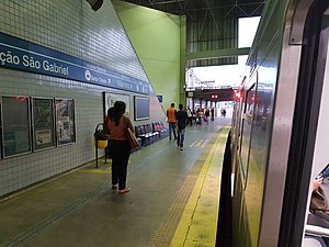
São Gabriel station
Belo Horizonte metro station
Distance: Approx. 2378 meters
Latitude and longitude: -19.86313889,-43.92625
São Gabriel is a Belo Horizonte Metro station on Line 1. It was opened on 5 January 2002 as a one-station extension of the line from Minas Shopping. In April 2002, the line was extended to Primeiro de Maio.

Primeiro de Maio station
Belo Horizonte metro station
Distance: Approx. 3119 meters
Latitude and longitude: -19.85797222,-43.93388889
Primeiro de Maio is a Belo Horizonte Metro station on Line 1. It was opened in April 2002 as a one-station extension of the line from São Gabriel. In July 2002, the line was extended to Floramar.
Weather in this IP's area
broken clouds
28 Celsius
29 Celsius
27 Celsius
28 Celsius
1012 hPa
54 %
1012 hPa
922 hPa
10000 meters
4.02 m/s
4.47 m/s
31 degree
75 %
05:11:13
18:07:38


