Country:
 Brazil
Region:
City:
Latitude and Longitude:
Time Zone:
Postal Code:
IP information under different IP Channel
ip-api
Country
Region
City
ASN
Time Zone
ISP
Blacklist
Proxy
Latitude
Longitude
Postal
Route
IPinfo
Country
Region
City
ASN
Time Zone
ISP
Blacklist
Proxy
Latitude
Longitude
Postal
Route
MaxMind
Country
Region
City
ASN
Time Zone
ISP
Blacklist
Proxy
Latitude
Longitude
Postal
Route
Luminati
Country
BRRegion
mg
City
belohorizonte
ASN
Time Zone
America/Sao_Paulo
ISP
AMERICAN TOWER DO BRASIL-COMUNICACAO MULTIMIDIA LT
Latitude
Longitude
Postal
db-ip
Country
Region
City
ASN
Time Zone
ISP
Blacklist
Proxy
Latitude
Longitude
Postal
Route
ipdata
Country
Region
City
ASN
Time Zone
ISP
Blacklist
Proxy
Latitude
Longitude
Postal
Route
Popular places and events near this IP address

Belo Horizonte
Capital city of Minas Gerais, Brazil
Distance: Approx. 783 meters
Latitude and longitude: -19.91666667,-43.93333333
Belo Horizonte is the sixth-largest city in Brazil, with a population of around 2.3 million, and the third largest metropolitan area, with a population of 6 million. It is the 13th-largest city in South America and the 18th-largest in the Americas. The metropolis is anchor to the Belo Horizonte metropolitan area, ranked as the third most populous metropolitan area in Brazil and the 17th most populous in the Americas.

Faculdade de Direito e Ciências do Estado da Universidade Federal de Minas Gerais
Distance: Approx. 532 meters
Latitude and longitude: -19.925667,-43.936686
Faculdade de Direito e Ciências do Estado da Universidade Federal de Minas Gerais (Faculty of Law and State Sciences of the Federal University of Minas Gerais) is the university's oldest unit, and even appeared before UFMG. Recognized internationally, it is considered a center of excellence in legal education, professional training with great ability and critical view. The qualification of teachers - most have the title of doctor - and the high level of students ensure the recognition of its progress.

Praça da Liberdade
Public square in Belo Horizonte
Distance: Approx. 1130 meters
Latitude and longitude: -19.93206667,-43.93806389
The Praça da Liberdade (English: Liberty Square) is a principal square in the Savassi neighborhood in the city of Belo Horizonte, Minas Gerais, Brazil.

Praça Rui Barbosa
Public square in Belo Horizonte
Distance: Approx. 783 meters
Latitude and longitude: -19.91679167,-43.93396667
The Praça Rui Barbosa (English: Rui Barbosa Square), also called Praça da Estação (Station Square), is a square in Belo Horizonte, Brazil. It has this name due to its proximity to Belo Horizonte's Central Station. The square has the first public clock in the city.

Professor Paulo Neves de Carvalho Government School
Distance: Approx. 699 meters
Latitude and longitude: -19.92638889,-43.92611111
Professor Paulo Neves de Carvalho Government School (Escola de Governo Paulo Neves de Carvalho) is a Brazilian state funded single institution of higher education, based in the city of Belo Horizonte, Minas Gerais. The school offers undergraduate, masters, specialization and extension programs in the area of Public Administration. The School of Government is part of the João Pinheiro Foundation, and is linked to the government of Minas Gerais through the Secretary of State for Planning and Management (SEPLAG).

Praça Sete de Setembro
Public square in Belo Horizonte
Distance: Approx. 849 meters
Latitude and longitude: -19.91912222,-43.93866111
The Praça Sete de Setembro (English: 7 September Square), often called Praça Sete, is a square in downtown Belo Horizonte, Minas Gerais, Brazil. It is located at the intersection of two major avenues, Afonso Pena and Amazonas, and by the streets Rio de Janeiro and Carijós. It boasts an obelisk at its center donated by the people of the neighboring Capela Nova do Betim, today the city of Betim, the inhabitants of the state capital, on the occasion of the commemoration of the centenary of the Independence of Brazil, on 7 September 1822.

Greater Belo Horizonte
Place in Minas Gerais, Brazil
Distance: Approx. 783 meters
Latitude and longitude: -19.91666667,-43.93333333
Greater Belo Horizonte, Brazil, is the name usually used to describe the Belo Horizonte metropolitan region, which is composed of 34 municipalities. As of 2013, it is the third largest metropolitan area of Brazil with more than Six million inhabitants; the largest city by population is Belo Horizonte.

Basilica of Our Lady of Lourdes, Belo Horizonte
Church in Belo Horizonte, Brazil
Distance: Approx. 903 meters
Latitude and longitude: -19.9286,-43.9389
The Basilica of Our Lady of Lourdes (Portuguese: Basílica de Nossa Senhora de Lourdes), also known as the Basilica of Belo Horizonte, is a Catholic church built in a predominantly neo-Gothic style, which is located in Belo Horizonte, Brazil. Its construction was completed around 1923. The author of the project was Manoel Tunes, and the works were made by Antonio Gonçalves Gravatá.

Central station (Belo Horizonte Metro)
Belo Horizonte metro station
Distance: Approx. 680 meters
Latitude and longitude: -19.91758333,-43.93322222
Central is a Belo Horizonte Metro station on Line 1. It was opened in April 1987 as a one-station extension of the line from Lagoinha. In April 1992 the line was extended to Santa Efigênia.
Santa Efigênia station
Belo Horizonte metro station
Distance: Approx. 1125 meters
Latitude and longitude: -19.91955556,-43.92225
Santa Efigênia is a Belo Horizonte Metro station on Line 1. It was opened in April 1992 as a one-station extension of the line from Central. In December 1992 the line was extended to Horto.

São José Church
Catholic church in Belo Horizonte, Brazil
Distance: Approx. 736 meters
Latitude and longitude: -19.92111111,-43.93861111
The São José church is an eclectic-style church with Neo-Gothic influence located in downtown Belo Horizonte, Minas Gerais, Brazil. It was built by the Redemptorist congregation.
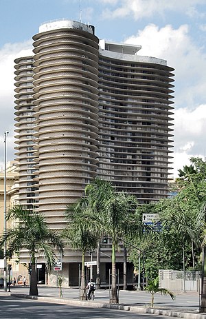
Niemeyer Building
Residential building designed by Oscar Niemeyer in Belo Horizonte, Brazil
Distance: Approx. 1151 meters
Latitude and longitude: -19.93266667,-43.93739444
The Niemeyer Building (Portuguese: Edifício Niemeyer) is a residential building located in Belo Horizonte, Brazil, designed by the architect Oscar Niemeyer and constructed between 1954 and 1960. It is an iconic piece of Brazilian modernistic architecture.
Weather in this IP's area
clear sky
26 Celsius
26 Celsius
25 Celsius
27 Celsius
1010 hPa
53 %
1010 hPa
917 hPa
10000 meters
6.69 m/s
100 degree
05:31:26
17:55:09