Country:
 Brazil
Region:
City:
Latitude and Longitude:
Time Zone:
Postal Code:
IP information under different IP Channel
ip-api
Country
Region
City
ASN
Time Zone
ISP
Blacklist
Proxy
Latitude
Longitude
Postal
Route
IPinfo
Country
Region
City
ASN
Time Zone
ISP
Blacklist
Proxy
Latitude
Longitude
Postal
Route
MaxMind
Country
Region
City
ASN
Time Zone
ISP
Blacklist
Proxy
Latitude
Longitude
Postal
Route
Luminati
Country
BRRegion
mg
City
belohorizonte
ASN
Time Zone
America/Sao_Paulo
ISP
AMERICAN TOWER DO BRASIL-COMUNICACAO MULTIMIDIA LT
Latitude
Longitude
Postal
db-ip
Country
Region
City
ASN
Time Zone
ISP
Blacklist
Proxy
Latitude
Longitude
Postal
Route
ipdata
Country
Region
City
ASN
Time Zone
ISP
Blacklist
Proxy
Latitude
Longitude
Postal
Route
Popular places and events near this IP address
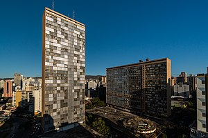
Conjunto Governador Kubitschek
Building in Belo Horizonte, Brazil
Distance: Approx. 2622 meters
Latitude and longitude: -19.92388889,-43.94583333
The JK Building is the tallest building in downtown Belo Horizonte, Brazil, named for Juscelino Kubitschek, who was the mayor of Belo Horizonte and later president of Brazil. Standing at 40 stories tall, the JK Building is the third tallest building in Brazil after the Itália Building (45 stories) and Mirante do Vale (51 stories), both in São Paulo. It was designed by Oscar Niemeyer in 1951, to work like a complete town.

Praça Raul Soares
Distance: Approx. 2545 meters
Latitude and longitude: -19.92274167,-43.94511389
The Praça Raul Soares (English: Raul Soares Square) is a major square of Belo Horizonte, Brazil. The square is named in honor of Raul Soares de Moura, former governor of Minas Gerais. It is situated at the confluence of four major avenues: Amazonas, Augusto de Lima, Bias Fortes and Olegário Maciel.

Ribeirão Arrudas
Distance: Approx. 2488 meters
Latitude and longitude: -19.91416667,-43.93666667
Arrudas is a stream that begins its course in Contagem and goes down through Belo Horizonte in the Brazilian state of Minas Gerais. It is one of the source of Das Velhas River Rio das Velhas in Sabará. Ribeirão Arrudas is formed by many streams: Jatobá, Barreiro, Bonsucesso, Cercadinho, Piteiras, Leitão, Acaba Mundo, Serra, Taquaril, Navio-baleia, Santa Terezinha, Ferrugem, Tijuco, Pastinho, among others, which are the tributaries of Arrudas.
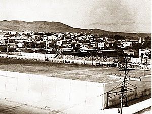
Estádio Juscelino Kubitschek de Oliveira
Distance: Approx. 2296 meters
Latitude and longitude: -19.92233977,-43.94987405
Estádio Juscelino Kubitschek de Oliveira was a multi-use stadium in Belo Horizonte, Brazil. It was initially used as the stadium of Cruzeiro Esporte Clube matches. It was replaced by Estádio Independência in 1950.

Lagoinha Church
Church in Minas Gerais, Brazil
Distance: Approx. 1297 meters
Latitude and longitude: -19.9004,-43.9451
Lagoinha Baptist Church (Portuguese: Igreja Batista da Lagoinha) is a charismatic Evangelical Baptist multi-site megachurch based in Belo Horizonte, Minas Gerais in Brazil. Márcio Valadão is the current senior pastor of the church. The church became known through one of its ministries, the worship ministry Diante do Trono, which is one of the world's largest ministries of praise, worship and mission.

Praça Sete de Setembro
Public square in Belo Horizonte
Distance: Approx. 2651 meters
Latitude and longitude: -19.91912222,-43.93866111
The Praça Sete de Setembro (English: 7 September Square), often called Praça Sete, is a square in downtown Belo Horizonte, Minas Gerais, Brazil. It is located at the intersection of two major avenues, Afonso Pena and Amazonas, and by the streets Rio de Janeiro and Carijós. It boasts an obelisk at its center donated by the people of the neighboring Capela Nova do Betim, today the city of Betim, the inhabitants of the state capital, on the occasion of the commemoration of the centenary of the Independence of Brazil, on 7 September 1822.

Federal University of Minas Gerais Ecological Station
Distance: Approx. 2444 meters
Latitude and longitude: -19.887358,-43.97369
The Federal University of Minas Gerais Ecological Station (Portuguese: Estação Ecológica da Universidade Federal de Minas Gerais) is an ecological station in the state of Minas Gerais, Brazil.

Calafate station
Belo Horizonte metro station
Distance: Approx. 2553 meters
Latitude and longitude: -19.92236111,-43.97011111
Calafate is a Belo Horizonte Metro station on Line 1. It was opened on 1 August 1986 as part of the inaugural section of the line, from Eldorado to Lagoinha. The station is located between Gameleira and Carlos Prates.
Carlos Prates station
Belo Horizonte metro station
Distance: Approx. 1696 meters
Latitude and longitude: -19.91813889,-43.95730556
Carlos Prates is a Belo Horizonte Metro station on Line 1. It was opened on 1 August 1986 as part of the inaugural section of the line, from Eldorado to Lagoinha. The station is located between Calafate and Lagoinha.

Lagoinha station
Belo Horizonte metro station
Distance: Approx. 1899 meters
Latitude and longitude: -19.91297222,-43.94255556
Lagoinha is a Belo Horizonte Metro station on Line 1. It was opened on 1 August 1986 as the eastern terminus of the inaugural section of the line, from Eldorado to Lagoinha. In April 1987, the line was extended to Central.

Centro de Cultura Presidente Itamar Franco
Cultural complex in Belo Horizonte, Brazil
Distance: Approx. 2687 meters
Latitude and longitude: -19.92703472,-43.95668136
The President Itamar Franco Culture Center (Portuguese: Centro de Cultura Presidente Itamar Franco) is a cultural and institutional complex located in the Barro Preto neighborhood, in Belo Horizonte, Minas Gerais, Brazil. The Center houses the Sala Minas Gerais and the headquarters of the Minas Gerais Philharmonic Orchestra, as well as the gastronomic space Mineiraria, and the headquarters of Rede Minas and Rádio Inconfidência. The complex was designed by local architects Jô Vasconcellos and Rafael Yanni, with acoustic consultancy by José Augusto Nepomuceno for the concert hall.

Sala Minas Gerais
Distance: Approx. 2727 meters
Latitude and longitude: -19.92739,-43.95669
Sala Minas Gerais is a concert hall in Belo Horizonte, Minas Gerais, Brazil. Inaugurated in 2015, it was designed and built especially to serve as the headquarters of the Minas Gerais Philharmonic Orchestra. It has an area of 32,464m² and a capacity of 1,477 spectators, with areas for orchestra and choir.
Weather in this IP's area
clear sky
20 Celsius
19 Celsius
20 Celsius
20 Celsius
1021 hPa
70 %
1021 hPa
920 hPa
10000 meters
1.52 m/s
2.23 m/s
108 degree
05:57:58
17:49:08