Country:
 Brazil
Region:
City:
Latitude and Longitude:
Time Zone:
Postal Code:
IP information under different IP Channel
ip-api
Country
Region
City
ASN
Time Zone
ISP
Blacklist
Proxy
Latitude
Longitude
Postal
Route
IPinfo
Country
Region
City
ASN
Time Zone
ISP
Blacklist
Proxy
Latitude
Longitude
Postal
Route
MaxMind
Country
Region
City
ASN
Time Zone
ISP
Blacklist
Proxy
Latitude
Longitude
Postal
Route
Luminati
Country
BRRegion
mg
City
montesclaros
ASN
Time Zone
America/Sao_Paulo
ISP
AMERICAN TOWER DO BRASIL-COMUNICACAO MULTIMIDIA LT
Latitude
Longitude
Postal
db-ip
Country
Region
City
ASN
Time Zone
ISP
Blacklist
Proxy
Latitude
Longitude
Postal
Route
ipdata
Country
Region
City
ASN
Time Zone
ISP
Blacklist
Proxy
Latitude
Longitude
Postal
Route
Popular places and events near this IP address

Joelma Building fire
Skyscraper fire in Brazil in 1974
Distance: Approx. 714 meters
Latitude and longitude: -23.54944444,-46.64055556
Edifício Praça da Bandeira, formerly known as the Joelma Building, is a 25-story building in downtown São Paulo, Brazil, completed in 1971, located at Avenida 9 de Julho, 225. On 1 February 1974, an air conditioning unit on the twelfth floor overheated, starting a fire. Because flammable materials had been used to furnish the interior, the entire building was engulfed in flames within twenty minutes.

Law School, University of São Paulo
Distance: Approx. 688 meters
Latitude and longitude: -23.5501,-46.637
The Law School of the University of São Paulo (Portuguese: Faculdade de Direito da Universidade São Paulo, or also Faculdade de Direito do Largo de São Francisco) is an institution of higher education and research in the field of law located in São Paulo, Brazil. It joined the University of São Paulo (USP) in 1934, when the latter was established.

Municipal Chamber of São Paulo
Unicameral legislative body of São Paulo
Distance: Approx. 577 meters
Latitude and longitude: -23.5508,-46.6411
The Municipal Chamber of São Paulo is the unicameral legislative body of the city of São Paulo, it was created in 1560 by the Governor General Mem de Sá and is one of the oldest in Brazil.
Japão-Liberdade (São Paulo Metro)
São Paulo Metro station
Distance: Approx. 419 meters
Latitude and longitude: -23.554772,-46.635654
Japão–Liberdade (Portuguese: Estação Japão–Liberdade) is a station on Line 1 (Blue) of the São Paulo Metro, serving the Japão section of the Liberdade district. The station opened in 1975 and receives 21,000 passengers per day. Access to the station is via Praça da Liberdade, the center of the historically Japanese-Brazilian neighborhood.

São Joaquim (São Paulo Metro)
São Paulo Metro station
Distance: Approx. 685 meters
Latitude and longitude: -23.561892,-46.638653
São Joaquim is a metro station on Line 1 (Blue) and a future metro station on the planned Line 6 (Orange) of the São Paulo Metro located in the Liberdade district of São Paulo, Brazil.

Basílica de Nossa Senhora do Carmo (São Paulo)
Church in São Paulo, Brazil
Distance: Approx. 473 meters
Latitude and longitude: -23.55972222,-46.64138889
Basílica de Nossa Senhora do Carmo is a church in São Paulo, Brazil. It was inaugurated in 1934 and named for Our Lady of Mount Carmel.
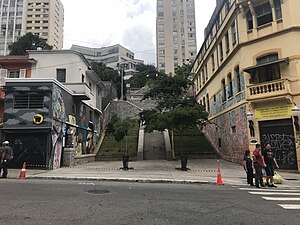
Bixiga
São Paulo neighborhood in Southeast, Brazil
Distance: Approx. 532 meters
Latitude and longitude: -23.55666667,-46.64472222
Bixiga is a neighbourhood in the center of the city of São Paulo, Brazil. It is located within the district of Bela Vista. Bixiga is known for having been a hub for Italian immigrants.
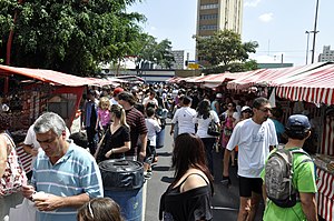
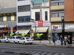
Liberdade street market
Distance: Approx. 375 meters
Latitude and longitude: -23.555202,-46.63598
The Liberdade Street Fair (Portuguese: Feira de Arte e Artesanato da Liberdade or Feirinha da Liberdade) is an art and handicraft fair in the Liberdade district of São Paulo. This popular open air market began in 1975 and operates every Saturday and Sunday from 9am to 6pm near the Liberdade Metro station. There is a number of attractions, festivals and other artistic events that occur all year along at the market.

Contando a féria
Sculpture in São Paulo, Brazil
Distance: Approx. 679 meters
Latitude and longitude: -23.55194444,-46.63444444
Portuguese: Contando a féria or The Shoemaker and the Newsboy (Portuguese: O engraxate e o jornaleiro) is a sculpture located in João Mendes Place in São Paulo, Brazil. It was created by Ricardo Cipicchia and inaugurated in 1950. The piece was produced in bronze, with a granite pedestal.

Historical Museum of Japanese Immigration in Brazil
Museum in São Paulo, Brazil
Distance: Approx. 726 meters
Latitude and longitude: -23.56083333,-46.63508333
The Historical Museum of Japanese Immigration in Brazil (Portuguese: Museu Histórico da Imigração Japonesa no Brasil) is located in the Liberdade neighborhood, in the city center of São Paulo, Brazil. It was inaugurated on June 18, 1978, by the Brazilian Society of Japanese Culture to celebrate the 70th anniversary of Japanese immigration to Brazil and has more than 97,000 historical items in its collection, including photos, films and videos. The opening ceremony was attended by the then Prince Akihito of Japan and the President of the Republic Ernesto Geisel.

Church and Convent of Saint Francis (São Paulo)
Catholic temple in São Paulo, Brazil
Distance: Approx. 719 meters
Latitude and longitude: -23.54972222,-46.63722222
The Church and Convent of Saint Francis was a religious institution installed in the town of São Paulo during colonial Brazil. In the 19th century, the convent was converted into a Law School. The Church of the Wounds of the Seraphic Father Saint Francis, built by the Secular Franciscan Order, is next to it.

Church of the Wounds of the Seraphic Father Saint Francis
Catholic temple in São Paulo, Brazil
Distance: Approx. 680 meters
Latitude and longitude: -23.55,-46.6375
The Church of the Wounds of the Seraphic Father Saint Francis of the Venerable Third Order of Saint Francis of Penance of São Paulo (Portuguese: Igreja das Chagas do Seráfico Pai São Francisco da Venerável Ordem Terceira de São Francisco da Penitência de São Paulo), usually known as the Church of the Wounds of the Seraphic Father Saint Francis (Igreja das Chagas do Seráfico Pai São Francisco), is a colonial temple located in Largo de São Francisco, in the historic center of São Paulo, Brazil. Along with the Church of Saint Francis, it composes a very important element in the layout of the old São Paulo de Piratininga. The building, inaugurated by the Third Order of Saint Francis in 1787, is the only architectural example remaining from the 18th century in the urban core of São Paulo.
Weather in this IP's area
clear sky
22 Celsius
23 Celsius
20 Celsius
22 Celsius
1019 hPa
77 %
1019 hPa
932 hPa
10000 meters
1.34 m/s
1.34 m/s
95 degree
06:10:14
17:58:20