Country:
Region:
City:
Latitude and Longitude:
Time Zone:
Postal Code:
IP information under different IP Channel
ip-api
Country
Region
City
ASN
Time Zone
ISP
Blacklist
Proxy
Latitude
Longitude
Postal
Route
Luminati
Country
ASN
Time Zone
America/Sao_Paulo
ISP
ALGAR TECNOLOGIA E CONSULTORIA SA
Latitude
Longitude
Postal
IPinfo
Country
Region
City
ASN
Time Zone
ISP
Blacklist
Proxy
Latitude
Longitude
Postal
Route
db-ip
Country
Region
City
ASN
Time Zone
ISP
Blacklist
Proxy
Latitude
Longitude
Postal
Route
ipdata
Country
Region
City
ASN
Time Zone
ISP
Blacklist
Proxy
Latitude
Longitude
Postal
Route
Popular places and events near this IP address

Brazilian Intelligence Agency
Distance: Approx. 3011 meters
Latitude and longitude: -15.821,-47.94
The Brazilian Intelligence Agency (Portuguese: Agência Brasileira de Inteligência, ABIN) is the main intelligence agency in Brazil. ABIN's mission is to ensure that the Federal Executive has access to knowledge related to the security of the State and society, such as those involving foreign defense, foreign relations, internal security, socioeconomic development and scientific-technological development.

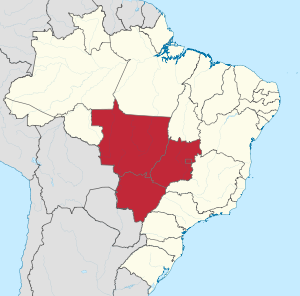
Central-West Region, Brazil
Region in Brazil
Distance: Approx. 4279 meters
Latitude and longitude: -15.77972222,-47.93055556
The Central-West or Center-West Region of Brazil (Portuguese: Região Centro-Oeste do Brasil [ʁeʒiˈɐ̃w ˌsẽtɾoˈɛstʃi du bɾaˈziw]) is composed of the states of Goiás, Mato Grosso and Mato Grosso do Sul; along with Distrito Federal (Federal District), where Brazil's national capital, Brasília, is situated. The region comprises 18.86% of the national territory, and is the least populated in Brazil. With the move of the country's federal capital from Rio de Janeiro to Brasília in the 1960s, the construction of roads and railways to the interior of the country made access to the region easier, speeding up population growth and contributing significantly to the region's development.

ParkShopping Brasília
Shopping mall in DF, Brazil
Distance: Approx. 3329 meters
Latitude and longitude: -15.83305556,-47.95527778
Park Shopping Brasília is a shopping center located in the Sector of Southwest Isolated Areas (SAISO), in the administrative region of Guará, in the Federal District, Brazil. It was inaugurated on November 8, 1983, being the 2nd shopping center to be inaugurated in the Federal District and located on the road between Guará and the Brasília, near the Interstate Bus Station of Brasília. It has 242 stores, including nine anchors (C & A, Fnac, Lojas Americanas, Riachuelo, Renner, Zara, Hot Zone, complex bowling Park Bowling and cinema complex ParkPlex group Severiano Ribeiro group and Paris Filmes), and five mega-stores (Ponto Frio, Livraria Siciliano, Centaur, Outback and Siberian).

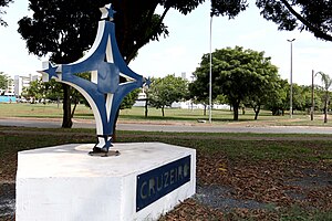
Cruzeiro, Federal District
Administrative region in Central-West, Brazil
Distance: Approx. 2993 meters
Latitude and longitude: -15.79083333,-47.93722222
Cruzeiro (Portuguese pronunciation: [kɾuˈzei.ɾu]) is an administrative region in the Federal District in Brazil. It is bordered by SIA and Brasília to the north, and Sudoeste/Octogonal to the southeast. Created in 1959, Cruzeiro is divided into two broad sections: the original town, Cruzeiro Velho, made up mostly of one- and two-story houses, and Cruzeiro Novo, made up of several similar four-story buildings since 1970.

Guará, Federal District
Administrative region in Central-West, Brazil
Distance: Approx. 3116 meters
Latitude and longitude: -15.82555556,-47.98
Guará (Portuguese pronunciation: [ɡuaˈɾa]) is an administrative region in the Federal District in Brazil. It is bordered by SIA to the north, Sudoeste/Octogonal and Candangolândia to the west, Núcleo Bandeirante to the south, Park Way to the southeast, and Águas Claras to the east, and Vicente Pires to the northeast. Guará was founded on May 5, 1969, receiving the status of administrative region, according to Law 49, of October 25, 1989.

Setor Complementar de Indústria e Abastecimento
Administrative region in Central-West, Brazil
Distance: Approx. 2564 meters
Latitude and longitude: -15.7875,-47.97861111
Setor Complementar de Indústria e Abastecimento is an administrative region in the Federal District in Brazil. It is bordered by Brasília to the north, SIA to the east and south, and Vicente Pires to the west. Setor Complementar de Indústria e Abastecimento was founded on October 25, 1989, receiving the status of administrative region, according to Law 3315, of January 27, 2004.

Setor de Indústria e Abastecimento
Administrative region in Central-West, Brazil
Distance: Approx. 182 meters
Latitude and longitude: -15.80388889,-47.96
Setor de Indústria e Abastecimento is an administrative region in the Federal District in Brazil. It is bordered by Brasília to the north and northeast, Cruzeiro and Sudoeste/Octogonal to the east, Guará and Vicente Pires to the south, and SCIA to the west. Setor de Indústria e Abastecimento is, alongside SCIA, an industrial hub in the Federal District, being host to various industries such as construction, logistics, and commerce.

Sudoeste/Octogonal
Administrative region in Central-West, Brazil
Distance: Approx. 4039 meters
Latitude and longitude: -15.80027778,-47.92416667
Sudoeste/Octogonal is an administrative region in the Federal District in Brazil. It is largely surrounded by Brasília to the east, and bordered by SIA and Cruzeiro to the west. Sudoeste/Octogonal was founded on July 10, 1989, receiving the status of administrative region, according to Law 3153, of May 6, 2003.
Terminal Asa Sul station
Federal District Metro station
Distance: Approx. 4835 meters
Latitude and longitude: -15.83708333,-47.93269444
Terminal Asa Sul is a Federal District Metro brazilian station on Orange and Green lines. It was opened on 31 March 2001 on the inaugural section of the line, from Central to Terminal Samambaia and Praça do Relógio. It is located between 114 Sul and Shopping.

Shopping station (Federal District Metro)
Federal District Metro station
Distance: Approx. 3399 meters
Latitude and longitude: -15.83241667,-47.95063889
Shopping (Station code: SHP) is a Federal District Metro station which is on the Orange and Green lines. It was opened on 31 March 2001 on the inaugural section of the line, from Central to Terminal Samambaia and Praça do Relógio. It is located between Terminal Asa Sul and Feira, near the Interstate Bus Terminal.
Feira station
Federal District Metro station
Distance: Approx. 2576 meters
Latitude and longitude: -15.82308333,-47.975
Feira or Feira do Guará (Station code: FEI) is a Federal District Metro Brazilian station on Orange and Green lines. It was opened on 31 March 2001 on the inaugural section of the line, from Central to Terminal Samambaia and Praça do Relógio. It is located between Shopping and Guará.
Guará station
Federal District Metro station
Distance: Approx. 3429 meters
Latitude and longitude: -15.82658333,-47.98325
Guará (Station code: GUA) is a Federal District Metro station operating on the Orange and Green lines. It was opened on 10 May 2010 and added to the already operating section of the line, from Central to Terminal Samambaia and Terminal Ceilândia. It is located between Feira and Arniqueiras.
Weather in this IP's area
light rain
20 Celsius
20 Celsius
19 Celsius
20 Celsius
1015 hPa
100 %
1015 hPa
893 hPa
10000 meters
1.03 m/s
80 degree
75 %
05:30:51
18:23:14
