Country:
Region:
City:
Latitude and Longitude:
Time Zone:
Postal Code:
IP information under different IP Channel
ip-api
Country
Region
City
ASN
Time Zone
ISP
Blacklist
Proxy
Latitude
Longitude
Postal
Route
Luminati
Country
Region
ba
City
livramentodobrumado
ASN
Time Zone
America/Bahia
ISP
WZNET TELECOM LTDA
Latitude
Longitude
Postal
IPinfo
Country
Region
City
ASN
Time Zone
ISP
Blacklist
Proxy
Latitude
Longitude
Postal
Route
db-ip
Country
Region
City
ASN
Time Zone
ISP
Blacklist
Proxy
Latitude
Longitude
Postal
Route
ipdata
Country
Region
City
ASN
Time Zone
ISP
Blacklist
Proxy
Latitude
Longitude
Postal
Route
Popular places and events near this IP address

Rio de Contas
Municipality of Bahia State, Brazil
Distance: Approx. 7851 meters
Latitude and longitude: -13.57888889,-41.81083333
Rio de Contas is a municipality in the Bahia state, in the eastern part of Brazil. Its estimated population as of 2020 was 12,932. Rio de Contas has its origins in the 18th century.
Roman Catholic Diocese of Livramento de Nossa Senhora
Catholic ecclesiastical territory
Distance: Approx. 909 meters
Latitude and longitude: -13.6502,-41.8411
The Roman Catholic Diocese of Livramento de Nossa Senhora (Latin: Dioecesis Liberationis Marianae) is a diocese located in the city of Livramento de Nossa Senhora (Bahia state) in the ecclesiastical province of Vitória da Conquista in Brazil.

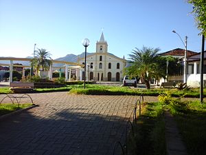
Livramento de Nossa Senhora
Municipality in Nordeste, Brazil
Distance: Approx. 222 meters
Latitude and longitude: -13.64277778,-41.84083333
Livramento de Nossa Senhora is a municipality in the state of Bahia in the North-East region of Brazil.
Weather in this IP's area
light rain
32 Celsius
32 Celsius
32 Celsius
32 Celsius
1013 hPa
40 %
1013 hPa
958 hPa
10000 meters
2.95 m/s
3.01 m/s
89 degree
68 %
05:12:12
17:49:36