186.189.52.229 - IP Lookup: Free IP Address Lookup, Postal Code Lookup, IP Location Lookup, IP ASN, Public IP
Country:
Region:
City:
Location:
Time Zone:
Postal Code:
IP information under different IP Channel
ip-api
Country
Region
City
ASN
Time Zone
ISP
Blacklist
Proxy
Latitude
Longitude
Postal
Route
Luminati
Country
City
oranjestad
ASN
Time Zone
America/Aruba
ISP
SERVICIO DI TELECOMUNICACION DI ARUBA SETAR N.V.
Latitude
Longitude
Postal
IPinfo
Country
Region
City
ASN
Time Zone
ISP
Blacklist
Proxy
Latitude
Longitude
Postal
Route
IP2Location
186.189.52.229Country
Region
aruba
City
babijn
Time Zone
America/Aruba
ISP
Language
User-Agent
Latitude
Longitude
Postal
db-ip
Country
Region
City
ASN
Time Zone
ISP
Blacklist
Proxy
Latitude
Longitude
Postal
Route
ipdata
Country
Region
City
ASN
Time Zone
ISP
Blacklist
Proxy
Latitude
Longitude
Postal
Route
Popular places and events near this IP address

Aruba
Dutch Caribbean island country
Distance: Approx. 4124 meters
Latitude and longitude: 12.5,-69.96666667
Aruba ( ə-ROO-bə, Dutch: [aːˈrubaː] or [aːˈrybaː] , Papiamento: [aˈruba]), officially the Country of Aruba (Dutch: Land Aruba; Papiamento: Pais Aruba), is a constituent island country within the Kingdom of the Netherlands, in the southern Caribbean Sea 29 kilometres (18 mi) north of the Venezuelan peninsula of Paraguaná and 80 kilometres (50 mi) northwest of Curaçao on the South-American continent. In 1986, Aruba became a constituent country within the Kingdom of the Netherlands and acquired the formal name the Country of Aruba. Aruba has an area of 179 km2 (69.1 sq mi).

Geography of Aruba
Distance: Approx. 4124 meters
Latitude and longitude: 12.5,-69.96666667
The geography of Aruba, located at the juncture of the South American and Caribbean tectonic plates, has been shaped by a complex interplay of geological processes. From its flat expanses to its rugged coastlines, Aruba's geography and geology reveal the island's geographical diversity and its underlying geological formations, offering a comprehensive understanding of Aruba's terrain and environmental dynamics of this Caribbean destination.
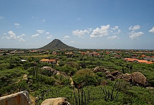
Hooiberg
Conical hill on Aruba
Distance: Approx. 2216 meters
Latitude and longitude: 12.517,-69.995
Hooiberg (Dutch: /ˈɦojbɛrx/ ()) is a distinctively shaped, 165 m (541 ft) conical hill located at the heart of the island of Aruba. This geological formation is a prominent and recognizable landmark that has long captured the attention of locals and visitors alike—Hooiberg is Aruba's centerpiece.

International School of Aruba
Distance: Approx. 3598 meters
Latitude and longitude: 12.50555556,-70.00027778
The International School of Aruba (ISA) is a non-profit private school in Aruba. In 2006, it moved to a new campus with a more centralized location. It was founded in 1929 and was owned by Lago Oil and Transport Co.

Casibari
Settlement in Aruba
Distance: Approx. 1403 meters
Latitude and longitude: 12.53027778,-69.99583333
Casibari is a settlement of Paradera, north of Hooiberg, in Aruba. Evidence of prehistoric rock drawings is still visible at the site. "Casibari" is an Indian name of Arawak (possibly Taíno) origin and can be explained as follows: CA as a prefix: where there are, SIBA (or CIBA) is stone and RI as a suffix is: good; so Where There are Good Stones.

Aureus University School of Medicine
Medical school in Aruba
Distance: Approx. 3893 meters
Latitude and longitude: 12.50674444,-70.00660556
Aureus University School of Medicine (previously named as All Saints University of Medicine) is a private university located in Oranjestad, Aruba. Aureus confers upon its graduates the Doctor of Medicine (MD) degree.

Santa Cruz, Aruba
Town and region in Santa Cruz, Aruba
Distance: Approx. 4124 meters
Latitude and longitude: 12.5,-69.96666667
Santa Cruz is a Region and Town in central Aruba, dominated by the Arikok National Park. The town is connected by Highway 7 from west to east and Highway 4 from north to south. The district has an area of 41.04 square kilometers and 12,870 inhabitants according to the 2010 census.
Museum of Antiquities Aruba
Distance: Approx. 3341 meters
Latitude and longitude: 12.5384,-70.0136
The Museum of Antiquities Aruba (Papiamento: Museo di Antiguedad Aruba) is a museum in Paradera in the outskirts of Oranjestad in Aruba. The museum covers from the preceramic era to the 20th century.

Aruba Natural Bridge
Distance: Approx. 2849 meters
Latitude and longitude: 12.54111111,-69.95833333
The Aruba Natural Bridge was a tourist attraction in Arikok National Park, Aruba that was formed naturally out of coral limestone. It collapsed on 2 September 2005. The natural arch, measuring approximately 25 feet (7.6 m) high and 100 feet (30 m) long, was the remnant of an ancient cave.
St. Philomena's Church, Paradera
Church in Aruba, Netherlands
Distance: Approx. 2296 meters
Latitude and longitude: 12.5356,-70.0043
The St. Philomena's Church (Papiamento: Parokia Santa Filomena Dutch: St. Filomenakerk) is a religious building belonging to the Catholic Church located in the town of Paradera, on the Caribbean island of Aruba, an autonomous country in the Kingdom of the Netherlands in the Lesser Antilles.
Paradera
Region in Aruba, Kingdom of the Netherlands
Distance: Approx. 1815 meters
Latitude and longitude: 12.53333333,-70
Paradera is a small town and census region near the northeast end of the island of Aruba. The census region Paradera encompasses the town of Paradera as well as nearby settlements and neighborhoods within Paradera, including Ayo, Bloemond, Piedra Plat, and Shiribana. At the time of the 2010 census, Paradera proper had a population of 2,486.
Tanki Leendert
Place in Aruba, Kingdom of the Netherlands
Distance: Approx. 4082 meters
Latitude and longitude: 12.5416,-70.01989
Tanki Leendert is a town in Noord on the island of Aruba.
Weather in this IP's area
light rain
27 Celsius
30 Celsius
27 Celsius
27 Celsius
1014 hPa
83 %
1014 hPa
1009 hPa
10000 meters
6.17 m/s
70 degree
20 %


