186.189.215.68 - IP Lookup: Free IP Address Lookup, Postal Code Lookup, IP Location Lookup, IP ASN, Public IP
Country:
Region:
City:
Location:
Time Zone:
Postal Code:
IP information under different IP Channel
ip-api
Country
Region
City
ASN
Time Zone
ISP
Blacklist
Proxy
Latitude
Longitude
Postal
Route
Luminati
Country
Region
01
City
guatemalacity
ASN
Time Zone
America/Guatemala
ISP
Navega.com S.A.
Latitude
Longitude
Postal
IPinfo
Country
Region
City
ASN
Time Zone
ISP
Blacklist
Proxy
Latitude
Longitude
Postal
Route
IP2Location
186.189.215.68Country
Region
retalhuleu
City
san sebastian
Time Zone
ISP
Language
User-Agent
Latitude
Longitude
Postal
db-ip
Country
Region
City
ASN
Time Zone
ISP
Blacklist
Proxy
Latitude
Longitude
Postal
Route
ipdata
Country
Region
City
ASN
Time Zone
ISP
Blacklist
Proxy
Latitude
Longitude
Postal
Route
Popular places and events near this IP address
Retalhuleu
Municipality and city in Guatemala
Distance: Approx. 5167 meters
Latitude and longitude: 14.53333333,-91.68333333
The city of Retalhuleu (Spanish pronunciation: [retaluˈlew]) is situated in south-western Guatemala. It is the departmental seat of Retalhuleu Department as well as the municipal seat of Retalhuleu Municipality. Retalhuleu stands at about 240 metres above sea level.

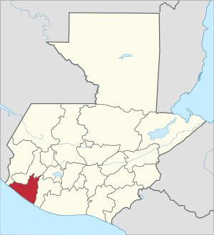
Retalhuleu Department
Department of Guatemala
Distance: Approx. 4639 meters
Latitude and longitude: 14.5353,-91.6783
Retalhuleu (Spanish pronunciation: [retaluˈlew]) is a department located in the south-west of Guatemala, extending from the mountains to the Pacific Ocean coast. It has an area of 1856 km2. In 2018 the population of the Department of Retalhuleu was 326,828.

Santa Cruz Muluá
Distance: Approx. 4040 meters
Latitude and longitude: 14.58333333,-91.61666667
Santa Cruz Muluá is a municipality in the Retalhuleu department of Guatemala. Its name comes from the ancient mayan word " Mulaja " which means " Land Between Rivers, " because its between the Samalá River, the Rio Muluá and many other small rivers and streams. It is situated 180 km from Guatemala City.
Nuevo San Carlos
Municipality in Retalhuleu Department, Guatemala
Distance: Approx. 6539 meters
Latitude and longitude: 14.6,-91.7
Nuevo San Carlos is a town, with a population of 22,657 (2018 census), and a municipality in the Retalhuleu department of Guatemala.
San Andrés Villa Seca
Municipality in Retalhuleu, Guatemala
Distance: Approx. 7183 meters
Latitude and longitude: 14.56666667,-91.58333333
San Andrés Villa Seca is a town and municipality in the Retalhuleu Department of Guatemala.
San Felipe, Retalhuleu
Municipality in Retalhuleu, Guatemala
Distance: Approx. 8345 meters
Latitude and longitude: 14.62055556,-91.59611111
San Felipe is a town, with a population of 17,360 (2018 census), and a municipality in Retalhuleu Department, situated on the road to Quetzaltenango between El Palmar, Quetzaltenango to the north-west and San Martin Zapotitlan to the south side.
San Sebastián, Retalhuleu
Municipality in Retalhuleu Department, Guatemala
Distance: Approx. 4 meters
Latitude and longitude: 14.56666667,-91.65
San Sebastián is a town and municipality in the Retalhuleu department of Guatemala.
Retalhuleu Airport
Airport in Retalhuleu, Guatemala
Distance: Approx. 7186 meters
Latitude and longitude: 14.52111111,-91.69722222
Retalhuleu Airport (IATA: RER, ICAO: MGRT), also known as Base Aérea del Sur, is an airport serving Retalhuleu, the capital of Retalhuleu Department in Guatemala. The Retalhuleu non-directional beacon (Ident: REU) is located on the field.

Xetulul Theme Park
Theme park in Guatemala
Distance: Approx. 5176 meters
Latitude and longitude: 14.59472222,-91.61166667
Xetulul is a theme park in Guatemala. It is located in the Retalhuleu Department in the southwest of the country. Opening in 2002, Xetulul is the third-largest amusement park in Latin America, after Beto Carrero World in Penha, Santa Catarina, Brazil and Six Flags México near Mexico City, Mexico.

Xocomil
Water park in Guatemala
Distance: Approx. 5545 meters
Latitude and longitude: 14.5984,-91.6103
Xocomil is a water park in Guatemala. It is located in the Retalhuleu Department in the southwest of the country. It is the largest and most-visited water park in the country.
El Tambor River
River in Guatemala
Distance: Approx. 6701 meters
Latitude and longitude: 14.61624,-91.61466
The El Tambor River is a river of Guatemala. It is a tributary of the Samalá River.

Estadio Dr. Óscar Monterroso Izaguirre
Distance: Approx. 4435 meters
Latitude and longitude: 14.54,-91.68055556
Estadio Dr. Óscar Monterroso Izaguirre, is a multi-purpose stadium in Retalhuleu, Guatemala. It is mainly used mostly for football matches and hosts the home matches of Deportivo Reu of the Guatemalan Primera División de Ascenso.
Weather in this IP's area
clear sky
26 Celsius
24 Celsius
26 Celsius
26 Celsius
1014 hPa
1 %
1014 hPa
961 hPa
10000 meters
1.02 m/s
0.97 m/s
213 degree
2 %