Country:
 Venezuela
Region:
City:
Latitude and Longitude:
Time Zone:
Postal Code:
IP information under different IP Channel
ip-api
Country
Region
City
ASN
Time Zone
ISP
Blacklist
Proxy
Latitude
Longitude
Postal
Route
IPinfo
Country
Region
City
ASN
Time Zone
ISP
Blacklist
Proxy
Latitude
Longitude
Postal
Route
MaxMind
Country
Region
City
ASN
Time Zone
ISP
Blacklist
Proxy
Latitude
Longitude
Postal
Route
Luminati
Country
VERegion
s
City
sancristobal
ASN
Time Zone
America/Caracas
ISP
TELEFONICA VENEZOLANA, C.A.
Latitude
Longitude
Postal
db-ip
Country
Region
City
ASN
Time Zone
ISP
Blacklist
Proxy
Latitude
Longitude
Postal
Route
ipdata
Country
Region
City
ASN
Time Zone
ISP
Blacklist
Proxy
Latitude
Longitude
Postal
Route
Popular places and events near this IP address

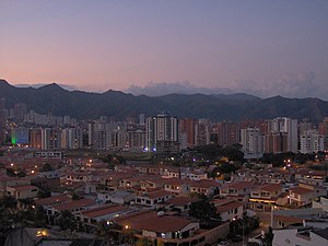
Valencia, Venezuela
Place in Carabobo, Venezuela
Distance: Approx. 6793 meters
Latitude and longitude: 10.18333333,-68
Valencia (Spanish pronunciation: [baˈlensja]) is the capital city of Carabobo State and the third-largest city in Venezuela. The city is an economic hub that contains Venezuela's top industries and manufacturing companies. It is also the largest city in the Valencia-Maracay metropolitan region, which with a population of about 4.5 million is the country's second largest after that of Caracas.

Carabobo
State of Venezuela
Distance: Approx. 4587 meters
Latitude and longitude: 10.193,-67.98
Carabobo State (Spanish: Estado Carabobo, IPA: [esˈtaðo kaɾaˈβoβo]) is one of the 23 states of Venezuela, located in the north of the country, about two hours by car from Caracas. The state capital city is Valencia, which is also the country's main industrial center. The state's area is 4,369 km2 (1,687 sq mi) and as of the 2011 census, had a population of 2,245,744.

Arturo Michelena International Airport
Airport in Valencia, Carabobo
Distance: Approx. 4524 meters
Latitude and longitude: 10.15,-67.92777778
Arturo Michelena International Airport (IATA: VLN, ICAO: SVVA) is an airport serving the city of Valencia in Venezuela. The airport was named after artist Arturo Michelena, who was born in Valencia. It is a hub for Turpial Airlines and was once a secondary hub for Avior Airlines.

Forum de Valencia
Indoor sporting arena in Valencia, Carabobo, Venezuela
Distance: Approx. 7974 meters
Latitude and longitude: 10.220228,-68.00395
Forum de Valencia is an indoor sporting arena located in the Venezuelan city of Valencia, Carabobo. The capacity of the arena is 10,000 and is used mostly for basketball and concerts.
Estadio José Bernardo Pérez
Distance: Approx. 4806 meters
Latitude and longitude: 10.1756,-67.9799
Estadio José Bernardo Pérez is a multi-use stadium in Valencia, Venezuela. It opened on October 8, 1955, and holds 15,500 people. Originally named Estadio Cuatricentenario, it primarily served as the home stadium for the Industriales de Valencia baseball club.
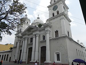
Roman Catholic Archdiocese of Valencia in Venezuela
Roman Catholic archdiocese in Venezuela
Distance: Approx. 7075 meters
Latitude and longitude: 10.1825,-68.0025
The Roman Catholic Archdiocese of Valencia en Venezuela (Latin: Archidioecesis Valentinus in Venetiola) is an archdiocese located in the city of Valencia in Venezuela.
Los Guayos
Place
Distance: Approx. 859 meters
Latitude and longitude: 10.18333333,-67.93333333
Los Guayos is a town in Carabobo State, Venezuela, northwest of the Valencia Lake. It is the capital of the Los Guayos Municipality and is part of Valencia's metropolitan area.

Valencia Aquarium
Zoo in Valencia, Venezuela
Distance: Approx. 7917 meters
Latitude and longitude: 10.18888889,-68.01055556
Valencia Aquarium (officially Acuario de Valencia, Fundación Seijas) is a recreational park located in Valencia, Venezuela. It is the largest aquarium in Venezuela, and it also has a small zoo with species from Venezuela. It is operated by the J.V. Seijas Foundation.

Universidad Tecnológica del Centro
Distance: Approx. 7090 meters
Latitude and longitude: 10.2058,-67.8758
The Center Technological University (UNITEC) (Spanish: Universidad Tecnológica del Centro) is a private university located in Carabobo, Venezuela. Its academic activities began in August 1981 in Guacara. The UNITEC college also has a campus in Valencia.
2018 Valencia, Venezuela fire
Prison fire in Valencia, Venezuela
Distance: Approx. 7003 meters
Latitude and longitude: 10.189222,-68.002216
On 28 March 2018, a fire broke out during a prison riot in the cells at the Carabobo state police headquarters in Valencia, Carabobo, Venezuela. The fire killed at least 68 people and injured scores of others. The fire is one of the deadliest incidents ever in a Venezuelan prison since the 1994 Sabaneta prison fire, in which more than 100 inmates died.

Camoruco railway station
Railroad station in Valencia, Venezuela
Distance: Approx. 7959 meters
Latitude and longitude: 10.2004849,-68.0100513
The Camoruco railway terminus (Spanish: Estación Camoruco del Ferrocarril) in Valencia, Venezuela, is a rare survival of a 19th-century railway station in the South America country. The building is also known as the Rectorado of the University of Carabobo. When the Puerto Cabello and Valencia railway closed in the 1950s, the station was transferred to the University of Carabobo which converted it for administrative use.

Francisco de Miranda station (Valencia)
Valencia metro station
Distance: Approx. 7601 meters
Latitude and longitude: 10.2013,-68.0066
Francisco de Miranda station (Spanish: Estación Francisco de Miranda), also known as Rectorado station, is one of the stations of the Valencia Metro in Venezuela.
Weather in this IP's area
broken clouds
24 Celsius
24 Celsius
24 Celsius
24 Celsius
1014 hPa
73 %
1014 hPa
965 hPa
10000 meters
1.5 m/s
2.51 m/s
165 degree
75 %
06:20:04
18:19:07