Country:
 Peru
PeruRegion:
City:
Latitude and Longitude:
Time Zone:
Postal Code:
IP information under different IP Channel
ip-api
Country
Region
City
ASN
Time Zone
ISP
Blacklist
Proxy
Latitude
Longitude
Postal
Route
IPinfo
Country
Region
City
ASN
Time Zone
ISP
Blacklist
Proxy
Latitude
Longitude
Postal
Route
MaxMind
Country
Region
City
ASN
Time Zone
ISP
Blacklist
Proxy
Latitude
Longitude
Postal
Route
Luminati
Country
PEASN
Time Zone
America/Lima
ISP
ENTEL PERU S.A.
Latitude
Longitude
Postal
db-ip
Country
Region
City
ASN
Time Zone
ISP
Blacklist
Proxy
Latitude
Longitude
Postal
Route
ipdata
Country
Region
City
ASN
Time Zone
ISP
Blacklist
Proxy
Latitude
Longitude
Postal
Route
Popular places and events near this IP address

Historic Centre of Lima
World Heritage Site in Peru
Distance: Approx. 556 meters
Latitude and longitude: -12.05138889,-77.04305556
The Historic Centre of Lima (Spanish: Centro histórico de Lima) is the historic city centre of the city of Lima, the capital of Peru. Located in the city's districts of Lima and Rímac, both in the Rímac Valley, it consists of two areas: the first is the Monumental Zone established by the Peruvian government in 1972, and the second one—contained within the first one—is the World Heritage Site established by UNESCO in 1988, whose buildings are marked with the organisation's black-and-white shield. Founded on January 18, 1535, by Conquistador Francisco Pizarro, the city served as the political, administrative, religious and economic capital of the Viceroyalty of Peru, as well as the most important city of Spanish South America.
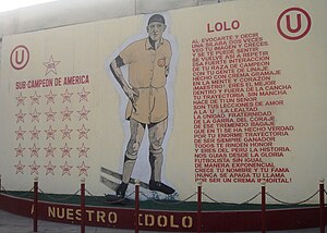
Estadio Teodoro Lolo Fernández
Distance: Approx. 573 meters
Latitude and longitude: -12.0489,-77.0474
Estadio Teodoro Lolo Fernández is a stadium in Lima, Peru, built in the 1950s and opened on July 20, 1952. It is owned by the football club Universitario de Deportes, being their first stadium; one stand in the west for 4,000 spectators brought from the Estadio Nacional. The inauguration game saw Universitario play Universidad de Chile where they won 4-2; Lolo Fernández scored three goals.

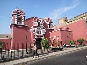
Sanctuary and Monastery of Las Nazarenas
Distance: Approx. 599 meters
Latitude and longitude: -12.04556389,-77.03736694
The Sanctuary and Monastery of Las Nazarenas is a church in Lima and is the site of the Peruvian Catholic procession of the Lord of Miracles, Señor de los Milagros, who is also the patron of the city. It was constructed together with the Monastery of Nazarenas, after a major earthquake it was finally completed in 1771. From this church begins America's most important religious procession on October 18 and 28.

Plaza Dos de Mayo
Cultural heritage site in Peru
Distance: Approx. 3 meters
Latitude and longitude: -12.04638889,-77.04277778
The Dos de Mayo Square (Spanish: Plaza Dos de Mayo), known as the Óvalo de la Reina until 1866, is a public square located in Lima, Peru. Located on the southwestern edge of the historic centre's bufferzone, it serves as the junction of several important avenues, including Alfonso Ugarte, La Colmena and Colonial avenues. In the late 20th century, a vehicular tunnel was built under the square to curb traffic congestions.

Hotel Crillón (Lima)
Former hotel in Peru
Distance: Approx. 591 meters
Latitude and longitude: -12.04923118,-77.03820694
Crillón Building (Spanish: Edificio Crillón) is an office building located at Nicolás de Piérola Avenue in the Historic Centre of Lima, Peru. From 1947 until 1999, it hosted the Hotel Crillón, one of the city's most emblematic hotels, hosting well-known figures of the era, including foreign actors and musicians.

Plaza Ramón Castilla
Cultural heritage site in Peru
Distance: Approx. 335 meters
Latitude and longitude: -12.0434,-77.043
Ramón Castilla Square (Spanish: Plaza Ramón Castilla), formerly known as Union Square (Spanish: Plaza Unión), is a public square in the historic centre of Lima, Peru. It is one of three squares through which Alfonso Ugarte Avenue passes—the others being Dos de Mayo and Bolognesi—and is also located at the intersection of Argentina and Emancipación avenues. It is named after former president Ramón Castilla.
St. Sebastian's Church, Lima
Church in Lima, Peru
Distance: Approx. 734 meters
Latitude and longitude: -12.0438,-77.0366
St. Sebastian's Church (Spanish: Iglesia de San Sebastián) is a Catholic church in the historic centre of Lima in the corners of Ica and Chancay streets, one block from Tacna Avenue, in the old neighbourhood of Monserrate (then Cuartel Primero). Its pink and white front faces Jirón Ica.

Puente del Ejército
Bridge in Lima, Peru
Distance: Approx. 849 meters
Latitude and longitude: -12.0388,-77.0434
The Army Bridge (Spanish: Puente del Ejército) is a tied-arch bridge that crosses Rímac River in the limits of Rímac and San Martín de Porres districts of Lima, Peru. It joins Alfonso Ugarte Avenue to the south with Caquetá Avenue (former Pan-American Highway) to the north. It was inaugurated on December 31, 1936, under then president Óscar R. Benavides, and was later remodelled in the 1950s, under the presidency of Manuel A. Odría.

National Museum of Peruvian Culture
Museum in Peru
Distance: Approx. 168 meters
Latitude and longitude: -12.0479,-77.043
The National Museum of Peruvian Culture (Spanish: Museo Nacional de la Cultura Peruana), formerly the National Archaeology Museum (Spanish: Museo de Arqueología Nacional), is a museum dedicated to Peruvian culture in Lima, Peru.
Municipal Theatre Museum
Museum in Peru
Distance: Approx. 838 meters
Latitude and longitude: -12.0464,-77.0351
The Municipal Theatre Museum (Spanish: Museo Municipal de Teatro) is a museum in the historic centre of Lima, Peru. Formerly located on the first floor of the Teatro Segura, it is currently located on Jirón Huancavelica 338, behind the theatre.
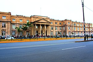
Archbishop Loayza National Hospital
Hospital in Peru
Distance: Approx. 384 meters
Latitude and longitude: -12.049831,-77.043139
Archbishop Loayza National Hospital (Spanish: Hospital Nacional Arzobispo Loayza, HNAL) is a public hospital located in Lima, Peru. It is administered by the Ministry of Health. It was founded by the first archbishop of Peru, Gerónimo de Loayza in 1549 as Saint Anne's Hospital (Spanish: Hospital de Santa Ana), which provided health services to the indigenous population and poor women.

Cine Tauro
Former cinema in Peru
Distance: Approx. 552 meters
Latitude and longitude: -12.0506,-77.0401
The Cine Tauro is a defunct movie theatre built in 1959 by Peruvian architect Walter Weberhofer. The building is located in the district of Lima. Since the 1990s, the theatre has started showing pornographic films and has been temporarily closed on several occasions.
Weather in this IP's area
broken clouds
17 Celsius
17 Celsius
17 Celsius
21 Celsius
1013 hPa
72 %
1013 hPa
996 hPa
10000 meters
4.63 m/s
300 degree
75 %
05:58:48
18:04:09