Country:
 Chile
ChileRegion:
City:
Latitude and Longitude:
Time Zone:
Postal Code:
IP information under different IP Channel
ip-api
Country
Region
City
ASN
Time Zone
ISP
Blacklist
Proxy
Latitude
Longitude
Postal
Route
IPinfo
Country
Region
City
ASN
Time Zone
ISP
Blacklist
Proxy
Latitude
Longitude
Postal
Route
MaxMind
Country
Region
City
ASN
Time Zone
ISP
Blacklist
Proxy
Latitude
Longitude
Postal
Route
Luminati
Country
CLRegion
rm
City
loprado
ASN
Time Zone
America/Santiago
ISP
VTR BANDA ANCHA S.A.
Latitude
Longitude
Postal
db-ip
Country
Region
City
ASN
Time Zone
ISP
Blacklist
Proxy
Latitude
Longitude
Postal
Route
ipdata
Country
Region
City
ASN
Time Zone
ISP
Blacklist
Proxy
Latitude
Longitude
Postal
Route
Popular places and events near this IP address

Cerro Navia
Commune in Santiago Metropolitan Region, Chile
Distance: Approx. 2537 meters
Latitude and longitude: -33.42,-70.73333333
Cerro Navia (Spanish for "Navia Hill") is a commune of Chile located in Santiago Province, Santiago Metropolitan Region. It is one of the most densely populated communes of Santiago, Chile.

Lo Prado
City and Commune in Santiago Metro., Chile
Distance: Approx. 924 meters
Latitude and longitude: -33.45,-70.725
Lo Prado (Spanish pronunciation: [lo ˈpɾaðo]) is a Chilean commune located in Santiago, which is itself part of the Metropolitan region of Chile. It is part of the Greater Santiago urban area.

Quinta Normal
City and Commune in Santiago Metro, Chile
Distance: Approx. 2758 meters
Latitude and longitude: -33.42833333,-70.7
Quinta Normal is a commune of Chile located in Santiago Province, Santiago Metropolitan Region. It is named after a large park in the area.

San Pablo metro station
Santiago metro station
Distance: Approx. 437 meters
Latitude and longitude: -33.44530833,-70.72313889
San Pablo is a rapid transit complex in the Santiago Metro, located in Lo Prado. Lines 1 and 5 stop there, being the western terminus of the former. Opening on 15 September 1975 for the Line 1, as part of the inaugural section of the line between San Pablo and La Moneda, San Pablo is one of the oldest stations in the system, and the Line 1 station is the only one in the system that is located partly underground and partly at surface level.
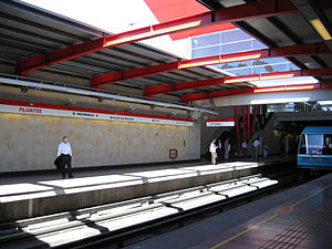
Pajaritos metro station
Santiago metro station
Distance: Approx. 1938 meters
Latitude and longitude: -33.45739444,-70.71597778
Pajaritos is a metro station on the Line 1 of the Santiago Metro, in Santiago, Chile. Ruta 68 and General Bonilla Avenue run parallel to the station. The station was opened on 15 September 1975 as part of the inaugural section of the line between San Pablo and La Moneda.

Neptuno metro station
Santiago metro station
Distance: Approx. 1113 meters
Latitude and longitude: -33.45150833,-70.72267778
Neptuno is a metro station on the Line 1 of the Santiago Metro, in Santiago, Chile. It is located close to the main maintenance facility for the Metro of Santiago. It has a moderate-low flow of passengers, located in a residential place with no big attractions.

Lo Prado metro station
Santiago metro station
Distance: Approx. 776 meters
Latitude and longitude: -33.44316111,-70.71682778
Lo Prado is an underground metro station on the Line 5 of the Santiago Metro, in Santiago, Chile. The entrance to the station is located in front of the town hall of Lo Prado. The station was opened on 12 January 2010 as part of the extension of the line from Quinta Normal to Pudahuel.

Las Rejas metro station
Santiago metro station
Distance: Approx. 2499 meters
Latitude and longitude: -33.45722222,-70.70555556
Las Rejas is an underground metro station on the Line 1 of the Santiago Metro, in Santiago, Chile. It was built in cut-and-cover method. The station was opened on 15 September 1975 as part of the inaugural section of the line between San Pablo and La Moneda.

Blanqueado metro station
Santiago metro station
Distance: Approx. 1689 meters
Latitude and longitude: -33.44111944,-70.70682778
Blanqueado is an underground metro station on the Line 5 of the Santiago Metro, in Santiago, Chile. The station was opened on 12 January 2010 as part of the extension of the line from Quinta Normal to Pudahuel. The tunnel containing the platforms, which are 135 metres (443 ft) long, is connected by a concourse tunnel to a large shaft, which includes the ticket hall, as well as the stairways and elevator that lead to the only exit.

Laguna Sur metro station
Santiago metro station
Distance: Approx. 2593 meters
Latitude and longitude: -33.46235278,-70.73791944
Laguna Sur station is an underground metro station on the Line 5 of Santiago Metro network, in Santiago, Chile. It is located underneath the junction of Teniente Cruz Avenue with Laguna Sur Street, in the commune of Pudahuel between Las Parcelas station (1,140 meters away) and Barrancas station (1,140 meters away). The station was opened on 3 February 2011 as part of the extension of the line from Pudahuel to Plaza de Maipú.

Pudahuel metro station
Santiago metro station
Distance: Approx. 1534 meters
Latitude and longitude: -33.44494167,-70.74105278
Pudahuel is a rapid transit station on the Line 5. It is located underneath the junction of San Pablo Avenue and Teniente Cruz Avenue, underneath the border of Pudahuel and Lo Prado. The station was opened on January 12, 2010 by president Michelle Bachelet, as part of the lLine's extension from Quinta Normal to Pudahuel, and was the Line's western terminus until 3 February 2011 when the line was extended southwest towards Plaza de Maipú.

Barrancas metro station
Santiago metro station
Distance: Approx. 1830 meters
Latitude and longitude: -33.45291111,-70.73941111
Barrancas is an underground metro station on Line 5 of the Santiago Metro network in Santiago, Chile. It is located underneath the junction of Teniente Cruz Avenue and General Bonilla Avenue on the border of the communes of Pudahuel and Lo Prado, between Laguna Sur station (1140 meters away) and Pudahuel station (990 meters away). It also lies parallel to the Route 68 highway which connects Santiago with Valparaíso and Viña del Mar, and the highway crosses over the underground metro line.
Weather in this IP's area
overcast clouds
18 Celsius
17 Celsius
16 Celsius
20 Celsius
1014 hPa
51 %
1014 hPa
956 hPa
10000 meters
1.48 m/s
1.17 m/s
220 degree
100 %
07:34:28
19:37:56