Country:
 Chile
ChileRegion:
City:
Latitude and Longitude:
Time Zone:
Postal Code:
IP information under different IP Channel
ip-api
Country
Region
City
ASN
Time Zone
ISP
Blacklist
Proxy
Latitude
Longitude
Postal
Route
IPinfo
Country
Region
City
ASN
Time Zone
ISP
Blacklist
Proxy
Latitude
Longitude
Postal
Route
MaxMind
Country
Region
City
ASN
Time Zone
ISP
Blacklist
Proxy
Latitude
Longitude
Postal
Route
Luminati
Country
CLRegion
ta
City
iquique
ASN
Time Zone
America/Santiago
ISP
VTR BANDA ANCHA S.A.
Latitude
Longitude
Postal
db-ip
Country
Region
City
ASN
Time Zone
ISP
Blacklist
Proxy
Latitude
Longitude
Postal
Route
ipdata
Country
Region
City
ASN
Time Zone
ISP
Blacklist
Proxy
Latitude
Longitude
Postal
Route
Popular places and events near this IP address

Iquique Province
Province in Tarapacá, Chile
Distance: Approx. 1281 meters
Latitude and longitude: -20.21388889,-70.1525
Iquique Province (Spanish: Provincia de Iquique) is one of two provinces in the northern Chilean region of Tarapacá. Its capital is the port city of Iquique.
Arturo Prat University
Distance: Approx. 2292 meters
Latitude and longitude: -20.24361111,-70.14138889
Universidad Arturo Prat is a university in Chile. It is a derivative university part of the Chilean Traditional Universities. The university was created in 1981 from the former campus of the University of Chile in Iquique.

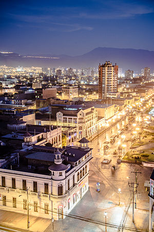
Iquique
City and Commune in Tarapacá, Chile
Distance: Approx. 879 meters
Latitude and longitude: -20.21666667,-70.15
Iquique (Spanish pronunciation: [iˈkike]) is a port city and commune in northern Chile, capital of both the Iquique Province and Tarapacá Region. It lies on the Pacific coast, west of the Pampa del Tamarugal, which is part of the Atacama Desert. It has a population of 191,468 according to the 2017 census.

Alto Hospicio
Commune in Tarapacá, Chile
Distance: Approx. 4231 meters
Latitude and longitude: -20.25,-70.11666667
Alto Hospicio is a Chilean municipality and commune located next to Iquique, in the Iquique Province, Tarapacá Region. It is a fast-growing popular area in the heights of Iquique and has a population of 94,254 according to the preliminary result of the 2012 census. It is the second largest commune of the Greater Iquique urbanization with a total population of 275,000 in 2012.
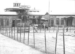
Santa María School massacre
1907 massacre of mine workers in Chile
Distance: Approx. 643 meters
Latitude and longitude: -20.2178,-70.1471
The Santa María School massacre was a massacre of striking workers, mostly saltpeter works (nitrate) miners, along with wives and children, committed by the Chilean Army in Iquique, Chile, on December 21, 1907. The number of victims is undetermined but is estimated to be over 2,000. The massacre occurred during the peak of the nitrate mining era, which coincided with the Parliamentary Period in Chilean political history (1891–1925).
Roman Catholic Diocese of Iquique
Catholic ecclesiastical territory
Distance: Approx. 1374 meters
Latitude and longitude: -20.2118,-70.1501
The Roman Catholic Diocese of Iquique (Latin: Iquiquen(sis)) is a diocese located in the city of Iquique, Chile, in the ecclesiastical province of Antofagasta.
Estadio Tierra de Campeones
Stadium in Iquique, Chile
Distance: Approx. 2496 meters
Latitude and longitude: -20.242413,-70.132937
Estadio Tierra de Campeones is an athletics and football stadium in Iquique, Tarapaca Region, Chile. It is the home stadium of Deportes Iquique. The stadium which was built in 1993, was demolished in 2016, and re-opened in 2020.
Baquedano Street
Street in Iquique, Chile
Distance: Approx. 1280 meters
Latitude and longitude: -20.2139,-70.1525
Baquedano Street (Spanish: Calle Baquedano; Paseo Baquedano), originally known as Santa Rosa Street (Spanish: Calle Santa Rosa) and then as Huancavelica Street (Spanish: Calle Huancavelica) prior to 1883, is a long avenue in the old quarter of Iquique, Chile. It is a popular tourist attraction and is a "typical zone" (Spanish: Zona típica), a status that preserves its historical and architectural heritage. It is characterized by its late 19th and early 20th-century houses built of wood from Europe.

Battle of Iquique
1879 naval battle during the War of the Pacific
Distance: Approx. 2655 meters
Latitude and longitude: -20.2016,-70.1559
The Battle of Iquique was a naval engagement on 21 May 1879, during the War of the Pacific, where a Chilean corvette commanded by Arturo Prat Chacón faced a Peruvian ironclad under Miguel Grau Seminario. The battle occurred off the port of Iquique, Peru, and ended with the sinking of the Chilean wooden corvette Esmeralda by the Peruvian ironclad Huáscar after four hours of combat, marking a victory for Peru.

Zona Franca of Iquique
Distance: Approx. 2207 meters
Latitude and longitude: -20.207075,-70.13360833
The Zona Franca de Iquique, known by the acronym Zofri (in English Free Zone of Iquique), is located in the coastal port city of Iquique, in Iquique Province of the Tarapacá Region, northwestern Chile.

Clock Tower (Iquique)
Distance: Approx. 1255 meters
Latitude and longitude: -20.21416667,-70.1525
The Clock Tower is a National Historic Landmark located in Plaza Arturo Prat in Iquique, Chile. It was built in 1878 (when Iquique was in Peruvian territory), with the mechanism imported from England. According to Patricio Advis, the Clock Tower, together with the buildings surrounding it in the plaza (the Municipal Theater of Iquique, the building of the Workers Welfare Society of Tarapacá, the Casino Español and the Club Croata) is one of the most representative urban expressions of the "Saltpeter Period", a time which saw much foreign investment.

Immaculate Conception Cathedral, Iquique
Church in Iquique, Chile
Distance: Approx. 1350 meters
Latitude and longitude: -20.2119,-70.1497
The Immaculate Conception Cathedral (Spanish: Catedral de la Inmaculada Concepción) also called Iquique Cathedral It is a cathedral church of Catholic worship, home of the Roman Catholic Diocese of Iquique in the northern part of the South American country of Chile. It was consecrated in 1882 under the patronage of the Immaculate Conception of Mary. It was built thanks to the fund campaign initiated by the Apostolic Vicar Camilo Ortuzar, after the parish church of Iquique was destroyed by fire on May 10, 1833.
Weather in this IP's area
few clouds
18 Celsius
18 Celsius
18 Celsius
18 Celsius
1011 hPa
65 %
1011 hPa
1008 hPa
10000 meters
1.44 m/s
2.07 m/s
234 degree
14 %
07:31:36
19:36:10