Country:
 Colombia
Region:
City:
Latitude and Longitude:
Time Zone:
Postal Code:
IP information under different IP Channel
ip-api
Country
Region
City
ASN
Time Zone
ISP
Blacklist
Proxy
Latitude
Longitude
Postal
Route
IPinfo
Country
Region
City
ASN
Time Zone
ISP
Blacklist
Proxy
Latitude
Longitude
Postal
Route
MaxMind
Country
Region
City
ASN
Time Zone
ISP
Blacklist
Proxy
Latitude
Longitude
Postal
Route
Luminati
Country
CORegion
dc
City
bogota
ASN
Time Zone
America/Bogota
ISP
Colombia
Latitude
Longitude
Postal
db-ip
Country
Region
City
ASN
Time Zone
ISP
Blacklist
Proxy
Latitude
Longitude
Postal
Route
ipdata
Country
Region
City
ASN
Time Zone
ISP
Blacklist
Proxy
Latitude
Longitude
Postal
Route
Popular places and events near this IP address

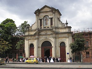
Administrative Department of Security
Law enforcement agency
Distance: Approx. 3586 meters
Latitude and longitude: 4.615,-74.0873
The Administrative Department of Security (Spanish: Departamento Administrativo de Seguridad, DAS) was the security service agency of Colombia, which was also responsible for border and immigration services. It was dissolved on 31 October 2011 as part of a wider Executive Reform, and was replaced by the Dirección Nacional de Inteligencia (DNI).
Antonio Nariño, Bogotá
Locality of Bogotá in Bogotá D.C., Colombia
Distance: Approx. 2065 meters
Latitude and longitude: 4.58416667,-74.11305556
Antonio Nariño is the 15th locality of Bogotá, capital of Colombia. It is located in the central part of the city. This district is mostly inhabited by middle class residents.

Los Mártires
Locality of Bogotá in Bogotá D.C., Colombia
Distance: Approx. 3005 meters
Latitude and longitude: 4.60444444,-74.09
Los Mártires (Spanish for "The Martyrs") is the 14th locality of Bogotá, capital of Colombia. It is located near the city's downtown to its west. This district is mostly inhabited by lower middle and working class residents.

General Santander National Police Academy
Police academy in Colombia
Distance: Approx. 1990 meters
Latitude and longitude: 4.59027778,-74.13027778
General Santander National Police Academy (or Escuela General Santander de la Policia Nacional in Spanish) is the main educational center for the Colombian National Police. The academy functions as a university for the formation of its force.

Estadio Metropolitano de Techo
Distance: Approx. 3140 meters
Latitude and longitude: 4.623545,-74.135611
Estadio Metropolitano de Techo is a multi-use stadium in Bogotá, Colombia. It is currently used mostly for football matches and is the home stadium of La Equidad, Fortaleza C.E.I.F., Tigres F.C., and Bogotá F.C. The stadium holds 10,000 people.
Tunjuelito
Locality of Bogotá in Bogotá D.C., Colombia
Distance: Approx. 2783 meters
Latitude and longitude: 4.58222222,-74.13194444
Tunjuelito is the 6th locality of the Capital District of the Colombian capital, Bogotá. Tunjuelito is located in the south of Bogotá, bordering to the north with the localities of Bosa, Kennedy and Puente Aranda, to the east with the localities of Rafael Uribe Uribe and Usme, to the south with Usme and to the west with Ciudad Bolívar. This district is mostly inhabited by working and lower class residents.

Puente Aranda
Locality of Bogotá in Bogotá D.C., Colombia
Distance: Approx. 1614 meters
Latitude and longitude: 4.6125,-74.10666667
Puente Aranda is the 16th location of the Capital District of the Colombian capital city, Bogotá. It is located in the center part of Bogotá. This district is mostly inhabited by lower middle and working class residents.

Rafael Uribe Uribe, Bogotá
Locality of Bogotá in Bogotá D.C., Colombia
Distance: Approx. 2514 meters
Latitude and longitude: 4.57972222,-74.1175
Rafael Uribe Uribe is the 18th locality of the Capital District in the Colombian capital Bogotá. This district is mostly inhabited by working and lower class residents. It was named after the Liberal General Rafael Uribe Uribe.

Centro Mayor
Shopping mall in Bogotá, Colombia
Distance: Approx. 1409 meters
Latitude and longitude: 4.59166667,-74.12388889
Centro Mayor is a shopping mall located in the south of Bogotá, Colombia. It was inaugurated on March 26, 2010. The mall has 248,000 m2 (2,667,000 sq ft) of built area, being the biggest mall in Colombia and the second one in Latin America, behind the Centro Comercial Aricanduva, in São Paulo, Brazil.
Quiroga, Bogotá
Barrio in Distrito Capital, Colombia
Distance: Approx. 2470 meters
Latitude and longitude: 4.5812,-74.1101
Quiroga is a neighbourhood (barrio) of Bogotá, Colombia.

Estadio Metropolitano Ciudad de Itagüí
Distance: Approx. 3096 meters
Latitude and longitude: 4.6233,-74.1353
Estadio Metropolitano Ciudad de Itagüí is a multi-use stadium in Itagüí, Colombia. It is currently used mostly for football matches by Leones F.C., currently playing in Categoría Primera B. The stadium has a capacity of 12,000 spectators.
2019 Bogotá car bombing
Attack on the Colombian General Santander Police Academy
Distance: Approx. 1926 meters
Latitude and longitude: 4.59083333,-74.13
On 17 January 2019, a vehicle was driven into the General Santander National Police Academy in Bogotá, Colombia. The truck forced its way into the facility, hit a wall and detonated, killing 22 people (including the perpetrator) and injuring 68 others. Suicide attacks are unusual in Colombia.
Weather in this IP's area
scattered clouds
12 Celsius
12 Celsius
12 Celsius
12 Celsius
1020 hPa
100 %
1020 hPa
758 hPa
10000 meters
1.54 m/s
10 degree
40 %
05:42:52
17:46:20