Country:
 Colombia
Region:
City:
Latitude and Longitude:
Time Zone:
Postal Code:
IP information under different IP Channel
ip-api
Country
Region
City
ASN
Time Zone
ISP
Blacklist
Proxy
Latitude
Longitude
Postal
Route
IPinfo
Country
Region
City
ASN
Time Zone
ISP
Blacklist
Proxy
Latitude
Longitude
Postal
Route
MaxMind
Country
Region
City
ASN
Time Zone
ISP
Blacklist
Proxy
Latitude
Longitude
Postal
Route
Luminati
Country
CORegion
dc
City
bogota
ASN
Time Zone
America/Bogota
ISP
Colombia
Latitude
Longitude
Postal
db-ip
Country
Region
City
ASN
Time Zone
ISP
Blacklist
Proxy
Latitude
Longitude
Postal
Route
ipdata
Country
Region
City
ASN
Time Zone
ISP
Blacklist
Proxy
Latitude
Longitude
Postal
Route
Popular places and events near this IP address
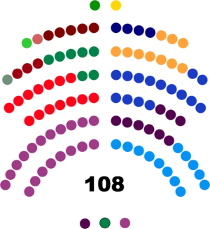
Senate of Colombia
Upper House of the Colombian Congress
Distance: Approx. 2733 meters
Latitude and longitude: 4.5975,-74.07638889
The Senate of the Republic of Colombia (Spanish: Senado de la República de Colombia) is the upper house of the Congress of Colombia, with the lower house being the Chamber of Representatives. The Senate has 108 members elected for concurrent (non-rotating) four-year terms.

Chamber of Representatives of Colombia
Lower house of the Congress of Colombia
Distance: Approx. 2732 meters
Latitude and longitude: 4.59833333,-74.07666667
The Chamber of Representatives (Spanish: Cámara de Representantes) is the lower house of the Congress of Colombia. It has 172 members elected to four-year terms.
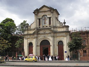
Antonio Nariño, Bogotá
Locality of Bogotá in Bogotá D.C., Colombia
Distance: Approx. 1611 meters
Latitude and longitude: 4.58416667,-74.11305556
Antonio Nariño is the 15th locality of Bogotá, capital of Colombia. It is located in the central part of the city. This district is mostly inhabited by middle class residents.

Los Mártires
Locality of Bogotá in Bogotá D.C., Colombia
Distance: Approx. 1908 meters
Latitude and longitude: 4.60444444,-74.09
Los Mártires (Spanish for "The Martyrs") is the 14th locality of Bogotá, capital of Colombia. It is located near the city's downtown to its west. This district is mostly inhabited by lower middle and working class residents.
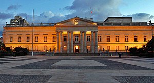
Casa de Nariño
Official residence and workplace of the President of Colombia
Distance: Approx. 2559 meters
Latitude and longitude: 4.59555556,-74.0775
The Casa de Nariño (Spanish pronunciation: ['ka sa ðe 'na ri]), literally the House of Nariño, is the official residence and principal workplace of the President of Colombia. It houses the main office of the executive branch and is located in the capital city of Bogotá, Colombia. It was dedicated in 1908 after being constructed on the site of the house where Antonio Nariño was born.

Puente Aranda
Locality of Bogotá in Bogotá D.C., Colombia
Distance: Approx. 2558 meters
Latitude and longitude: 4.6125,-74.10666667
Puente Aranda is the 16th location of the Capital District of the Colombian capital city, Bogotá. It is located in the center part of Bogotá. This district is mostly inhabited by lower middle and working class residents.

Rafael Uribe Uribe, Bogotá
Locality of Bogotá in Bogotá D.C., Colombia
Distance: Approx. 2283 meters
Latitude and longitude: 4.57972222,-74.1175
Rafael Uribe Uribe is the 18th locality of the Capital District in the Colombian capital Bogotá. This district is mostly inhabited by working and lower class residents. It was named after the Liberal General Rafael Uribe Uribe.

Centro Mayor
Shopping mall in Bogotá, Colombia
Distance: Approx. 2654 meters
Latitude and longitude: 4.59166667,-74.12388889
Centro Mayor is a shopping mall located in the south of Bogotá, Colombia. It was inaugurated on March 26, 2010. The mall has 248,000 m2 (2,667,000 sq ft) of built area, being the biggest mall in Colombia and the second one in Latin America, behind the Centro Comercial Aricanduva, in São Paulo, Brazil.

El Cartucho
Barrio in Distrital Capital Cundinamarca, Colombia
Distance: Approx. 2213 meters
Latitude and longitude: 4.59761,-74.08137639
El Cartucho or Calle del Cartucho was a street in the neighborhood of Santa Inés in Bogota which was destroyed and replaced by a park. At its time, it was one of the poorest and most dangerous areas in Colombia, known for rampant drug trafficking and inhabited by the poverty stricken. El Cartucho was widely considered to be a symbol of urban degradation.
Quiroga, Bogotá
Barrio in Distrito Capital, Colombia
Distance: Approx. 1526 meters
Latitude and longitude: 4.5812,-74.1101
Quiroga is a neighbourhood (barrio) of Bogotá, Colombia.

Bogotá La Sabana railway station
Distance: Approx. 2634 meters
Latitude and longitude: 4.60726,-74.08324
The Bogotá La Sabana railway station (in Spanish: Estación de la Sabana) is a neoclassical building in Bogotá (Colombia), home to the central station of the Bogotá Savannah Railway and the National Railways of Colombia (Ferrocarriles Nacionales de Colombia, FNC). Inaugurated on 20 July 1917, this construction replaced the old station built at the end of the 1880s. It is located on the locality of Los Mártires, near the downtown of the city.
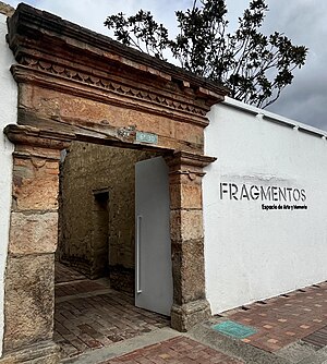
Fragmentos
Monument and Art Gallery by Doris Salcedo
Distance: Approx. 2330 meters
Latitude and longitude: 4.5925,-74.0791
Fragmentos, Espacio de Arte y Memoria (2018) (Spanish for "Fragments, a Space for Art and Memory") is a site-specific art installation, art gallery, and memorial created by Colombian artist Doris Salcedo and architect Carlos Granada. The main focus of the installation is the 1,288 floor tiles that were made by melting down the firearms that were turned in by the now-defunct FARC guerrilla group after the signing of the Colombian peace agreement in 2016. The art installation has been described by Salcedo as a "countermonument" and a space to reflect on the Colombian conflict.
Weather in this IP's area
scattered clouds
11 Celsius
11 Celsius
11 Celsius
11 Celsius
1019 hPa
100 %
1019 hPa
754 hPa
10000 meters
1.03 m/s
40 %
05:42:47
17:46:17