Country:
 Colombia
Region:
City:
Latitude and Longitude:
Time Zone:
Postal Code:
IP information under different IP Channel
ip-api
Country
Region
City
ASN
Time Zone
ISP
Blacklist
Proxy
Latitude
Longitude
Postal
Route
IPinfo
Country
Region
City
ASN
Time Zone
ISP
Blacklist
Proxy
Latitude
Longitude
Postal
Route
MaxMind
Country
Region
City
ASN
Time Zone
ISP
Blacklist
Proxy
Latitude
Longitude
Postal
Route
Luminati
Country
CORegion
dc
City
bogota
ASN
Time Zone
America/Bogota
ISP
Colombia
Latitude
Longitude
Postal
db-ip
Country
Region
City
ASN
Time Zone
ISP
Blacklist
Proxy
Latitude
Longitude
Postal
Route
ipdata
Country
Region
City
ASN
Time Zone
ISP
Blacklist
Proxy
Latitude
Longitude
Postal
Route
Popular places and events near this IP address

Estadio El Campín
Football stadium
Distance: Approx. 957 meters
Latitude and longitude: 4.64611111,-74.0775
The Estadio Nemesio Camacho El Campín, commonly known as El Campín, is the main stadium of Bogotá, Colombia. It was inaugurated on 10 August 1938 and has a capacity of 39,512 spectators. It is the home ground of the Categoría Primera A teams Millonarios and Santa Fe.

National University of Colombia
Public research university in Colombia
Distance: Approx. 1168 meters
Latitude and longitude: 4.63555556,-74.08277778
The National University of Colombia (Spanish: Universidad Nacional de Colombia) is a national public research university in Colombia, with general campuses in Bogotá, Medellín, Manizales and Palmira, and satellite campuses in Leticia, San Andrés, Arauca, Tumaco, and La Paz, Cesar. Established in 1867 by an act of the Congress of Colombia, it is one of the largest universities in the country, with more than 53,000 students. The university grants academic degrees and offers 450 academic programmes, including 95 undergraduate degrees, 83 academic specializations, 40 medical specialties, 167 master's degrees, and 65 doctorates.

Universidad Nacional (TransMilenio)
Distance: Approx. 755 meters
Latitude and longitude: 4.6369,-74.0793
The simple-station Universidad Nacional de Colombia is part of the TransMilenio mass-transit system of Bogotá, Colombia, opened in the year 2000.

Campín (TransMilenio)
Transit station in Bogotá, Colombia
Distance: Approx. 968 meters
Latitude and longitude: 4.6453,-74.0787
The simple-station Campín is part of the TransMilenio mass-transit system of Bogotá, Colombia, opened in the year 2005.

Avenida Caracas
Road in Bogotá, Colombia
Distance: Approx. 1202 meters
Latitude and longitude: 4.64638889,-74.065
Avenida Caracas is an arterial road in Bogotá, Colombia that runs through the city from north to south.
Pilot University of Colombia
Private coeducational research university in Colombia
Distance: Approx. 1118 meters
Latitude and longitude: 4.63222222,-74.06527778
The Universidad Piloto de Colombia, is a private, national, coeducational research university, located primarily in Bogotá, Colombia. It offers academic programs in undergraduate, specializations, masters and doctorates. Its president is Patricia Piedrahíta Castillo.
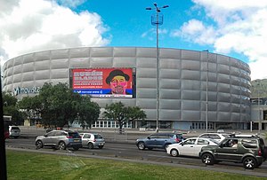
Movistar Arena (Bogotá)
Indoor sporting arena in Bogotá, Colombia
Distance: Approx. 1244 meters
Latitude and longitude: 4.64916667,-74.07722222
Movistar Arena, previously known as Coliseo Cubierto El Campín, is an indoor sporting arena located in Bogotá, Colombia. It was built in 1973 and renovated in 2018. The arena holds 90 shows per year.

Saint Thomas Aquinas University
Distance: Approx. 932 meters
Latitude and longitude: 4.63805556,-74.06444444
Saint Thomas University (Spanish: Universidad Santo Tomás) is a Roman Catholic university located in Bogotá, Colombia. It is the oldest Colombian university, founded in 1580 by the Dominican Order. It has campuses in Bucaramanga, Tunja, Medellín, and Villavicencio, and offers distance education.

Catholic University of Colombia
Distance: Approx. 837 meters
Latitude and longitude: 4.63416667,-74.06694444
The Catholic University of Colombia is a private institution of higher education. It was founded in Bogotá, Colombia in 1970, notable in its early loyalty to Catholic church doctrine. The institution had more than ten thousand students in September 2019, of which the majority were undergraduates.
Cadena Melodía
Colombian radio network
Distance: Approx. 946 meters
Latitude and longitude: 4.632505,-74.067185
Cadena Melodía is a Colombian radio network, founded in 1971 by Liberal politician Efraín Páez Espitia, who owned Radio Melodía of Bogotá since 1959.
Radio Líder
Radio station
Distance: Approx. 946 meters
Latitude and longitude: 4.632505,-74.067185
Radio Líder was the flagship station of the AM network of Cadena Melodía, a Colombian radio network. It started in 1947 as Radio Industrial. It would later be renamed to Radio Capital, until 1959 when Liberal party politician Efraín Páez Espitia bought the station and changed its name to Radio Melodía.
HJCU
Radio station
Distance: Approx. 946 meters
Latitude and longitude: 4.632505,-74.067185
HJCU (AM 730 kHz)is a radio station in Bogotá, Colombia, part of the Cadena Melodía network. Since its inception, it has been focused on the easy listening genre, with some news on mornings and afternoons on weekdays. The radio station ceased to broadcast on FM because the owners of the frequency decided to lease it to Grupo Valorem, a Colombian group that owns Caracol Televisión, which created Bluradio.
Weather in this IP's area
scattered clouds
11 Celsius
11 Celsius
11 Celsius
11 Celsius
1019 hPa
100 %
1019 hPa
754 hPa
10000 meters
1.03 m/s
40 %
05:42:42
17:46:09