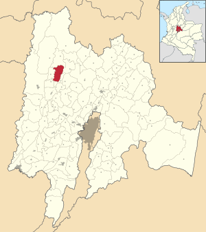
Country:
Region:
City:
Latitude and Longitude:
Time Zone:
Postal Code:
IP information under different IP Channel
ip-api
Country
Region
City
ASN
Time Zone
ISP
Blacklist
Proxy
Latitude
Longitude
Postal
Route
Luminati
Country
Region
ant
City
medellin
ASN
Time Zone
America/Bogota
ISP
TV AZTECA SUCURSAL COLOMBIA
Latitude
Longitude
Postal
IPinfo
Country
Region
City
ASN
Time Zone
ISP
Blacklist
Proxy
Latitude
Longitude
Postal
Route
db-ip
Country
Region
City
ASN
Time Zone
ISP
Blacklist
Proxy
Latitude
Longitude
Postal
Route
ipdata
Country
Region
City
ASN
Time Zone
ISP
Blacklist
Proxy
Latitude
Longitude
Postal
Route
Popular places and events near this IP address

Útica
Municipality and town in Cundinamarca, Colombia
Distance: Approx. 509 meters
Latitude and longitude: 5.18333333,-74.48333333
Utica is a town and municipality in the Cundinamarca Department, Colombia located some 127 kilometers from Bogotá. The village lies at an altitude of 506 meters above sea level and has an average daily temperature of 26 °C. Utica grew from a small fishing community, with the Rio Negro and the Quebradanegra running through it. The village is prone to flooding, caused by heavy rains further up the Andes causing the rivers to burst their banks.

La Peña, Cundinamarca
Municipality and town in Cundinamarca, Colombia
Distance: Approx. 9778 meters
Latitude and longitude: 5.19916667,-74.39361111
La Peña is a municipality and town of Colombia in the department of Cundinamarca. La Peña is located in the west of Cundinamarca, in Gualivá Province, 93 kilometres (58 mi) from Bogotá.

Quebradanegra
Municipality and town in Cundinamarca, Colombia
Distance: Approx. 7739 meters
Latitude and longitude: 5.11777778,-74.47916667
Quebradanegra (Spanish pronunciation: [keβɾaðaˈneɣɾa]) is a municipality and town of Colombia in the department of Cundinamarca.
Weather in this IP's area
overcast clouds
22 Celsius
23 Celsius
22 Celsius
22 Celsius
1011 hPa
99 %
1011 hPa
944 hPa
10000 meters
0.8 m/s
0.77 m/s
85 degree
100 %
05:47:09
17:39:35