Country:
Region:
City:
Latitude and Longitude:
Time Zone:
Postal Code:
IP information under different IP Channel
ip-api
Country
Region
City
ASN
Time Zone
ISP
Blacklist
Proxy
Latitude
Longitude
Postal
Route
Luminati
Country
ASN
Time Zone
America/Bogota
ISP
HUGHES DE COLOMBIA S.A.S.
Latitude
Longitude
Postal
IPinfo
Country
Region
City
ASN
Time Zone
ISP
Blacklist
Proxy
Latitude
Longitude
Postal
Route
db-ip
Country
Region
City
ASN
Time Zone
ISP
Blacklist
Proxy
Latitude
Longitude
Postal
Route
ipdata
Country
Region
City
ASN
Time Zone
ISP
Blacklist
Proxy
Latitude
Longitude
Postal
Route
Popular places and events near this IP address

Viceroyalty of New Granada
Viceroyalty of the Spanish Empire (1717–1822)
Distance: Approx. 724 meters
Latitude and longitude: 4.65,-74.05
The Viceroyalty of the New Kingdom of Granada (Spanish: Virreinato del Nuevo Reino de Granada [birejˈnato ðe ˈnweβa ɣɾaˈnaða]), also called Viceroyalty of New Granada or Viceroyalty of Santa Fe, was the name given on 27 May 1717 to the jurisdiction of the Spanish Empire in northern South America, corresponding to modern Colombia, Ecuador, Panama and Venezuela. Created in 1717 by King Felipe V, as part of a new territorial control policy, it was suspended in 1723 for financial problems and was restored in 1739 until the independence movement suspended it again in 1810. The territory corresponding to Panama was incorporated later in 1739, and the provinces of Venezuela were separated from the Viceroyalty and assigned to the Captaincy General of Venezuela in 1777.

Gimnasio Moderno
School in Bogotá, Colombia
Distance: Approx. 559 meters
Latitude and longitude: 4.65944444,-74.05583333
The Gimnasio Moderno is a private mixed gender elite-traditional and liberal, primary and secondary school located in Bogotá, Colombia. It was founded in 1914 by Colombians following the leading initiative of Agustín Nieto Caballero.

United States of Colombia
1863–1886 state in South America
Distance: Approx. 724 meters
Latitude and longitude: 4.65,-74.05
United States of Colombia (Spanish: Estados Unidos de Colombia) was the name adopted in 1863 by the Constitución de Rionegro for the Granadine Confederation, after years of civil war. Colombia became a federal state itself composed of nine "sovereign states.” It comprised the present-day nations of Colombia and Panama and parts of northwestern Brazil. After several more years of intermittent civil wars, it was replaced by the more centralist Republic of Colombia in 1886, predecessor to modern Colombia.
Rosales, Bogotá
Barrio in Distrito Capital, Colombia
Distance: Approx. 597 meters
Latitude and longitude: 4.66013889,-74.04836111
Rosales is a barrio in the Chapinero locality of Bogotá.

2003 El Nogal Club bombing
Terrorist attack in Colombia in 2003
Distance: Approx. 462 meters
Latitude and longitude: 4.66015,-74.05074
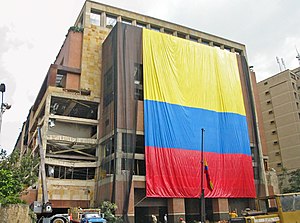
The 2003 El Nogal Club bombing was a terrorist attack that occurred in Bogotá, Colombia. On 7 February 2003, a car containing 200 kg of explosives that was parked in a garage on the third floor of the multi-story El Nogal club, an elite, high-class social and business club, exploded, killing 36 people and wounding more than 200. There were approximately 600 people in the building at the time of the explosion.

Colombia Stock Exchange
Distance: Approx. 489 meters
Latitude and longitude: 4.65414444,-74.05589722
The Colombia Securities Exchange (Spanish: Bolsa de Valores de Colombia, bvc) is a stock exchange which was created as a result of merging three independent stock exchanges: Bogotá (Bolsa de Bogotá, 1928), Medellín (Bolsa de Medellín, 1961) and Occidente (Bolsa de Occidente, Cali, 1983). It has offices in Bogotá, Medellín and Cali. Furthermore, with the bvc Training Centers the company is located in 19 Colombian cities through agreements with universities and chambers of commerce.

Republic of New Granada
1831–1858 state in South America
Distance: Approx. 724 meters
Latitude and longitude: 4.65,-74.05
The Republic of New Granada was a centralist unitary republic consisting primarily of present-day Colombia and Panama with smaller portions of today's Costa Rica, Ecuador, Venezuela, Peru and Brazil that existed from 1831 to 1858. The state was created after the dissolution of Great Colombia in 1830 through the secession of Ecuador and Venezuela. In 1858 the state was renamed into the Granadine Confederation.

Granadine Confederation
1858–1863 federal state in Central and South America
Distance: Approx. 724 meters
Latitude and longitude: 4.65,-74.05
The Granadine Confederation (Spanish: Confederación Granadina) was a short-lived federal republic established in 1858 as a result of a constitutional change replacing the Republic of New Granada. It consisted of the present-day nations of Colombia and Panama and parts of northwestern Brazil. In turn, the Granadine Confederation was replaced by the United States of Colombia after another constitutional change in 1863.

Gran Colombia
Republic in South and Central America from 1819 to 1831
Distance: Approx. 724 meters
Latitude and longitude: 4.65,-74.05
Gran Colombia (Spanish pronunciation: [ˈɡɾaŋ koˈlombja] , "Great Colombia"), or Greater Colombia, officially the Republic of Colombia (Spanish: República de Colombia), was a state that encompassed much of northern South America and part of southern North America (aka southern Central America) from 1819 to 1831. It included present-day Colombia, mainland Ecuador (i.e. excluding the Galápagos Islands), Panama, and Venezuela, along with parts of northern Peru, northwestern Brazil, and claimed the Essequibo region.

Cundinamarca State
1857–1886 state of Colombia
Distance: Approx. 724 meters
Latitude and longitude: 4.65,-74.05
Cundinamarca State was one of the states of Colombia. It was created on 15 June 1857 as Estado Federal de Cundinamarca (Federal State of Cundinamarca), in 1858 was recognized as Estado de la Federación, and in the constitution of 1863 renamed as Estado Soberano (Sovereign State of Cundinamarca) of the United States of Colombia. It was abolished in 1886.
List of ambassadors of Paraguay to Colombia
Distance: Approx. 712 meters
Latitude and longitude: 4.656429,-74.058417
The Paraguayan ambassador in Bogotá is the official representative of the Government in Asunción to the Government of Colombia.

Embassy of Indonesia, Bogotá
Diplomatic mission
Distance: Approx. 725 meters
Latitude and longitude: 4.65349,-74.057949
The Embassy of the Republic of Indonesia in Bogotá (Indonesian: Kedutaan Besar Republik Indonesia di Bogota; Spanish: Embajada de la República de Indonesia en Bogotá) is the diplomatic mission of the Republic of Indonesia to the Republic of Colombia and concurrently accredited to Antigua and Barbuda, Barbados and the Federation of Saint Christopher and Nevis. Diplomatic relations between Indonesia and Colombia were established on 15 September 1980. Initially, the Indonesian embassy in Brasilia, Brazil was accredited to Colombia.
Weather in this IP's area
few clouds
8 Celsius
6 Celsius
8 Celsius
8 Celsius
1018 hPa
100 %
1018 hPa
738 hPa
9000 meters
2.06 m/s
340 degree
20 %
05:41:39
17:37:58
