Country:
 Great Britain
Region:
City:
Latitude and Longitude:
Time Zone:
Postal Code:
IP information under different IP Channel
ip-api
Country
Region
City
ASN
Time Zone
ISP
Blacklist
Proxy
Latitude
Longitude
Postal
Route
IPinfo
Country
Region
City
ASN
Time Zone
ISP
Blacklist
Proxy
Latitude
Longitude
Postal
Route
MaxMind
Country
Region
City
ASN
Time Zone
ISP
Blacklist
Proxy
Latitude
Longitude
Postal
Route
Luminati
Country
GBRegion
eng
City
leeds
ASN
Time Zone
Europe/London
ISP
Host Europe GmbH
Latitude
Longitude
Postal
db-ip
Country
Region
City
ASN
Time Zone
ISP
Blacklist
Proxy
Latitude
Longitude
Postal
Route
ipdata
Country
Region
City
ASN
Time Zone
ISP
Blacklist
Proxy
Latitude
Longitude
Postal
Route
Popular places and events near this IP address

Leeds and Liverpool Canal
Canal in the north of England
Distance: Approx. 344 meters
Latitude and longitude: 53.79277778,-1.54805556
The Leeds and Liverpool Canal is a canal in Northern England, linking the cities of Leeds and Liverpool. Over a distance of 127 miles (204 km), crossing the Pennines, and including 91 locks on the main line. The Leeds and Liverpool Canal has several small branches, and in the early 21st century a new link was constructed into the Liverpool docks system.

Leeds Central railway station
Disused railway station in West Yorkshire, England
Distance: Approx. 208 meters
Latitude and longitude: 53.795785,-1.554704
Leeds Central railway station was a terminus railway station in Leeds, West Yorkshire, England. It was opened in 1854 as a joint station between the London and North Western Railway, the Lancashire and Yorkshire Railway, the Great Northern Railway and the North Eastern Railway. It replaced the cramped LNW terminus at Wellington Street, which had opened in 1848 with the line to Dewsbury.
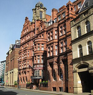
The Met Hotel
Grade II listed hotel in Leeds, West Yorkshire, England
Distance: Approx. 313 meters
Latitude and longitude: 53.79711111,-1.55063889
The Met Hotel is a Grade II listed building situated on King Street in Leeds, West Yorkshire, England. Designed by Leeds-based architects Harry Sutton Chorley and J.W. Connon, the hotel opened in 1899 as the Hotel Metropole. The Principal Hayley Group renovated the hotel in 2005, at a cost of £6 million, and changed the name to the trendier sounding 'The Met'.

Queens Hotel, Leeds
Hotel in Leeds, West Yorkshire, England
Distance: Approx. 340 meters
Latitude and longitude: 53.7959,-1.5478
The Queens Hotel is a large hotel located on City Square in Leeds, West Yorkshire, England. Built in 1937, it is an elegant Art Deco Grade II listed building and was frequented by the likes of Princess Grace of Monaco, Cary Grant and Nelson Mandela throughout its history.

Tower Works
Distance: Approx. 172 meters
Latitude and longitude: 53.793,-1.553
Tower Works is a former factory notable for its three listed towers. It is located on Globe Road in Holbeck, Leeds, West Yorkshire, next to the Leeds and Liverpool Canal. The Italianate towers of the factory are a distinctive landmark on the Leeds skyline.

Granary Wharf
Area of Leeds city centre, England
Distance: Approx. 288 meters
Latitude and longitude: 53.79416667,-1.54805556
Granary Wharf is a mixed-use development that stands next to the brick tunnels beside the Leeds and Liverpool Canal, and the River Aire in Leeds, West Yorkshire, England. Leeds City railway station sits above the brick tunnels on Dark Neville Street. The tunnel complex is known locally as the Dark Arches.

4th White Cloth Hall
Distance: Approx. 313 meters
Latitude and longitude: 53.79711111,-1.55063889
The 4th White Cloth Hall was a market for the sale of undyed cloth on King Street in Leeds city centre in England. A blue plaque for the building can be found on the nearby Quebec Street. The 4th White Cloth hall was built in 1868 by the North Eastern Railway company to replace the 3rd White Cloth Hall that they had had to partly demolish in 1865 to build the impressive North Eastern Viaduct to access the New Station.
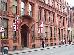
Quebecs Hotel, Leeds
Distance: Approx. 324 meters
Latitude and longitude: 53.796711,-1.549205
Quebecs is a Grade II listed 4-star hotel with 44 rooms located on Quebec Street in Leeds, West Yorkshire, England. Built in 1891, the building has two-storey-high stained glass windows which display the coats of arms of the principal towns of Yorkshire. Previously the building was used as the headquarters of the Leeds & County Liberal Club.
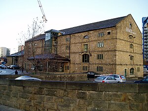
Granary Buildings, Leeds
Historic site in West Yorkshire, England
Distance: Approx. 314 meters
Latitude and longitude: 53.79277778,-1.54861111
Granary Buildings is a heritage listed building in Leeds, West Yorkshire, England.
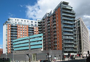
West Point (building)
Tower block in Leeds, United Kingdom
Distance: Approx. 186 meters
Latitude and longitude: 53.79598,-1.553707
West Point, formerly known as Royal Mail House, is a 65 metres (213 ft) tall 17-floor residential tower block located at number 29 of Wellington Street in Leeds, West Yorkshire, England. It was conceived as a landmark building in the skyline and a key gateway building to the city, and the start of redevelopment of the west part of the city.

Majestic, Leeds
Building in Leeds, West Yorkshire, England
Distance: Approx. 312 meters
Latitude and longitude: 53.79638889,-1.54888889
The Majestic is a Grade II listed building on City Square, Leeds, occupying the corner of Quebec Street and Wellington Street. Constructed as a cinema in the early 1920s during a boom in the building of picture palaces, it was closed in 1969, after which the Majestic was used as a bingo hall and later as a nightclub. The building was listed at Grade II in 1993 as the Top Rank Bingo Hall and, in 2014, was badly damaged in a fire, resulting in the loss of all original interior and roof.
Leeds (Whitehall Road) power station
Former power station in England
Distance: Approx. 92 meters
Latitude and longitude: 53.79527778,-1.55194444
Leeds power station, also known as Whitehall Road power station, supplied electricity to the city of Leeds and the surrounding area from 1893 to 1965. It was initially built, owned and operated by the Yorkshire House-to-House Electricity Company Limited. Leeds Corporation took over the electricity undertaking in 1898 and generated and distributed electricity until the nationalisation of the British electricity supply industry in 1948.
Weather in this IP's area
broken clouds
13 Celsius
12 Celsius
12 Celsius
14 Celsius
1032 hPa
90 %
1032 hPa
1027 hPa
10000 meters
2.06 m/s
50 degree
75 %
06:47:09
19:12:46