185.96.122.128 - IP Lookup: Free IP Address Lookup, Postal Code Lookup, IP Location Lookup, IP ASN, Public IP
Country:
Region:
City:
Location:
Time Zone:
Postal Code:
ISP:
ASN:
language:
User-Agent:
Proxy IP:
Blacklist:
IP information under different IP Channel
ip-api
Country
Region
City
ASN
Time Zone
ISP
Blacklist
Proxy
Latitude
Longitude
Postal
Route
db-ip
Country
Region
City
ASN
Time Zone
ISP
Blacklist
Proxy
Latitude
Longitude
Postal
Route
IPinfo
Country
Region
City
ASN
Time Zone
ISP
Blacklist
Proxy
Latitude
Longitude
Postal
Route
IP2Location
185.96.122.128Country
Region
malopolskie
City
ludzmierz
Time Zone
Europe/Warsaw
ISP
Language
User-Agent
Latitude
Longitude
Postal
ipdata
Country
Region
City
ASN
Time Zone
ISP
Blacklist
Proxy
Latitude
Longitude
Postal
Route
Popular places and events near this IP address

Nowy Targ
Place in Lesser Poland Voivodeship, Poland
Distance: Approx. 2472 meters
Latitude and longitude: 49.46666667,20.01666667
Nowy Targ [ˈnɔvɨ ˈtark] (Officially: Royal Free city of Nowy Targ, Yiddish: Naymark, Goral dialect: Miasto) is a town in southern Poland, in the Lesser Poland Voivodeship. It is located in the Orava-Nowy Targ Basin at the foot of the Gorce Mountains, at the confluence of the Czarny Dunajec and the Biały Dunajec. It is the seat of the Nowy Targ County and the rural Gmina Nowy Targ, as well as the Tatra Euroregion.

Podhale
Region of meadows
Distance: Approx. 3655 meters
Latitude and longitude: 49.479259,20.029127
Podhale (Polish pronunciation: [pɔtˈxalɛ] ; lit. 'below the mountain pastures'), sometimes referred to as the Polish Highlands, is Poland's southernmost region. The Podhale is located in the foothills of the Tatra range of the Carpathian Mountains. It is the most famous region of the Goral Lands which are a network of historical regions inhabited by Gorals.

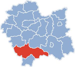
Nowy Targ County
County in Lesser Poland Voivodeship, Poland
Distance: Approx. 2472 meters
Latitude and longitude: 49.46666667,20.01666667
Nowy Targ County (Polish: powiat nowotarski) is a unit of territorial administration and local government (powiat) in Lesser Poland Voivodeship, southern Poland, on the Slovak border. It came into being on January 1, 1999, as a result of the Polish local government reforms passed in 1998. Its administrative seat and largest town is Nowy Targ, which lies 67 kilometres (42 mi) south of the regional capital Kraków.

Ludźmierz
Place in Lesser Poland Voivodeship, Poland
Distance: Approx. 410 meters
Latitude and longitude: 49.46944444,19.97888889
Ludźmierz [ˈlud͡ʑmjɛʂ] is a village in Poland in the Lesser Poland voivodeship, in the county of Nowy Targ. Ludźmierz is the oldest village in Podhale and is located about 85 kilometres south of Kraków. It lies approximately 3 kilometres (2 mi) west of Nowy Targ and 66 km (41 mi) south of the regional capital Kraków.

Gmina Nowy Targ
Gmina in Lesser Poland Voivodeship, Poland
Distance: Approx. 2472 meters
Latitude and longitude: 49.46666667,20.01666667
Gmina Nowy Targ is a rural gmina (administrative district) in Nowy Targ County, Lesser Poland Voivodeship, in southern Poland. Its seat is the town of Nowy Targ, although the town itself is not part of the territory of the gmina. The gmina covers an area of 208.65 square kilometres (80.6 sq mi), and as of 2006 its total population is 22,070.
Długopole
Village in Lesser Poland Voivodeship, Poland
Distance: Approx. 4015 meters
Latitude and longitude: 49.48333333,19.93333333
Długopole [dwuɡɔˈpɔlɛ] is a village in the administrative district of Gmina Nowy Targ, within Nowy Targ County, Lesser Poland Voivodeship, in southern Poland. It lies approximately 7 kilometres (4 mi) west of Nowy Targ and 65 km (40 mi) south of the regional capital Kraków.
Krauszów
Village in Lesser Poland Voivodeship, Poland
Distance: Approx. 2187 meters
Latitude and longitude: 49.48333333,19.96666667
Krauszów [ˈkrau̯ʂuf] is a village in the administrative district of Gmina Nowy Targ, within Nowy Targ County, Lesser Poland Voivodeship, in southern Poland. It lies approximately 5 kilometres (3 mi) north-west of Nowy Targ and 65 km (40 mi) south of the regional capital Kraków. The village has an approximate population of 700.

Rogoźnik, Lesser Poland Voivodeship
Village in Lesser Poland Voivodeship, Poland
Distance: Approx. 4154 meters
Latitude and longitude: 49.44388889,19.93694444
Rogoźnik [rɔˈɡɔʑnik] is a village in the administrative district of Gmina Nowy Targ, within Nowy Targ County, Lesser Poland Voivodeship, in southern Poland.
Trute
Village in Lesser Poland Voivodeship, Poland
Distance: Approx. 2944 meters
Latitude and longitude: 49.49138889,19.96833333
Trute [ˈtrutɛ] is a village in the administrative district of Gmina Nowy Targ, within Nowy Targ County, Lesser Poland Voivodeship, in southern Poland. Trute runs parallel to the river Lepietnica, the main street diverts in two directions creating a letter T shape. The village has a small forest that stretches along the boundaries.

Zaskale, Lesser Poland Voivodeship
Village in Lesser Poland Voivodeship, Poland
Distance: Approx. 1849 meters
Latitude and longitude: 49.45,19.98333333
Zaskale [zasˈkalɛ] is a village in the administrative district of Gmina Szaflary, within Nowy Targ County, Lesser Poland Voivodeship, in southern Poland. It lies approximately 5 kilometres (3 mi) north-west of Szaflary, 4 km (2 mi) south-west of Nowy Targ, and 68 km (42 mi) south of the regional capital Kraków.

Market Square, Nowy Targ
Square in Nowy Targ, Poland
Distance: Approx. 3904 meters
Latitude and longitude: 49.4825,20.0306
The Market Square (Polish: Rynek [ˈrɨnɛk]) in Nowy Targ is located in the center of the town. It was laid out for the first time in 1346, when the city was founded. There are 8 streets leading to the Market Square - two to each corner: Szaflarska St and Harcerska St to the south-eastern corner, John III Sobieski St and Tadeusz Kościuszko St to the north-east one, St.

Nowy Targ railway station
Railway station in Lesser Poland, Poland
Distance: Approx. 2202 meters
Latitude and longitude: 49.4735229,20.0110169
Nowy Targ railway station is a railway station in Nowy Targ (Lesser Poland), Poland. As of 2022, it is served by Koleje Śląskie (Silesian Voivodeship Railways), Polregio, and PKP Intercity (EIP, InterCity, and TLK services).
Weather in this IP's area
overcast clouds
2 Celsius
2 Celsius
2 Celsius
2 Celsius
1018 hPa
91 %
1018 hPa
924 hPa
10000 meters
0.45 m/s
0.4 m/s
171 degree
100 %
