Country:
 France
Region:
City:
Latitude and Longitude:
Time Zone:
Postal Code:
IP information under different IP Channel
ip-api
Country
Region
City
ASN
Time Zone
ISP
Blacklist
Proxy
Latitude
Longitude
Postal
Route
IPinfo
Country
Region
City
ASN
Time Zone
ISP
Blacklist
Proxy
Latitude
Longitude
Postal
Route
MaxMind
Country
Region
City
ASN
Time Zone
ISP
Blacklist
Proxy
Latitude
Longitude
Postal
Route
Luminati
Country
FRRegion
idf
City
paris
ASN
Time Zone
Europe/Paris
ISP
ADISTA SAS
Latitude
Longitude
Postal
db-ip
Country
Region
City
ASN
Time Zone
ISP
Blacklist
Proxy
Latitude
Longitude
Postal
Route
ipdata
Country
Region
City
ASN
Time Zone
ISP
Blacklist
Proxy
Latitude
Longitude
Postal
Route
Popular places and events near this IP address
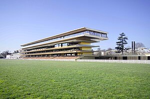
Longchamp Racecourse
Horse racing venue
Distance: Approx. 656 meters
Latitude and longitude: 48.85875,2.23277778
The Longchamp Racecourse (French: Hippodrome de Longchamp) is a 57 hectare horse-racing facility located on the Route des Tribunes at the Bois de Boulogne in the 16th arrondissement of Paris, France. It is used for flat racing and is noted for its variety of interlaced tracks and a famous hill that provides a real challenge to competing thoroughbreds. It has several racetracks varying from 1,000 to 4,000 metres in length, with 46 different starting posts.

Suresnes
Commune in Île-de-France, France
Distance: Approx. 1073 meters
Latitude and longitude: 48.87,2.22
Suresnes (French pronunciation: [syʁɛn] ) is a commune in the western inner suburbs of Paris, France. Located in Hauts-de-Seine, 9.3 km (5.8 mi) from the centre of Paris, it had a population of 49,482 as of 2020. Suresnes borders the Bois de Boulogne in the 16th arrondissement of Paris, across the Seine.

Suresnes American Cemetery and Memorial
Military cemetery in France
Distance: Approx. 1324 meters
Latitude and longitude: 48.87194444,2.21805556
The Suresnes American Cemetery (French: Cimetière américain de Suresnes) is a United States military cemetery in Suresnes, Hauts-de-Seine, France. It is the resting place of 1,541 American soldiers killed in World War I. A panoramic view of Paris can be seen from the site, which is located high on the slopes of Mont-Valérien.

Skema Business School
French business school
Distance: Approx. 120 meters
Latitude and longitude: 48.8618,2.225
SKEMA Business School ("School of Knowledge Economy and Management") is one of the leading French business schools devoted to higher education and research. It has the legal status of a non-profit association under the French "1901 law". It was founded in 2009 as a result of the merger between the Ecole Supérieure de Commerce (ESC), Lille and CERAM Business School, Sophia Antipolis.

Suresnes–Mont-Valérien station
Distance: Approx. 1233 meters
Latitude and longitude: 48.87166667,2.22111111
Suresnes–Mont-Valérien is a French railway station on the line from Paris-Saint-Lazare to Versailles-Rive-Droite, located in the territory of the commune of Suresnes, in the Hauts-de-Seine department, in the Île-de-France region. It notably serves the Foch Hospital, located opposite. The station opened in 1840, is today a station of the Société nationale des chemins de fer français (SNCF) served by the trains of line L of the Transilien (Paris-Saint-Lazare network) as well as those of line U (La Défense - La Verrière).

Mémorial de la France combattante
Monument in Suresnes, Hauts-de-Seine, France
Distance: Approx. 1426 meters
Latitude and longitude: 48.8716,2.2139
The Mémorial de la France combattante (Memorial to Fighting France) is the most important memorial to French fighters of World War II (1939–1945). It is situated below Fort Mont-Valérien in Suresnes, in the western suburbs of Paris. It commemorates members of the armed forces from France and the colonies, and members of the French Resistance.

Château Rothschild
French château
Distance: Approx. 1368 meters
Latitude and longitude: 48.85,2.2333
The Château Rothschild is a historic château in Boulogne-Billancourt near Paris, France.

Foch Hospital
Hospital in Île-de-France, France
Distance: Approx. 1160 meters
Latitude and longitude: 48.8711063,2.2220258
Foch Hospital (French: Hôpital Foch) is a teaching hospital in the Suresnes, France. It is part of the Établissement de santé privé d'intérêt collectif. It was established in 1929 with the help of Consuelo Vanderbilt and Winnaretta Singer.

Institut national supérieur de formation et de recherche pour l'éducation inclusive
Distance: Approx. 1130 meters
Latitude and longitude: 48.8689875,2.21525028
The Institut national supérieur de formation et de recherche pour l'éducation inclusive or INSEI (National Higher Institute for Training and Research for the Education of Young Disabled Persons and Special Education, formerly Institut national supérieur de formation et de recherche pour l'éducation des jeunes handicapés et les enseignements adaptés or INS-HEA) is a public college in Suresnes. It is part of the Université Paris Lumières. INSEI has its buildings next to the Fort Mont-Valérien, in Suresnes.

Musée d'histoire urbaine et sociale de Suresnes
Museum in Suresnes, France
Distance: Approx. 842 meters
Latitude and longitude: 48.86811111,2.22141667
The Musée d'histoire urbaine et sociale de Suresnes (English: Suresnes Urban and Social History Museum) is a museum of France installed since June 2013 in the old Suresnes - Longchamp train station building. Presenting the evolution of the city, it is particularly focused on the social urban planning of the 1920s and 1930s, of which the garden city and the Outdoor School are the most significant examples. The museum was initially budgeted at a cost of €8.3 million for a total area of approximately 1,300 square meters, including the creation of the 220 square meter extension intended for temporary exhibitions.

Suresnes-Longchamp station
Tram station in Suresnes, France
Distance: Approx. 862 meters
Latitude and longitude: 48.8682976,2.221418
Suresnes-Longchamp station is a former French railway station on the line from Puteaux to Issy-Plaine (Moulineaux line), which became a tram station on line 2 of the Île-de-France tramway (line T2). It is located in the territory of the commune of Suresnes, in the department of Hauts-de-Seine, in the Île-de-France region. It is also close to the Longchamp racecourse (located in Paris).

Val d'Or train station
Train station in France
Distance: Approx. 711 meters
Latitude and longitude: 48.8569,2.2167
The Val d'Or train station is a station on the railway line from Paris-Saint-Lazare to Versailles-Rive-Droite, located in the commune of Saint-Cloud, in the Hauts-de-Seine department of the Île-de-France region. In 1903, the Compagnie des chemins de fer de l'Ouest launched a halt to serve the Fouilleuse racecourse (now the Saint-Cloud racecourse). The halt took on its current name and configuration in 1911 when it became a station.
Weather in this IP's area
overcast clouds
14 Celsius
14 Celsius
13 Celsius
15 Celsius
1015 hPa
95 %
1015 hPa
1011 hPa
10000 meters
2.06 m/s
240 degree
100 %
08:16:17
18:55:46