185.93.55.149 - IP Lookup: Free IP Address Lookup, Postal Code Lookup, IP Location Lookup, IP ASN, Public IP
Country:
Region:
City:
Location:
Time Zone:
Postal Code:
IP information under different IP Channel
ip-api
Country
Region
City
ASN
Time Zone
ISP
Blacklist
Proxy
Latitude
Longitude
Postal
Route
Luminati
Country
Region
27
City
gaziantep
ASN
Time Zone
Europe/Istanbul
ISP
Veganet Teknolojileri ve Hizmetleri LTD STI
Latitude
Longitude
Postal
IPinfo
Country
Region
City
ASN
Time Zone
ISP
Blacklist
Proxy
Latitude
Longitude
Postal
Route
IP2Location
185.93.55.149Country
Region
mersin
City
erdemli
Time Zone
Europe/Istanbul
ISP
Language
User-Agent
Latitude
Longitude
Postal
db-ip
Country
Region
City
ASN
Time Zone
ISP
Blacklist
Proxy
Latitude
Longitude
Postal
Route
ipdata
Country
Region
City
ASN
Time Zone
ISP
Blacklist
Proxy
Latitude
Longitude
Postal
Route
Popular places and events near this IP address

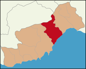
Erdemli
District and municipality in Mersin, Turkey
Distance: Approx. 250 meters
Latitude and longitude: 36.60555556,34.31111111
Erdemli is a municipality and district of Mersin Province, Turkey. Its area is 2,279 km2, and its population is 151,928 (2022). It is 35 km (22 mi) west of the city of Mersin.

Limonlu River
River in Turkey
Distance: Approx. 7589 meters
Latitude and longitude: 36.5575,34.2475
The Limonlu River (Ancient Greek: Λάμος Lamos; Latin: Lamus), also known as Gökler Deresi, is a river of ancient Cilicia, now in Mersin Province, Turkey. The river rises at Yüğlük Dağı in the Taurus mountains and flows through deep gorges to the southwest until it reaches the Mediterranean Sea at Limonlu (the ancient Antiochia Lamotis) in the district of Erdemli. About halfway along its course it is receives the Susama Deresi from the west as a tributary.

Limonlu, Mersin
Neighbourhood in Erdemli, Mersin, Turkey
Distance: Approx. 9084 meters
Latitude and longitude: 36.55,34.23333333
Limonlu (ancient: Antiochia Lamotidos; Byzantine: Lamousia; Arabic: Lāmis; Armenian: Lamos, popularly called Lamas) is a neighbourhood in the municipality and district of Erdemli, Mersin Province, Turkey. Its population is 2,939 (2022). Before the 2013 reorganisation, it was a town (belde).
Tömük
Settlement in Turkey
Distance: Approx. 9588 meters
Latitude and longitude: 36.66666667,34.38333333
Tömük is a neighbourhood in the municipality and district of Erdemli, Mersin Province, Turkey. Its population is 12,170 (2022). Before the 2013 reorganisation, Tömük was a town (belde).
Kocahasanlı
A settlement in Turkey
Distance: Approx. 4442 meters
Latitude and longitude: 36.58333333,34.26666667
Kocahasanlı is a neighbourhood in the municipality and district of Erdemli, Mersin Province, Turkey. Its population is 4,495 (2022). Before the 2013 reorganisation, it was a town (belde).

Arpaçbahşiş
A settlement in Turkey
Distance: Approx. 6237 meters
Latitude and longitude: 36.65,34.35
Arpaçbahşiş is a neighborhood within the municipality and district of Erdemli, Mersin Province, Turkey, with a population of 7,285 as of 2022. Prior to the administrative reorganization of 2013, it was classified as a town (belde). Currently, Arpaçbahşiş serves as a summer resort area, primarily attracting Turkish tourists.
Üçtepe, Erdemli
Neighbourhood in Erdemli, Mersin, Turkey
Distance: Approx. 7130 meters
Latitude and longitude: 36.58333333,34.23333333
Üçtepe (literally “three hills”) is a neighbourhood in the municipality and district of Erdemli, Mersin Province, Turkey. Its population is 1,387 (2022). It is situated to the north of Kocahasanlı, a town in Erdemli district.
Karakeşli
Neighbourhood in Erdemli, Mersin, Turkey
Distance: Approx. 5064 meters
Latitude and longitude: 36.65,34.31666667
Karakeşli is a neighbourhood in the municipality and district of Erdemli, Mersin Province, Turkey. Its population is 887 (2022). It is 6 kilometres (3.7 mi) north east of Erdemli and about 42 kilometres (26 mi) west of Mersin.
Çiriş, Erdemli
Neighbourhood in Erdemli, Mersin, Turkey
Distance: Approx. 8782 meters
Latitude and longitude: 36.63333333,34.21666667
Çiriş is a neighbourhood in the municipality and district of Erdemli, Mersin Province, Turkey. Its population is 1,000 (2022). It is situated to the south of the dense forestry of the Taurus Mountains.

Yanıkhan
Archaeological site in Turkey
Distance: Approx. 9984 meters
Latitude and longitude: 36.58333333,34.2
Yanıkhan is an archaeological site in Mersin Province, Turkey. It is about 5 kilometres (3.1 mi) northwest of Limonlu town. It is to the east of Limonlu-Esenpınar road and west of Limonlu River at about 36°35′N 34°12′E. Its distance to Erdemli is 18 kilometres (11 mi) and to Mersin is 54 kilometres (34 mi).
Kalanthia
Coastal town of ancient Cilicia
Distance: Approx. 405 meters
Latitude and longitude: 36.607498,34.305103
Kalanthia was a coastal town of ancient Cilicia, inhabited during the Roman and Byzantine eras. Its site is located near Erdemli in Asiatic Turkey.
Weather in this IP's area
overcast clouds
13 Celsius
12 Celsius
13 Celsius
13 Celsius
1020 hPa
65 %
1020 hPa
996 hPa
10000 meters
1.61 m/s
1.52 m/s
29 degree
100 %
