Country:
Region:
City:
Latitude and Longitude:
Time Zone:
Postal Code:
IP information under different IP Channel
ip-api
Country
Region
City
ASN
Time Zone
ISP
Blacklist
Proxy
Latitude
Longitude
Postal
Route
Luminati
Country
Region
vc
City
monfortedelcid
ASN
Time Zone
Europe/Madrid
ISP
Cable Aireworld S.A.U.
Latitude
Longitude
Postal
IPinfo
Country
Region
City
ASN
Time Zone
ISP
Blacklist
Proxy
Latitude
Longitude
Postal
Route
db-ip
Country
Region
City
ASN
Time Zone
ISP
Blacklist
Proxy
Latitude
Longitude
Postal
Route
ipdata
Country
Region
City
ASN
Time Zone
ISP
Blacklist
Proxy
Latitude
Longitude
Postal
Route
Popular places and events near this IP address
Sant Joan d'Alacant
Municipality in Spain
Distance: Approx. 1871 meters
Latitude and longitude: 38.40138889,-0.43666667
Sant Joan d'Alacant (Valencian: [ˈsaɲ dʒuˈan dalaˈkant]; Spanish: San Juan de Alicante [saŋ xwan de aliˈkante]), or simply Sant Joan (or San Juan), is a municipality belonging to Alicante metropolitan area, in the southeast of Valencian Community, Spain. It is the geographic center of the Old Garden of Alicante. Its limits are with the settled areas of Alicante (7 km), Mutxamel (1 km) and El Campello (3 km).
El Campello
Municipality in Valencian Community, Spain
Distance: Approx. 4575 meters
Latitude and longitude: 38.4275,-0.40111111
El Campello (Valencian: [el kamˈpeʎo]; Spanish: Campello [kamˈpeʎo]) is a town on the Costa Blanca of Spain, within the Valencian Community. It is a 20-minute tram ride from Alicante city. There is a busy marina and fish market.

Alicante Tram
Railway system in Alicante, Spain
Distance: Approx. 5462 meters
Latitude and longitude: 38.36527778,-0.44444444
The Alicante Tram, trademarked as Alicante Metropolitan TRAM (Valencian: TRAM Metropolità d'Alacant, Spanish: TRAM Metropolitano de Alicante), operates in the Spanish city of Alicante (Valencian Community) and its surrounding area. Like other narrow gauge railways in the Valencian Community, it is run by Ferrocarrils de la Generalitat Valenciana (FGV). It was inaugurated on 15 August 2003 replacing narrow-gauge diesel trains between Alicante and El Campello.

Archaeological Museum of Alicante
Archaeology museum in Alicante, Spain
Distance: Approx. 7082 meters
Latitude and longitude: 38.35375,-0.47638889
The Archaeological Museum of Alicante (Spanish: Museo Arqueológico Provincial de Alicante, Valencian: Museu Arqueològic Provincial d'Alacant, abbreviated as MARQ) is an archaeological museum in Alicante, Spain. The museum won the European Museum of the Year Award in 2004, a few years after significant expansion and reallocation to renovated buildings of the antique hospital of San Juan de Dios. The museum houses eight galleries that use multimedia to allow visitors to interact with the lives of past residents of the region.
San Vicente del Raspeig / Sant Vicent del Raspeig
Municipality in Valencian Community, Spain
Distance: Approx. 6798 meters
Latitude and longitude: 38.39638889,-0.52527778
San Vicente del Raspeig (Spanish) or Sant Vicent del Raspeig (Valencian), or simply San Vicente / Sant Vicent, is a municipality located in the comarca of Alacantí, in the province of Alicante, Spain, inside the conurbation of Alicante city (6 km away and connected by bus routes and tram). It has an area of 40.5 km² and according to the 2007 census, a total population of 55.434 inhabitants, with a large student population because it contains part of the University of Alicante (Universitat d'Alacant), a major educational institution. The town was founded in 1836 with the motto sequet però sanet ("dry but healthy"), but it was not considered a municipality until 1848.

Lucentum
Human settlement in Alicante, L'Alacantí, Alicante Province, Spain
Distance: Approx. 5632 meters
Latitude and longitude: 38.36444444,-0.43833333
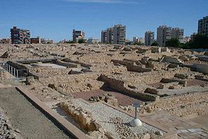
Lucentum (‹See Tfd›Greek: Λούκεντον, Loúkenton), called Lucentia by Pomponius Mela, is the Roman predecessor of the city of Alicante, Spain. Particularly, it refers to the archaeological site in which the remains of this ancient settlement lie, at a place known as El Tossal de Manises, in the neighborhood of Albufereta.
University of Alicante
Distance: Approx. 6359 meters
Latitude and longitude: 38.38463889,-0.51314722
The University of Alicante (Valencian: Universitat d'Alacant, IPA: [univeɾsiˈtad dalaˈkant]; Spanish: Universidad de Alicante, IPA: [uniβeɾsiˈðað ðe aliˈkante]; also known by the acronym UA) was established in 1979 on the basis of the Center for University Studies (CEU), which was founded in 1968. The university main campus is located in San Vicente del Raspeig/Sant Vicent del Raspeig, bordering the city of Alicante to the north. As of 2011/12 academic year, there are approximately 27,500 students studying there.

Dona Lluna
Distance: Approx. 6020 meters
Latitude and longitude: 38.394177,-0.51485
Dona Lluna: A Tribute to Womankind is a sculpture by Saülo Mercader, standing in the middle of a rotunda, in the heart of the City of Sant Vicent del Raspeig, the home of Alicante University, in Southeastern Spain. It was unveiled on March 11, 2007 by local dignitaries and a symphony orchestra from Madrid. The sculpture, representing the shape of a powerful and massive female body, weighs 2 tons and is 4 metres high.

Mutxamel
Municipality in Valencia, Spain
Distance: Approx. 452 meters
Latitude and longitude: 38.41361111,-0.44555556
Mutxamel (Valencian: [mutʃaˈmɛl]; Spanish: Muchamiel [mutʃaˈmjel]) is a municipality in the comarca of Alacantí, Alicante, Valencian Community, Spain.

El Barco, Alicante
Distance: Approx. 5944 meters
Latitude and longitude: 38.360711,-0.449646
El Barco (The Ship) is a residential apartment tower in Albufereta, Alicante, Spain. It is formally called Torre Vistamar de la Albufereta, meaning "Albufereta Sea View Tower". El Barco was one of a cluster of buildings erected in the former village of Albufereta for "Pied-Noirs", or residents from France and other European countries, in Francoist Spain.
Lycée Français d'Alicante
School
Distance: Approx. 3582 meters
Latitude and longitude: 38.40151,-0.41291
Lycée Français d'Alicante Pierre Deschamps (LFA; Spanish: Liceo Francés de Alicante) is a French international school in El Campello, Alicante Province, Spain. It serves maternelle/educación infantil (preschool) through lycée/bachillerato. As of 2016 the main campus, which is adjacent to Villa Marco, has about 1,300 students.
College of the Immaculate, Alicante
Jesuit, catholic school in Alicante, Spain
Distance: Approx. 6018 meters
Latitude and longitude: 38.36110278,-0.46430556
College of the Immaculate, Alicante, Spain, was founded by the Society of Jesus in 1954. It is coeducational and includes three-year-olds through primary, secondary (ESO), and baccalaureate.
Weather in this IP's area
broken clouds
18 Celsius
17 Celsius
17 Celsius
18 Celsius
1020 hPa
74 %
1020 hPa
1012 hPa
10000 meters
6.17 m/s
60 degree
75 %
07:43:49
17:49:19


