Country:
 Switzerland
Region:
City:
Latitude and Longitude:
Time Zone:
Postal Code:
IP information under different IP Channel
ip-api
Country
Region
City
ASN
Time Zone
ISP
Blacklist
Proxy
Latitude
Longitude
Postal
Route
IPinfo
Country
Region
City
ASN
Time Zone
ISP
Blacklist
Proxy
Latitude
Longitude
Postal
Route
MaxMind
Country
Region
City
ASN
Time Zone
ISP
Blacklist
Proxy
Latitude
Longitude
Postal
Route
Luminati
Country
CHASN
Time Zone
Europe/Zurich
ISP
Quickline AG
Latitude
Longitude
Postal
db-ip
Country
Region
City
ASN
Time Zone
ISP
Blacklist
Proxy
Latitude
Longitude
Postal
Route
ipdata
Country
Region
City
ASN
Time Zone
ISP
Blacklist
Proxy
Latitude
Longitude
Postal
Route
Popular places and events near this IP address

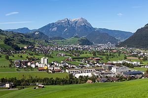
Stans
Municipality in Nidwalden, Switzerland
Distance: Approx. 1454 meters
Latitude and longitude: 46.95,8.35
Stans (German pronunciation: [ʃtans]) is the capital of the canton of Nidwalden (Nidwald) in Switzerland. The official language of Stans is German (spoken there in the variety of Swiss Standard German), but the main language is the local variant of Alemannic Swiss German.

Dallenwil
Municipality in Nidwalden, Switzerland
Distance: Approx. 2966 meters
Latitude and longitude: 46.93333333,8.38333333
Dallenwil is a municipality in the canton of Nidwalden in Switzerland.

Ennetmoos
Municipality in Nidwalden, Switzerland
Distance: Approx. 2606 meters
Latitude and longitude: 46.95,8.33333333
Ennetmoos is a municipality in the canton of Nidwalden in Switzerland.
Oberdorf, Nidwalden
Municipality in Nidwalden, Switzerland
Distance: Approx. 1544 meters
Latitude and longitude: 46.95,8.38333333
Oberdorf is a municipality in the canton of Nidwalden in Switzerland. It consists of the villages and hamlets of Wil, Ennerberg, Waltersberg, Büren nid dem Bach and Niederrickenbach. The Benedictine convent of Maria-Rickenbach is located within the municipality, next to the hamlet of Niederrickenbach.

Stansstad
Municipality in Nidwalden, Switzerland
Distance: Approx. 2931 meters
Latitude and longitude: 46.9767,8.34005
Stansstad is a municipality in the canton of Nidwalden in Switzerland.
Pilatus Aircraft
Aircraft manufacturer located in Switzerland
Distance: Approx. 2382 meters
Latitude and longitude: 46.97583333,8.38138889
Pilatus Aircraft Ltd. is an aerospace manufacturer located in Stans, Switzerland. In June 2016, the company employed 1,905 people.

Schrattenkalk Formation
Distance: Approx. 3364 meters
Latitude and longitude: 46.9751,8.3303
The Schrattenkalk Formation is a Barremian to Aptian geologic formation in the Alps. The limestone is highly karstified. Fossil ornithopod tracks have been reported from the formation.
Stansstad railway station
Railway station in Switzerland
Distance: Approx. 3094 meters
Latitude and longitude: 46.97626,8.33633111
Stansstad railway station is a Swiss railway station in the municipality of Stansstad in the canton of Nidwalden. It is on the Luzern–Stans–Engelberg line, owned by the Zentralbahn railway company, and is adjacent to the bridge that carries the line across the Alpnachersee arm of Lake Lucerne and into the Lopper II tunnel. The current railway station is the second to exist in Stansstad, having been built as a through station on the section of line opened in 1964 to connect the then Stansstad–Engelberg line to the Brünig line at Hergiswil.
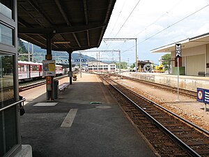
Stans railway station
Railway station in Switzerland
Distance: Approx. 137 meters
Latitude and longitude: 46.95832,8.36673111
Stans is a Swiss railway station in the municipality of Stans in the canton of Nidwalden. It is on the Luzern–Stans–Engelberg line, owned by the Zentralbahn railway company.

Dallenwil railway station
Railway station in Switzerland
Distance: Approx. 3276 meters
Latitude and longitude: 46.93377,8.39205111
Dallenwil railway station is a Swiss railway station in the municipality of Dallenwil in the canton of Nidwalden. It is on the Luzern–Stans–Engelberg line, owned by the Zentralbahn railway company.

Buochs Airport
Airport
Distance: Approx. 3037 meters
Latitude and longitude: 46.97444444,8.39694444
The Buochs Airport (IATA code BXO) (ICAO code LSZC Mil: LSMU) is a regional airport in the town of Buochs in the Canton of Nidwalden in Switzerland. It has a concrete runway with a length of 2000 meters and a width of 40 meters, several taxiways and hangars.
Rotzberg Castle
Distance: Approx. 2374 meters
Latitude and longitude: 46.964207,8.336464
Rotzberg or Rotzburg is a ruined castle in the municipality of Ennetmoos in the canton of Nidwalden in Switzerland.
Weather in this IP's area
fog
10 Celsius
10 Celsius
9 Celsius
12 Celsius
1018 hPa
97 %
1018 hPa
966 hPa
10000 meters
1.03 m/s
07:50:21
18:32:13