Country:
 Denmark
Region:
City:
Latitude and Longitude:
Time Zone:
Postal Code:
IP information under different IP Channel
ip-api
Country
Region
City
ASN
Time Zone
ISP
Blacklist
Proxy
Latitude
Longitude
Postal
Route
IPinfo
Country
Region
City
ASN
Time Zone
ISP
Blacklist
Proxy
Latitude
Longitude
Postal
Route
MaxMind
Country
Region
City
ASN
Time Zone
ISP
Blacklist
Proxy
Latitude
Longitude
Postal
Route
Luminati
Country
DKASN
Time Zone
Europe/Copenhagen
ISP
GlobalConnect A/S
Latitude
Longitude
Postal
db-ip
Country
Region
City
ASN
Time Zone
ISP
Blacklist
Proxy
Latitude
Longitude
Postal
Route
ipdata
Country
Region
City
ASN
Time Zone
ISP
Blacklist
Proxy
Latitude
Longitude
Postal
Route
Popular places and events near this IP address
Technical University of Denmark
Public technical university in Kongens Lyngby, Denmark
Distance: Approx. 1657 meters
Latitude and longitude: 55.78583333,12.52138889
The Technical University of Denmark (Danish: Danmarks Tekniske Universitet), often simply referred to as DTU, is a polytechnic university and school of engineering. It was founded in 1829 at the initiative of Hans Christian Ørsted as Denmark's first polytechnic, and it is today ranked among Europe's leading engineering institutions. It is located in the town Kongens Lyngby, 12 kilometres (7.5 mi) north of central Copenhagen, Denmark.

Nærum Line
Railway line in Copenhagen, Denmark
Distance: Approx. 1120 meters
Latitude and longitude: 55.8093,12.527
Nærumbanen is a short railway line in the northern suburbs of Copenhagen which serves mainly local neighborhoods in Kongens Lyngby in Lyngby-Taarbæk Municipality and Nærum in Rudersdal municipality. It is currently operated by the railway company Lokaltog A/S. Lokaltog runs frequent light trains that connect to the S-train system at Jægersborg. Nærumbanen, or Jægersborg-Nærum Railway, is a local railway, originally between Lyngby and Vedbæk, now between Jægersborg and Nærum.

Lundtofte
Neighbourhood in Lyngby-Taarbæk, Capital Region, Denmark
Distance: Approx. 445 meters
Latitude and longitude: 55.79861111,12.52416667
Lundtofte is a neighbourhood in Lyngby-Taarbæk Municipality, located north of Kongens Lyngby. The town is bordered by Nærumbanen, the Mølleåen river, the Technical University of Denmark and the Helsingørmotorvejen. DTU is situated on the location of the former Lundtofte Flyveplads.
Brede, Denmark
Neighbourhood in Lyngby-Taarbæk, Capital Region, Denmark
Distance: Approx. 1173 meters
Latitude and longitude: 55.7925,12.506
Brede is a neighbourhood (Danish: bydel, a named neighbourhood) 14 km north of Copenhagen, Denmark. It is located east of Virum, south of Ørholm, west of Lundtofte and north of Sorgenfri. Frilandsmuseet (The Open Air Museum), and the heritage-listed former industrial complex Brede Works, are located in Brede.
Brede Works
Distance: Approx. 1348 meters
Latitude and longitude: 55.79472222,12.49916667
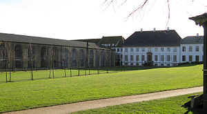
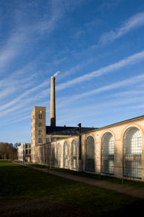
The National Museum of Denmark's new museum, Brede Works, lies in the countryside just north of Copenhagen in Denmark's largest, protected industrial plants. At the museum of Industrial culture, the visitors can be guided around by its own virtual person between old machines, hear how Denmark became an industrial society and even try to work at an assembly line. The exhibitions show the industrial development which has changed the everyday lives of the Danes over the past few centuries.
Mølleåen
Distance: Approx. 497 meters
Latitude and longitude: 55.80416667,12.52277778
Mølleåen, also Mølleå, sometimes translated as the Millstream, is a small river in North Zealand, Denmark, which runs 36 kilometres (22 mi) from the west of Bastrup Sø near Lynge to the Øresund between Taarbæk and Skodsborg. The valley contains several country houses and a series of mills which initiated Denmark's industrial development.

Ørholm
Neighbourhood in Lyngby-Taarbæk, Capital Region, Denmark
Distance: Approx. 770 meters
Latitude and longitude: 55.8003,12.5057
Ørholm is a neighbourhood and locality on the Mølleåen river in Lyngby-Taarbæk Municipality in the northern suburbs of Copenhagen9, Denmark. Ørholm Watermill has a history that dates back to at least the 15th century but the current industrial buildings were constructed after fires in 1886 and 1913. Ørholm House, a residence dating from the mid-18th century, is privately owned and heritage listed.
Lundtofte Flyveplads
Airport in Lundtofte, Denmark
Distance: Approx. 1504 meters
Latitude and longitude: 55.78722222,12.52138889
Lundtofte Flyveplads (Lundtofte Aerodrome) is a former airport for both military and civilian use. Currently, the Technical University of Denmark (DTU) is built on the site. The airport opened in 1917 and the last flight was in 1959.
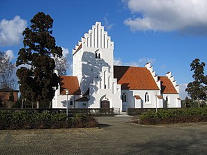
Lundtofte Church
Church in Kongens Lyngby, Denmark
Distance: Approx. 742 meters
Latitude and longitude: 55.79393889,12.51830833
Lundtofte Church (Danish: Lundtofte Kirke) is a Church of Denmark parish church in Lyngby-Taarbæk Municipality in the northern suburbs of Copenhagen, Denmark. It was completed in 1921 but is built in the style of a typical Danish white-washed village church.
Hjortekær
Neighbourhood in Lyngby-Taarbæk, Capital Region, Denmark
Distance: Approx. 1536 meters
Latitude and longitude: 55.79222222,12.5375
Hjortekær is a neighbourhood in Lyngby-Taarbæk Municipality, in the Region Hovedstaden. It is located north of Fortunen, east of Lundtofte and west of Jægersborg Dyrehave. The Technical University of Denmark has used localities in Hjortekær for surveying education since 1890.
Ravnholm
Neighbourhood in Lyngby-Taarbæk, Capital Region, Denmark
Distance: Approx. 361 meters
Latitude and longitude: 55.8033,12.5212
Ravnholm is a neighbourhood in Lyngby-Taarbæk Municipality, located north of Copenhagen. It is located north of Lundtofte and east of Ørholm, bordering Ravnholm Forest in Rudersdal Municipality to the north. IBM has an office building in Ravnholm, the building built in 1991 by architects Jørgen Bo, Anders Hegelund and PLH Arkitekter.

Nærum railway station
Railway station in Rudersdal Municipality, Denmark
Distance: Approx. 1611 meters
Latitude and longitude: 55.81388889,12.52819444
Nærum station is a railway station serving the suburb of Nærum north of Copenhagen in North Zealand, Denmark. Nærum station is the northern terminus of the Nærum railway line from Jægersborg to Nærum. The first Nærum station was opened in 1900 with the opening of the railway line between Kongens Lyngby and Vedbæk.
Weather in this IP's area
clear sky
13 Celsius
12 Celsius
11 Celsius
14 Celsius
1027 hPa
87 %
1027 hPa
1024 hPa
10000 meters
3.57 m/s
7.35 m/s
10 degree
6 %
06:44:12
19:25:24