Country:
 Germany
Region:
City:
Latitude and Longitude:
Time Zone:
Postal Code:
IP information under different IP Channel
ip-api
Country
Region
City
ASN
Time Zone
ISP
Blacklist
Proxy
Latitude
Longitude
Postal
Route
IPinfo
Country
Region
City
ASN
Time Zone
ISP
Blacklist
Proxy
Latitude
Longitude
Postal
Route
MaxMind
Country
Region
City
ASN
Time Zone
ISP
Blacklist
Proxy
Latitude
Longitude
Postal
Route
Luminati
Country
DERegion
he
City
badkonig
ASN
Time Zone
Europe/Berlin
ISP
ENTEGA Medianet GmbH
Latitude
Longitude
Postal
db-ip
Country
Region
City
ASN
Time Zone
ISP
Blacklist
Proxy
Latitude
Longitude
Postal
Route
ipdata
Country
Region
City
ASN
Time Zone
ISP
Blacklist
Proxy
Latitude
Longitude
Postal
Route
Popular places and events near this IP address
Odenwaldkreis
District in Hesse, Germany
Distance: Approx. 8632 meters
Latitude and longitude: 49.6634,8.99402
The Odenwaldkreis is a Kreis (district) in the south of Hesse, Germany. Neighboring districts are Darmstadt-Dieburg, Miltenberg, Neckar-Odenwald-Kreis, Rhein-Neckar-Kreis and Kreis Bergstraße. Odenwaldkreis belongs to the Rhine Neckar Area.

Michelstadt
Town in Hesse, Germany
Distance: Approx. 6949 meters
Latitude and longitude: 49.678591,9.003859
Michelstadt (German: [ˈmɪçl̩ˌʃtat] ) in the Odenwald is a town in the Odenwaldkreis (district) in southern Hesse, Germany between Darmstadt and Heidelberg. It has a population of 28,629 people.

Höchst im Odenwald
Municipality in Hesse, Germany
Distance: Approx. 6581 meters
Latitude and longitude: 49.8,9
Höchst im Odenwald (officially Höchst i. Odw.) is a municipality in the Odenwaldkreis (district) in Hesse, Germany.

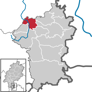
Bad König
Town in Hesse, Germany
Distance: Approx. 1688 meters
Latitude and longitude: 49.75,9.01666667
Bad König (German: [baːt ˈkøːnɪç] ) is a town and resort (Kurort) in the central Odenwald in the Odenwaldkreis (district) in Hesse, Germany, 29 km southeast of Darmstadt.
Brensbach
Municipality in Hesse, Germany
Distance: Approx. 8725 meters
Latitude and longitude: 49.76666667,8.88333333
Brensbach is a municipality in the Odenwaldkreis (district) in Hesse, Germany.
Brombachtal
Municipality in Hesse, Germany
Distance: Approx. 2400 meters
Latitude and longitude: 49.73333333,8.96666667
Brombachtal is a municipality in the Odenwaldkreis (district) in Hesse, Germany.
Lützelbach
Municipality in Hesse, Germany
Distance: Approx. 7671 meters
Latitude and longitude: 49.78833333,9.07527778
Lützelbach (German pronunciation: [lʏtsəlˌbax]ˈ) is a municipality in the Odenwaldkreis (district) in Hesse, Germany.

Morsberg
Distance: Approx. 8555 meters
Latitude and longitude: 49.7075,8.89083333
Morsberg is a hill in the Rhön range in Hesse, Germany.

Erdbach
River in Germany
Distance: Approx. 7775 meters
Latitude and longitude: 49.67111111,8.99361111
Erdbach is a small river of Hesse, Germany. It flows into the Mümling near Michelstadt.
Hollerbach (Brensbach)
River in Germany
Distance: Approx. 8571 meters
Latitude and longitude: 49.7729,8.8895
Hollerbach is a small river of Hesse, Germany. It flows into the Brensbach near the village Brensbach.

Kinzig (Mümling)
River in Germany
Distance: Approx. 2098 meters
Latitude and longitude: 49.7597,8.9959
Kinzig is a small river of Hesse, Germany. It flows into the Mümling near Bad König.

Brombach (Mümling)
River in Germany
Distance: Approx. 1905 meters
Latitude and longitude: 49.724,8.9937
Brombach is a river of Hesse, Germany. The Brombach springs from several sources west of Rehbach (a district of Michelstadt) and of Langen-Brombach (a district of Brombachtal). In the district Zell im Odenwald of Bad König, it discharges into the Mümling.
Weather in this IP's area
light rain
16 Celsius
16 Celsius
15 Celsius
16 Celsius
1004 hPa
95 %
1004 hPa
983 hPa
10000 meters
2.68 m/s
3.13 m/s
117 degree
100 %
07:34:49
18:47:50