Country:
Region:
City:
Latitude and Longitude:
Time Zone:
Postal Code:
IP information under different IP Channel
ip-api
Country
Region
City
ASN
Time Zone
ISP
Blacklist
Proxy
Latitude
Longitude
Postal
Route
Luminati
Country
ASN
Time Zone
Europe/Berlin
ISP
Tele Columbus AG
Latitude
Longitude
Postal
IPinfo
Country
Region
City
ASN
Time Zone
ISP
Blacklist
Proxy
Latitude
Longitude
Postal
Route
db-ip
Country
Region
City
ASN
Time Zone
ISP
Blacklist
Proxy
Latitude
Longitude
Postal
Route
ipdata
Country
Region
City
ASN
Time Zone
ISP
Blacklist
Proxy
Latitude
Longitude
Postal
Route
Popular places and events near this IP address

Berlin Jungfernheide station
Railway station in Berlin
Distance: Approx. 1079 meters
Latitude and longitude: 52.53,13.299
Berlin Jungfernheide is a railway station located at Charlottenburg-Nord, in the Charlottenburg-Wilmersdorf district of Berlin, served by the S-Bahn lines S41 and S42, the U-Bahn line U7 and Regional-Express trains of the Deutsche Bahn. Its name literally translates into "maidens' heathland"; it was named after the Jungfernheide, a former large forest in the proximity of this station.
Mierendorffplatz (Berlin U-Bahn)
Station of the Berlin U-Bahn
Distance: Approx. 619 meters
Latitude and longitude: 52.52638889,13.305
Mierendorffplatz is a station on the Berlin U-Bahn U7 line in Charlottenburg. It was opened on 1 October 1980 with the line's extension from Richard-Wagner-Platz to Rohrdamm. The eponymous square is named after politician and Resistance fighter Carlo Mierendorff (1897–1943).

Gesellschaft zur Verfolgung von Urheberrechtsverletzungen e.V.
Distance: Approx. 1003 meters
Latitude and longitude: 52.52398333,13.32811111
The Gesellschaft zur Verfolgung von Urheberrechtsverletzungen e.V. (GVU, Society for the Prosecution of Copyright Infringement) is a registered association under German law. According to its own description it works for the video game industry and film industry and helps to protect intellectual property and to counter the illegal distribution of copied materials. For this purpose, the association cooperates with the Motion Picture Association of America (MPAA, now the MPA).
Tele Columbus
Distance: Approx. 513 meters
Latitude and longitude: 52.52587057,13.32147831
Tele Columbus is a large internet service provider in Germany with 3.6 million connected households via its Tier 3 network. Tele Columbus' services have been offered under the newly created umbrella brand PŸUR since September 2017.

Landgericht Berlin
Regional court in Berlin
Distance: Approx. 1116 meters
Latitude and longitude: 52.52707,13.29762
The Landgericht Berlin is a regional court in Berlin, divided into two divisions for civil and criminal cases. In the German court hierarchy, it is above the eleven local courts (Amtsgerichte) of the city and below the Kammergericht, which is the highest regional court of Berlin. The Landgericht Berlin is the largest Landgericht in Germany, with about 900 employees.

Westhafen Canal
Distance: Approx. 1006 meters
Latitude and longitude: 52.53472222,13.30666667
The Westhafen Canal, or Westhafenkanal in German, is a canal in Berlin, Germany. The 3.1-kilometre (1.9 mi) long canal connects with the Westhafen inland port and the Berlin-Spandau Ship Canal at its eastern end, and with the River Spree in Charlottenburg at its western end. It has no locks.

Charlottenburg Canal
Distance: Approx. 131 meters
Latitude and longitude: 52.52805556,13.31444444
The Charlottenburg Canal, or Charlottenburger Verbindungskanal in German, is a canal in Berlin, Germany. With a former length of 3.2 kilometres (2.0 mi), the canal was built between 1848 and 1859, and originally connected the River Spree, in Charlottenburg, with the Berlin-Spandau Ship Canal. The route of canal was north from the River Spree until it passed under the railway bridge carrying the Ringbahn, at which point it turned east along an alignment slightly to the south of that of the more recent Westhafen Canal.

Charlottenburg Town Hall
Distance: Approx. 1081 meters
Latitude and longitude: 52.51777778,13.30861111
Charlottenburg Town Hall (German: Rathaus Charlottenburg) is an administrative building situated in the Charlottenburg locality of Berlin in Germany. It was built between 1899 and 1905 at the behest of the then independent city of Charlottenburg in the Prussian province of Brandenburg.

AEG turbine factory
Factory in Berlin designed by Peter Behrens
Distance: Approx. 719 meters
Latitude and longitude: 52.52833333,13.32444444
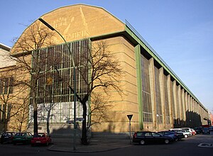
The AEG turbine factory was built in 1909, at Huttenstraße 12–16 in the Moabit district of Berlin. It is the best-known work of architect Peter Behrens. The 100 m long steel-framed building with 15 m tall glass windows on either side is considered the first attempt to introduce restrained modern design to industrial architecture.

Siegessäulen
Pair of statues on columns in Berlin, Germany
Distance: Approx. 1213 meters
Latitude and longitude: 52.52129,13.29875
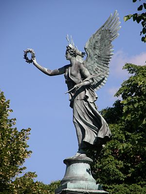
The two Siegessäulen (English: Two Victory Columns) is a pair of outdoor columns surmounted by bronze statues of Victoria, the goddess of victory. They were made in 1840 by the German sculptor Christian Daniel Rauch and installed in the park of Charlottenburg Palace in Berlin, Germany, in front of the west façade of the Neuer Pavillon.

Reformation Church
Church in Berlin, Germany
Distance: Approx. 1106 meters
Latitude and longitude: 52.53111111,13.32888889
The Reformation Church is a Lutheran church that was constructed in Moabit, a neighborhood of Berlin, Germany, between 1905 and 1907. The church's steeple, originally topped by a steep spire, was damaged during the Bombing of Berlin in World War II and replaced by a simple and much shorter spire. It is a listed building and a prominent landmark in western Moabit, the so-called Beusselkiez.
Richard Wagner Platz (Berlin)
Town square in Berlin, Germany
Distance: Approx. 1198 meters
Latitude and longitude: 52.5173,13.3061
Richard Wagner Platz (formerly: Wilhelmplatz) is in Berlin's Charlottenburg district of Charlottenburg-Wilmersdorf. Today, the former market place is mainly perceived as a traffic junction, only a small segment of the square towards Schustehrusstraße is regularly used for weekly market purposes.
Weather in this IP's area
overcast clouds
6 Celsius
1 Celsius
5 Celsius
7 Celsius
1005 hPa
83 %
1005 hPa
1001 hPa
10000 meters
8.94 m/s
13.86 m/s
261 degree
97 %
07:32:44
16:11:04
