185.89.93.77 - IP Lookup: Free IP Address Lookup, Postal Code Lookup, IP Location Lookup, IP ASN, Public IP
Country:
 Norway
Region:
City:
Location:
Time Zone:
Postal Code:
ISP:
ASN:
language:
User-Agent:
Proxy IP:
Blacklist:
IP information under different IP Channel
ip-api
Country
Region
City
ASN
Time Zone
ISP
Blacklist
Proxy
Latitude
Longitude
Postal
Route
db-ip
Country
Region
City
ASN
Time Zone
ISP
Blacklist
Proxy
Latitude
Longitude
Postal
Route
IPinfo
Country
Region
City
ASN
Time Zone
ISP
Blacklist
Proxy
Latitude
Longitude
Postal
Route
IP2Location
185.89.93.77Country
noRegion
vestfold og telemark
City
larvik
Time Zone
Europe/Oslo
ISP
Language
User-Agent
Latitude
Longitude
Postal
ipdata
Country
Region
City
ASN
Time Zone
ISP
Blacklist
Proxy
Latitude
Longitude
Postal
Route
Popular places and events near this IP address
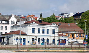
Larvik Station
Railway station in Larvik, Norway
Distance: Approx. 419 meters
Latitude and longitude: 59.05,10.03166667
Larvik Station (Norwegian: Larvik stasjon) is a railway station at Larvik in Vestfold, Norway. The station is served with regional trains operated by Vy. The station operated as part of the Vestfold Line (Vestfoldbanen).

Jotron Arena Larvik
Indoor arena in Larvik, Vestfold, Norway
Distance: Approx. 1063 meters
Latitude and longitude: 59.050362,10.052869
Jotron Arena Larvik is an indoor arena in Larvik, Norway. It was opened in September 2009. The arena will be primarily used for handball, but the hall has additional permanent floor marks for basketball, volleyball and floorball.
Lovisenlund
Distance: Approx. 879 meters
Latitude and longitude: 59.0605,10.0289
Lovisenlund is a multi-purpose stadium in Larvik, Norway. It is the home ground of Larvik Turn. The record attendance is about 17,000, from a 1956 match between Larvik Turn and Fredrikstad FK. It was used for the Norwegian football cup final of 1931, when Odd played Mjøndalen IF. The venue hosted the Norwegian Athletics Championships in 1979.
Farriseidet
Distance: Approx. 1123 meters
Latitude and longitude: 59.05,10.01666667
Farriseidet is a moraine located in the northwestern part of the town center of Larvik, Norway. It separates Larvikfjorden from the lake of Farris.

Bøkeskogen
Distance: Approx. 856 meters
Latitude and longitude: 59.05833333,10.02388889
Bøkeskogen ("The Beech Tree Forest") stretches inwards along Farris Lake in Larvik. It is an archeological area which is home to between 83, 90, and 100 burial mounds. It contains Vestfold County's largest burial grounds from the Pre-Roman Iron Age.
Norsk Soyamelfabrikk
Defunct soy processing factory in Norway
Distance: Approx. 995 meters
Latitude and longitude: 59.04555556,10.04388889
Norsk Soyamelfabrikk ('Norwegian Soy Flour Factory') was a soy flour manufacturing company in Larvik, Norway. It was the first soy flour plant in Norway. The factory was in operation between 1933 and 1977.
Fram Stadion
Football stadium in Larvik, Norway
Distance: Approx. 1095 meters
Latitude and longitude: 59.0488,10.0522
Fram Stadion is a football stadium in Larvik, Norway. It is used by IF Fram Larvik.

Thor Heyerdahl Upper Secondary School
Upper secondary school in Larvik, Norway
Distance: Approx. 1292 meters
Latitude and longitude: 59.04972222,10.05666667
Thor Heyerdahl Upper Secondary School (Norwegian: Thor Heyerdahl videregående skole) is an upper secondary school in Larvik, Norway, named for the explorer Thor Heyerdahl, who was born in the city. It was formed by combining the previous upper secondary schools in Larvik. It is one of the largest upper secondary schools in Norway, with approximately 1,650 students as of December 2013, and offers 10 programmes or courses of instruction.

Larvik (town)
Town in Larvik, Norway
Distance: Approx. 3 meters
Latitude and longitude: 59.05328,10.03518
is a town/city in Larvik Municipality in Vestfold county, Norway. The town is the administrative centre of the large municipality which stretches inland for over 50 kilometres (31 mi) from the coast. The town is located near the Skaggerak coast, wedged between the Larviksfjorden to the south, the lake Farris to the north, and the river Lågen along the east side of the town.

Farrisbrua
Bridge in Larvik, Norway
Distance: Approx. 1440 meters
Latitude and longitude: 59.05652,10.010844
The Farrisbrua (Farris Bridge) is a major road bridge crossing the Farris lake just north of Larvik, Norway. The bridge is part of the expansion of the E18 motorway from the antiquated single carriageway to modern dual carriageway standards, enabling increased speeds and traffic volumes between the eastern and southern parts of the country. It was built between 2013 and 2018, to a cost of 718 million NOK (excl.
Tollerodden
Peninsula in Larvik, Norway
Distance: Approx. 701 meters
Latitude and longitude: 59.047,10.035
Tollerodden (spelled Tolderodden until 1917) is a peninsula located in the bottom of the Larviksfjorden and a part of the town of Larvik in Larvik Municipality in Vestfold county, along the southeast coast of Norway. The Larviksfjorden is open in the southeast, so Tollerodden was the safest place in Larvik harbour, and thus the town originally started at Tollerodden and the nearby surroundings. As the town of Larvik grew, the commercial harbour was moved further out the fjord to the south and Tollerodden is preserved to look like it was in the town's early years.

Larvik Church
Church in Vestfold, Norway
Distance: Approx. 721 meters
Latitude and longitude: 59.0468225,10.035308
Larvik Church (Norwegian: Larvik kirke) is a parish church of the Church of Norway in Larvik Municipality in Vestfold county, Norway. It is located in the town of Larvik, right along the shore of the Larviksfjorden. It is one of the churches for the Larvik parish and the seat of the Larvik prosti (deanery) in the Diocese of Tunsberg.
Weather in this IP's area
broken clouds
-6 Celsius
-10 Celsius
-6 Celsius
-6 Celsius
1030 hPa
92 %
1030 hPa
1025 hPa
10000 meters
3.09 m/s
20 degree
75 %