Country:
Region:
City:
Latitude and Longitude:
Time Zone:
Postal Code:
IP information under different IP Channel
ip-api
Country
Region
City
ASN
Time Zone
ISP
Blacklist
Proxy
Latitude
Longitude
Postal
Route
Luminati
Country
ASN
Time Zone
Asia/Jerusalem
ISP
Latitude
Longitude
Postal
IPinfo
Country
Region
City
ASN
Time Zone
ISP
Blacklist
Proxy
Latitude
Longitude
Postal
Route
db-ip
Country
Region
City
ASN
Time Zone
ISP
Blacklist
Proxy
Latitude
Longitude
Postal
Route
ipdata
Country
Region
City
ASN
Time Zone
ISP
Blacklist
Proxy
Latitude
Longitude
Postal
Route
Popular places and events near this IP address

Rijswijk
Town and municipality in South Holland, Netherlands
Distance: Approx. 2104 meters
Latitude and longitude: 52.03333333,4.31666667
Rijswijk (Dutch: [ˈrɛisʋɛik] ), formerly known as Ryswick ( RIZ-wik) in English, is a town and municipality in the western Netherlands, in the province of South Holland. Its population was 59.642 in 2024, and it has an area of 14.49 km2 (5.59 sq mi), 0.53 km2 (0.20 sq mi) of which is water. The municipality also includes the former hamlets of 't Haantje and Sion, currently also known as RijswijkBuiten.

Wateringen
Place in South Holland, Netherlands
Distance: Approx. 1859 meters
Latitude and longitude: 52.01666667,4.26666667
Wateringen is a village in the Dutch province of South Holland. It is a part of the municipality of Westland, and lies about 5 km southwest of The Hague. Until 2004 it was a separate municipality and covered an area of 8.93 km2.

Sion, Netherlands
Buurtschap in South Holland, Netherlands
Distance: Approx. 2370 meters
Latitude and longitude: 52.01416667,4.325
Sion is a hamlet in the Dutch municipality of Rijswijk. It is located on the border with Delft. In 1345, the monastery Sancta Maria in Monte Sion was built in this area.

Kwintsheul
Town in South Holland, Netherlands
Distance: Approx. 2969 meters
Latitude and longitude: 52.01666667,4.25
Kwintsheul is a village in the Dutch province of South Holland. It is a part of the municipality of Westland, and lies about 2 km southwest of the border of The Hague. The statistical area "Kwintsheul", which also can include the surrounding countryside, has a population of around 3360 people.

Hoog en Woud Harnasch
Former Dutch municipality
Distance: Approx. 2692 meters
Latitude and longitude: 52.002981,4.31767
Hoog en Woud Harnasch is a former municipality in the Dutch province of South Holland. It was located to the west of the city of Delft. The municipality existed between 1817 and 1833, when it became part of Hof van Delft.

't Woudt
Place in South Holland, Netherlands
Distance: Approx. 2900 meters
Latitude and longitude: 51.99555556,4.29361111
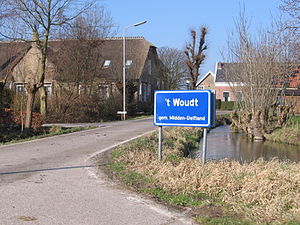
't Woudt is a small village in the Dutch province of South Holland. It is located about 5 km southwest of the city of Delft, in the municipality of Midden-Delfland. 't Woudt (then spelled "'t Woud") was a separate municipality between 1812 and 1817, when it was divided into Groeneveld, Hoog en Woud Harnasch, and a part that merged with Hof van Delft.

Rijswijk railway station
Station in the Netherlands
Distance: Approx. 2720 meters
Latitude and longitude: 52.03944444,4.31972222
Rijswijk is a railway station located in Rijswijk in the suburbs of The Hague, Netherlands. The station was opened on 3 June 1847 and is located on the Amsterdam–Rotterdam railway, between The Hague and Rotterdam. It was later enlarged, and then closed in 1938.
Escamp
Distance: Approx. 3193 meters
Latitude and longitude: 52.04555556,4.26694444
Escamp (Dutch pronunciation: [ˈɛskɑmp]) is a district of The Hague, Netherlands, built largely after the Second World War, on the 15th century Eskamppolders. With the addition of the Vinex neighbourhood Wateringse Veld, Escamp is the most populous district of the city; as of January 2013, it had 118,483 inhabitants. The district features one railway station: Den Haag Moerwijk.
De Broodfabriek
Distance: Approx. 3081 meters
Latitude and longitude: 52.03616,4.33084
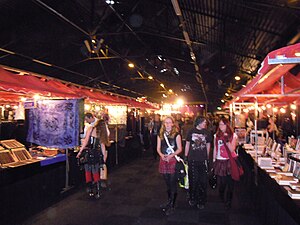
De Broodfabriek (English: The Bread Factory) is an exhibition and convention center in the Dutch city of Rijswijk. It was founded in 1996 by Henk van der Straaten (co-founder of the former Konmar supermarket chain) as the Darling Market, a recreation of the Paddy's Markets in Haymarket, near Sydney's Darling Harbour, which he encountered during a trip to Australia). In later years it became known as a venue for many fairs such as the Gothic & Fantasy Beurs (English: Gothic & Fantasy Fair) which is held there since 2003 (as of October 2018 renamed Fantasy Fest.) Since 2019 the festival has expanded from one to two music stages that host international folk artists.
Imko Binnerts (restaurant)
Restaurant in Rijswijk, Netherlands
Distance: Approx. 2826 meters
Latitude and longitude: 52.03816111,4.32386944
Imko Binnerts is a defunct restaurant located in the Grand Winston Hotel in Rijswijk, Netherlands. It was a fine dining restaurant that was awarded one Michelin star in both 2005 and 2006. Head chef of the restaurant was Imko Binnerts.

SV VELO
Dutch omnisports club
Distance: Approx. 1689 meters
Latitude and longitude: 52.03164167,4.27411111
SV VELO (short for Sportvereniging Verdedig en Loop Op) is an omnisports club from Wateringen, Netherlands. It has branches for handball, badminton, volleyball, football, checkers, boules, road cycling, and martial arts. The first squad football plays in the Eerste Klasse.
Tuinbouwschool Huis te Lande
Historic horticultural school in the Netherlands
Distance: Approx. 3182 meters
Latitude and longitude: 52.0464,4.3157
The Tuinbouwschool Huis te Lande was a horticultural school in Rijswijk, Netherlands, founded in 1907 by Jacoba Hingst. It was the first and only horticultural school for girls and women in the Netherlands to give girls the opportunity to learn how to grow flowers, fruits and vegetables, as the existing horticultural schools of that time were not accessible to them.
Weather in this IP's area
light rain
6 Celsius
6 Celsius
5 Celsius
7 Celsius
1004 hPa
88 %
1004 hPa
1004 hPa
10000 meters
0.89 m/s
2.68 m/s
121 degree
100 %
08:10:19
16:46:35

