Country:
Region:
City:
Latitude and Longitude:
Time Zone:
Postal Code:
IP information under different IP Channel
ip-api
Country
Region
City
ASN
Time Zone
ISP
Blacklist
Proxy
Latitude
Longitude
Postal
Route
Luminati
Country
Region
naq
City
lacouronne
ASN
Time Zone
Europe/Paris
ISP
IDLINE SAS
Latitude
Longitude
Postal
IPinfo
Country
Region
City
ASN
Time Zone
ISP
Blacklist
Proxy
Latitude
Longitude
Postal
Route
db-ip
Country
Region
City
ASN
Time Zone
ISP
Blacklist
Proxy
Latitude
Longitude
Postal
Route
ipdata
Country
Region
City
ASN
Time Zone
ISP
Blacklist
Proxy
Latitude
Longitude
Postal
Route
Popular places and events near this IP address

Angoumois
Place in France
Distance: Approx. 3705 meters
Latitude and longitude: 45.65,0.16666667
Angoumois (French pronunciation: [ɑ̃ɡumwa]), historically the County of Angoulême, was a county and province of France, originally inferior to the parent duchy of Aquitaine, similar to the Périgord to its east but lower and generally less forested, equally with occasional vineyards throughout. Its capital was Angoulême with its citadel and castle above the river Charente. It almost corresponds to the Charente Department which also takes in the east of the coastal comté de Saintonge.
Soyaux
Commune in Nouvelle-Aquitaine, France
Distance: Approx. 3460 meters
Latitude and longitude: 45.6414,0.1986
Soyaux (French pronunciation: [swajo] or [sojo]) is a commune in the Charente department in the Nouvelle-Aquitaine region in southwestern France.
Gond-Pontouvre
Commune in Nouvelle-Aquitaine, France
Distance: Approx. 2953 meters
Latitude and longitude: 45.6692,0.1642
Gond-Pontouvre (French pronunciation: [ɡɔ̃ pɔ̃tuvʁ]) is a commune in the Charente department in southwestern France. It is about 3 km north of the centre of Angoulême.
L'Isle-d'Espagnac
Commune in Nouvelle-Aquitaine, France
Distance: Approx. 1140 meters
Latitude and longitude: 45.6622,0.2006
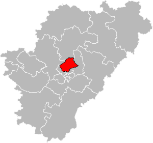
L'Isle-d'Espagnac (French pronunciation: [lil depaɲak]) is a commune in the Charente department in southwestern France.
Magnac-sur-Touvre
Commune in Nouvelle-Aquitaine, France
Distance: Approx. 2911 meters
Latitude and longitude: 45.6664,0.2383
Magnac-sur-Touvre (French pronunciation: [maɲak syʁ tuvʁ]) is a commune in the Charente department in southwestern France.
Ruelle-sur-Touvre
Commune in Nouvelle-Aquitaine, France
Distance: Approx. 1647 meters
Latitude and longitude: 45.6786,0.2211
Ruelle-sur-Touvre is a commune in the Charente department in southwestern France.

1st Marine Infantry Regiment
Military unit
Distance: Approx. 3763 meters
Latitude and longitude: 45.64416667,0.17527778
The 1st Marine Infantry Regiment (French: 1er régiment d'infanterie de marine, 1er RIMa) is a French regiment heir of the colonial infantry. The regiment is one of the quatre vieux regiments of the Troupes de Marine, with the 2nd Marine Infantry Regiment 2e RIMa, the 3rd Marine Infantry Regiment 3e RIMa, as well the 4th Marine Infantry Regiment 4e RIMa (dissolved in 1998). Along with the 1st Marine Artillery Regiment 1er RAMa and the 2nd Marine Artillery Regiment 2e RAMa, the 1st Marine formed the Blue Division.
Sentier botanique de Soyaux
Distance: Approx. 3461 meters
Latitude and longitude: 45.64138889,0.19861111
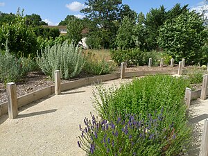
The Sentier botanique de Soyaux (200 metres long) is an arboretum and botanical path located on the Chemin de la Mothe, rue du Bourg, Soyaux, Charente, Nouvelle-Aquitaine, France. It was created in 2000 along the remains of a rural road, and planted with 42 species of regional trees and shrubs (32 deciduous, 10 evergreen). The path is open daily without charge.
Angoulême station
Distance: Approx. 3497 meters
Latitude and longitude: 45.65416667,0.16527778
Angoulême is a railway station located in Angoulême, Charente, south-western France. The station was opened in 1852 and is located on the Paris–Bordeaux railway, Saintes-Angoulême railway and Limoges-Angoulême railway. The train services are operated by SNCF. The station building is part of the former Collège Royal de la Marine, as testified by an enamel plaque in the booking hall.

Canton of Touvre-et-Braconne
Canton in Nouvelle-Aquitaine, France
Distance: Approx. 1644 meters
Latitude and longitude: 45.68,0.22
The canton of Touvre-et-Braconne is an administrative division of the Charente department, southwestern France. It was created at the French canton reorganisation which came into effect in March 2015. Its seat is in Ruelle-sur-Touvre.

Canton of Gond-Pontouvre
Canton in Nouvelle-Aquitaine, France
Distance: Approx. 3366 meters
Latitude and longitude: 45.68,0.16
The canton of Gond-Pontouvre is an administrative division of the Charente department, southwestern France. Its borders were not modified at the French canton reorganisation which came into effect in March 2015. Its seat is in Gond-Pontouvre.
Grand Angoulême
Communauté d'agglomération in Nouvelle-Aquitaine, France
Distance: Approx. 2813 meters
Latitude and longitude: 45.66666667,0.16666667
Grand Angoulême is the communauté d'agglomération, an intercommunal structure, centred on the city of Angoulême. It is located in the Charente department, in the Nouvelle-Aquitaine region, southwestern France. It was created in January 2017.
Weather in this IP's area
overcast clouds
8 Celsius
7 Celsius
7 Celsius
9 Celsius
1022 hPa
83 %
1022 hPa
1013 hPa
10000 meters
2.06 m/s
160 degree
100 %
08:01:59
17:26:44


