Country:
Region:
City:
Latitude and Longitude:
Time Zone:
Postal Code:
IP information under different IP Channel
ip-api
Country
Region
City
ASN
Time Zone
ISP
Blacklist
Proxy
Latitude
Longitude
Postal
Route
Luminati
Country
ASN
Time Zone
Europe/Berlin
ISP
SOPRADO GmbH
Latitude
Longitude
Postal
IPinfo
Country
Region
City
ASN
Time Zone
ISP
Blacklist
Proxy
Latitude
Longitude
Postal
Route
db-ip
Country
Region
City
ASN
Time Zone
ISP
Blacklist
Proxy
Latitude
Longitude
Postal
Route
ipdata
Country
Region
City
ASN
Time Zone
ISP
Blacklist
Proxy
Latitude
Longitude
Postal
Route
Popular places and events near this IP address

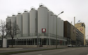
Spaten-Franziskaner-Bräu
Brewery in Munich, Germany
Distance: Approx. 334 meters
Latitude and longitude: 48.14583333,11.55333333
Spaten-Franziskaner-Bräu GmbH is a brewery in Munich, Bavaria, Germany. It produces Spaten and Franziskaner beers.

Augustiner-Bräu
Brewery in Munich, Germany
Distance: Approx. 254 meters
Latitude and longitude: 48.14305556,11.55194444
Augustiner-Bräu is a brewery in Munich, Germany, established in 1328. It is Munich's oldest independent brewery.

Bayerischer Rundfunk
Public-service radio and television broadcaster based in Munich
Distance: Approx. 373 meters
Latitude and longitude: 48.14277778,11.55361111
Bayerischer Rundfunk (pronounced [ˈbaɪʁɪʃɐ ˈʁʊntfʊŋk]; "Bavarian Broadcasting"), shortened to BR (pronounced [beːˈʔɛʁ] ), is a public-service radio and television broadcaster, based in Munich, capital city of the Free State of Bavaria in Germany. BR is a member organization of the ARD consortium of public broadcasters in Germany.

Bavarian Radio Symphony Orchestra
German radio orchestra
Distance: Approx. 335 meters
Latitude and longitude: 48.14433333,11.55380556
The Bavarian Radio Symphony Orchestra (German: Symphonieorchester des Bayerischen Rundfunks, BRSO) is a German radio orchestra. Based in Munich, Germany, it is one of the city's four orchestras. The BRSO is one of two full-size symphony orchestras operated under the auspices of Bayerischer Rundfunk, or Bavarian Broadcasting (BR).
Munich Hackerbrücke station
Munich S-Bahn station
Distance: Approx. 289 meters
Latitude and longitude: 48.14194444,11.54861111
Munich Hackerbrücke station is a station opened in 1972 on the Munich S-Bahn network below Hackerbrücke (Hacker bridge) that is close to Munich Central Station (German: Hauptbahnhof). It is classified by Deutsche Bahn as a category 3 station and has a 211 metre long central platform between two platform tracks and is located directly in front of a 3.2 percent drop into the S-Bahn trunk line tunnel. Immediately to the south is the Munich Hauptbahnhof signal box, which monitors and controls all the track work at the Central Station and on the adjoining lines (excluding the S-Bahn).

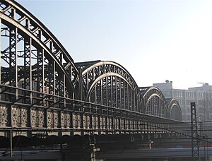
Hackerbrücke
Distance: Approx. 323 meters
Latitude and longitude: 48.14166667,11.54833333
The Hackerbrücke (Hacker Bridge) is a road bridge across the main railway line in Munich immediately west of the town's central station. The first bridge was built at the beginning of the 1870s. In 1890-94 this was replaced by a new bridge, constructed by the Maschinenfabrik Augsburg-Nürnberg ("Augsburg-Nuremberg machine factory").

War Academy (Kingdom of Bavaria)
Military training facility in Bavaria
Distance: Approx. 332 meters
Latitude and longitude: 48.14722222,11.55111111
The Bavarian War College, also Bavarian Staff College (Ge: Bayerische Kriegsakademie) was the highest military facility to educate, instruct, train, and develop general staff officers. It was active from 1867 to the beginning of World War I in 1914. For a better comparison, equivalent institutions of other countries were those like the older and ten times larger Prussian War College of the Prussian Army in Berlin or the k.u.k Kriegsschule (also a War College) of the Austrian Army in Vienna.

Circus Krone
German circus
Distance: Approx. 76 meters
Latitude and longitude: 48.145,11.55
Circus Krone, based in Munich, is one of the largest circuses in Europe and one of the few in Western Europe (along with Cirque d'hiver de Paris, Cirque d'hiver d'Amiens and Cirque Royal in Brussels) to also occupy a building.

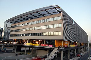
Zentraler Omnibusbahnhof München
Distance: Approx. 229 meters
Latitude and longitude: 48.1425,11.55
Zentraler Omnibusbahnhof München (ZOB München, Central bus station Munich) is a central bus station located in Maxvorstadt, Munich, Bavaria, Germany. The terminal has an area of 17,221 square metres (185,370 sq ft). The bus station was established on 11 September 2009 and is a major transportation hub for bus and train with national and international traffic.
Wittelsbacher-Gymnasium München
Distance: Approx. 157 meters
Latitude and longitude: 48.14583333,11.54861111
Wittelsbacher-Gymnasium München is located in Maxvorstadt, Munich, Bavaria, Germany.
Marsfeld (Munich)
Former military area in Munich, Germany
Distance: Approx. 222 meters
Latitude and longitude: 48.14638889,11.54833333
Marsfeld is located in Maxvorstadt, Munich, Bavaria, Germany. It is a former military area and the site of the first railway station of the city.
Augustiner-Keller
Distance: Approx. 194 meters
Latitude and longitude: 48.14352778,11.55147222
Augustiner-Keller is a traditional restaurant and beer garden in the Maxvorstadt district of Munich, Germany. The restaurant was opened in the first half of the 19th century and is one of the most popular beer gardens in Munich. Augustiner-Keller at Arnulfstraße 52 sells beer by Augustiner-Bräu, the oldest brewery in Munich.
Weather in this IP's area
clear sky
4 Celsius
4 Celsius
4 Celsius
5 Celsius
1028 hPa
97 %
1028 hPa
965 hPa
10000 meters
0.45 m/s
0.89 m/s
16 degree
9 %
07:10:17
16:44:55

