185.81.52.10 - IP Lookup: Free IP Address Lookup, Postal Code Lookup, IP Location Lookup, IP ASN, Public IP
Country:
Region:
City:
Location:
Time Zone:
Postal Code:
IP information under different IP Channel
ip-api
Country
Region
City
ASN
Time Zone
ISP
Blacklist
Proxy
Latitude
Longitude
Postal
Route
Luminati
Country
Region
ara
City
annecy
ASN
Time Zone
Europe/Paris
ISP
Celeste SAS
Latitude
Longitude
Postal
IPinfo
Country
Region
City
ASN
Time Zone
ISP
Blacklist
Proxy
Latitude
Longitude
Postal
Route
IP2Location
185.81.52.10Country
Region
auvergne-rhone-alpes
City
chamonix-mont-blanc
Time Zone
Europe/Paris
ISP
Language
User-Agent
Latitude
Longitude
Postal
db-ip
Country
Region
City
ASN
Time Zone
ISP
Blacklist
Proxy
Latitude
Longitude
Postal
Route
ipdata
Country
Region
City
ASN
Time Zone
ISP
Blacklist
Proxy
Latitude
Longitude
Postal
Route
Popular places and events near this IP address
Chamonix
Commune in Auvergne-Rhône-Alpes, France
Distance: Approx. 84 meters
Latitude and longitude: 45.9231,6.8697
Chamonix-Mont-Blanc (French pronunciation: [ʃamɔni mɔ̃ blɑ̃]; Arpitan: Chamôni-Mont-Blanc), more commonly known simply as Chamonix (Chamôni), is a commune in the Haute-Savoie department in the Auvergne-Rhône-Alpes region in Southeastern France. It was the site of the first Winter Olympics, held in 1924. Chamonix is situated in the French Alps just north of Mont Blanc, the highest mountain in Western Europe.

Arveyron
River in France
Distance: Approx. 843 meters
Latitude and longitude: 45.93083333,6.87333333
The Arveyron (French pronunciation: [aʁveʁɔ̃]) is a left tributary to the river Arve, rising in the famous Mer de Glace just above Chamonix in south-eastern France. It flows into the Arve in Chamonix. It is 4.9 km (3.0 mi) long.

Stade Olympique de Chamonix
Distance: Approx. 491 meters
Latitude and longitude: 45.92674722,6.87401111
Stade Olympique de Chamonix is an equestrian stadium in Chamonix, France. It hosted the opening and closing ceremonies to the 1924 Winter Olympics along with cross-country skiing, curling, figure skating, ice hockey, military patrol, the cross-country skiing part of the Nordic combined, and the speed skating events. The stadium holds 45,000.
FIS Alpine World Ski Championships 1962
Distance: Approx. 426 meters
Latitude and longitude: 45.92,6.87
The FIS Alpine World Ski Championships 1962 were held in France from 10 to 18 February at Chamonix in Haute-Savoie. Chamonix previously hosted the alpine world championships in 1937, and also the first Winter Olympics in 1924, but without alpine skiing, which debuted in 1936.

Les Praz
Mountain village in the French Alps
Distance: Approx. 2112 meters
Latitude and longitude: 45.93944444,6.88472222
Les-Praz-de-Chamonix (more commonly known as Les Praz) is a mountain village in the French Alps, part of the commune of Chamonix. Altitude: 1060 m (3477 ft.).

Piste de Bobsleigh des Pellerins
Distance: Approx. 971 meters
Latitude and longitude: 45.91527778,6.87194444
The Piste de Bobsleigh des Pellerins (Pellerins Bobsleigh Track in (in French)) was a bobsleigh track constructed for the 1924 Winter Olympics in Chamonix, France.

Refuge du Plan de l'Aiguille
Mountain hut in the Mont Blanc massif, France
Distance: Approx. 2266 meters
Latitude and longitude: 45.90583333,6.88305556
The Refuge du Plan de l'Aiguille is a refuge in the Mont Blanc massif in the French Alps.
Les Praz-de-Chamonix station
Railway station in Chamonix-Mont-Blanc, France
Distance: Approx. 2304 meters
Latitude and longitude: 45.93945889,6.88875306
Les Praz-de-Chamonix station (French: Gare des Praz-de-Chamonix) is a railway station in the commune of Chamonix-Mont-Blanc, in the French department of Haute-Savoie.
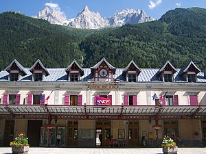
Chamonix-Mont-Blanc station
Railway station in Chamonix-Mont-Blanc, France
Distance: Approx. 354 meters
Latitude and longitude: 45.92276944,6.87363056
Chamonix-Mont-Blanc station (French: Gare de Chamonix-Mont-Blanc) is a railway station in the commune of Chamonix-Mont-Blanc, in the French department of Haute-Savoie. It is located on the 1,000 mm (3 ft 3+3⁄8 in) gauge Saint-Gervais–Vallorcine line of SNCF. The station is adjacent to the station of the Chemin de fer du Montenvers, which operates a rack railway to the Mer de Glace.
Chamonix-Aiguille-du-Midi station
Railway station in Chamonix-Mont-Blanc, France
Distance: Approx. 475 meters
Latitude and longitude: 45.91993,6.866715
Chamonix-Aiguille-du-Midi station (French: Gare de Chamonix-Aiguille-du-Midi) is a railway station in the commune of Chamonix-Mont-Blanc, in the French department of Haute-Savoie.
Les Moussoux station
Railway station in Chamonix-Mont-Blanc, France
Distance: Approx. 1129 meters
Latitude and longitude: 45.916635,6.85899
Les Moussoux station (French: Gare des Moussoux) is a railway station in the commune of Chamonix-Mont-Blanc, in the French department of Haute-Savoie.

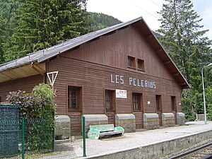
Les Pélerins station
Railway station in Chamonix-Mont-Blanc, France
Distance: Approx. 2114 meters
Latitude and longitude: 45.91256694,6.84728611
Les Pélerins station (French: Gare des Pélerins) is a railway station in the commune of Chamonix-Mont-Blanc, in the French department of Haute-Savoie.
Weather in this IP's area
overcast clouds
1 Celsius
-2 Celsius
-5 Celsius
1 Celsius
1030 hPa
92 %
1030 hPa
904 hPa
10000 meters
2.6 m/s
4.17 m/s
43 degree
87 %


