185.80.233.254 - IP Lookup: Free IP Address Lookup, Postal Code Lookup, IP Location Lookup, IP ASN, Public IP
Country:
 Netherlands
Region:
City:
Location:
Time Zone:
Postal Code:
ISP:
ASN:
language:
User-Agent:
Proxy IP:
Blacklist:
IP information under different IP Channel
ip-api
Country
Region
City
ASN
Time Zone
ISP
Blacklist
Proxy
Latitude
Longitude
Postal
Route
db-ip
Country
Region
City
ASN
Time Zone
ISP
Blacklist
Proxy
Latitude
Longitude
Postal
Route
IPinfo
Country
Region
City
ASN
Time Zone
ISP
Blacklist
Proxy
Latitude
Longitude
Postal
Route
IP2Location
185.80.233.254Country
nlRegion
noord-holland
City
diemen
Time Zone
Europe/Amsterdam
ISP
Language
User-Agent
Latitude
Longitude
Postal
ipdata
Country
Region
City
ASN
Time Zone
ISP
Blacklist
Proxy
Latitude
Longitude
Postal
Route
Popular places and events near this IP address

Diemen
Town and municipality in North Holland, Netherlands
Distance: Approx. 750 meters
Latitude and longitude: 52.33333333,4.96666667
Diemen (Dutch pronunciation: [ˈdimə(n)] ) is a town and municipality with a population of 31,334 in the province of North Holland, Netherlands. It is located approximately 6 km (3.7 mi) southeast of Amsterdam's city centre, within the Amsterdam metropolitan area.
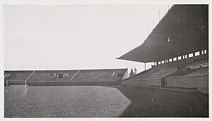
De Meer Stadion
Football stadium in Amsterdam, Netherlands
Distance: Approx. 1012 meters
Latitude and longitude: 52.34444444,4.95
De Meer Stadion (Dutch pronunciation: [də ˈmeːr ˌstaːdijɔn]) is the former stadium of Dutch record football champions Ajax. It was opened in 1934 as a result of the club's former stadium (Het Houten Stadion) being too small. Upon completion, it could hold 22,000 spectators, but accommodating up to 29,500 at its maximum.

Jaap Edenbaan
Sports park
Distance: Approx. 1591 meters
Latitude and longitude: 52.34861111,4.94444444
The Jaap Edenbaan (translated: Jaap Eden track) is an ice rink located in the Watergraafsmeer, a neighborhood of eastern Amsterdam. The rink is named after the famous Dutch ice skater Jaap Eden. It contains a 400-meter lane and Jaap Edenhal.

Diemen railway station
Railway station in the Netherlands
Distance: Approx. 698 meters
Latitude and longitude: 52.34527778,4.96694444
Diemen (abbreviation: Dmn) is the main railway station of the municipality of Diemen, Netherlands. It is located on the Amsterdam–Zutphen railway between Amsterdam Science Park and Weesp. The station was first opened in 1882 and then closed in 1929.

Diemen Zuid station
Railway and metro station in Diemen, Netherlands
Distance: Approx. 1120 meters
Latitude and longitude: 52.33027778,4.95638889
Diemen Zuid (Dutch pronunciation: [ˈdimə(n) ˈzœyt]; abbreviation: Dmnz) is a railway station is located in Diemen, a city to the southeast of Amsterdam. The railway station is served by Nederlandse Spoorwegen (NS) services as well as line 53 of the Amsterdam Metro. The station was first used as only a metro station operated by GVB in 1977.

Amsterdam Science Park railway station
Railway station in Amsterdam, Netherlands
Distance: Approx. 1723 meters
Latitude and longitude: 52.3525,4.94861111
Amsterdam Science Park is a railway station in the borough Amsterdam-Oost in Amsterdam, Netherlands. The station lies on the Amsterdam–Zutphen railway between the railway stations Amsterdam Muiderpoort and Diemen. The station serves the Science Park Amsterdam and the Watergraafsmeer, as well as Amsterdam University College and the Science Park campus of the University of Amsterdam.

Betondorp
Neighbourhood of Amsterdam in North Holland, Netherlands
Distance: Approx. 1331 meters
Latitude and longitude: 52.34027778,4.94305556
Betondorp (Dutch pronunciation: [bəˈtɔndɔr(ə)p]; Concrete Village) is a neighbourhood of Amsterdam, Netherlands. It was built in the 1920s as an experiment in building affordable housing with new, cheap building materials, chiefly concrete. The houses are built in a sober, minimalist form of Art Deco.

Jewish Cemetery of Diemen
Cemetery in Amsterdam
Distance: Approx. 1125 meters
Latitude and longitude: 52.34361111,4.97777778
The Jewish Cemetery of Diemen, or Joodse Begraafplaats Diemen in Diemen, is owned by the Jewish community of Amsterdam, which is a subsection of the "Nederlands Israëlitisch Kerkgenootschap". It came into use in 1914 when the older Jewish Cemetery Zeeburg in Amsterdam reached its limit. In 1925 the cemetery was split by a train line.

Verrijn Stuartweg metro station
Metro station in Amsterdam
Distance: Approx. 1293 meters
Latitude and longitude: 52.32833333,4.96722222
Verrijn Stuartweg is an Amsterdam Metro station in Diemen, Netherlands. It is located on the border of the industrial area and on the other side the former office district, now residential area, Bergwijkpark and Holland Park.

Jaap Edenhal
Indoor Ice Rink
Distance: Approx. 1697 meters
Latitude and longitude: 52.349916,4.944223
Jaap Edenhal (sometimes anglicized as Jaap Eden Hall) is a 4,500-capacity indoor ice rink located adjacent to Jaap Eden baan in Amsterdam, Netherlands. It is named after Dutch speed skater Jaap Eden. The Amsterdam Tigers are its primary tenant.
Real Sranang
Dutch football club
Distance: Approx. 1546 meters
Latitude and longitude: 52.34916667,4.94611111
Real Sranang (English: Royal Suriname) is an amateur association football club from Amsterdam, Netherlands, founded on 1 June 1960, that plays its home games at the Sportpark Middenmeer.
Museum tot zover
Museum in Amsterdam, Netherlands
Distance: Approx. 1785 meters
Latitude and longitude: 52.34611111,4.93861111
The Nederlands Uitvaart Museum Tot Zover (Dutch Funeral Museum So Far) is a museum in Amsterdam, Netherlands that displays the various funerary practices of the various cultures present in the Netherlands, with the view that these funerary practices provide a better understanding of these cultures. The museum is located in De Nieuwe Ooster, a memorial park in Amsterdam that includes a cemetery and crematorium. The original building was designed as a caretaker’s residence by Adriaan Willem Weissman (1858–1923), who was a Dutch city architect best known for designing the Stedelijk Museum.
Weather in this IP's area
clear sky
1 Celsius
-1 Celsius
-0 Celsius
3 Celsius
1030 hPa
69 %
1030 hPa
1030 hPa
10000 meters
2.06 m/s
110 degree