185.8.93.4 - IP Lookup: Free IP Address Lookup, Postal Code Lookup, IP Location Lookup, IP ASN, Public IP
Country:
Region:
City:
Location:
Time Zone:
Postal Code:
ISP:
ASN:
language:
User-Agent:
Proxy IP:
Blacklist:
IP information under different IP Channel
ip-api
Country
Region
City
ASN
Time Zone
ISP
Blacklist
Proxy
Latitude
Longitude
Postal
Route
db-ip
Country
Region
City
ASN
Time Zone
ISP
Blacklist
Proxy
Latitude
Longitude
Postal
Route
IPinfo
Country
Region
City
ASN
Time Zone
ISP
Blacklist
Proxy
Latitude
Longitude
Postal
Route
IP2Location
185.8.93.4Country
Region
scotland
City
ayr
Time Zone
Europe/London
ISP
Language
User-Agent
Latitude
Longitude
Postal
ipdata
Country
Region
City
ASN
Time Zone
ISP
Blacklist
Proxy
Latitude
Longitude
Postal
Route
Popular places and events near this IP address

Ayr Pavilion
Distance: Approx. 463 meters
Latitude and longitude: 55.460568,-4.640192
Ayr Pavilion (later Hanger 13) is a former music venue and multi-purpose hall in Ayr, Scotland, situated on Ayr's Low Green. As of 2020, it is used as "Pirate Pete's Family Entertainment Centre".

Ayr railway station (1839–1857)
Disused railway station in Ayr, Ayrshire
Distance: Approx. 456 meters
Latitude and longitude: 55.4666,-4.6317
Ayr railway station was a railway station serving the town of Ayr, South Ayrshire, Scotland. The station was originally part of the Glasgow, Paisley, Kilmarnock and Ayr Railway. From October 1850, it became part of the Glasgow and South Western Railway.

Ayr Academy
School in Ayr, South Ayrshire, Scotland
Distance: Approx. 226 meters
Latitude and longitude: 55.46472222,-4.63416667
Ayr Academy (Scottish Gaelic: Acadamaidh Inbhir Àir) is an 11–18 non-denominational secondary school situated within the Craigie Estate area at University Avenue in Ayr, South Ayrshire. It is the sixth largest secondary school in South Ayrshire, with a pupil roll of 607 in 2023–2024. Established during the thirteenth century in 1233, Ayr Academy is one of the oldest schools in the United Kingdom and Scotland.

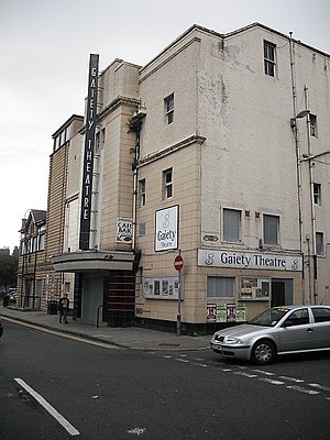
Gaiety Theatre, Ayr
Distance: Approx. 209 meters
Latitude and longitude: 55.4614,-4.6315
The Gaiety Theatre is a category B listed performing arts venue in Ayr, Scotland. It is noted for its interior rococo features, its atmosphere and its acoustics.
Ayr Castle
Castle in South Ayrshire, Scotland, UK
Distance: Approx. 275 meters
Latitude and longitude: 55.465,-4.6355
Ayr Castle was a castle situated at Ayr in Scotland. Once considered a royal castle, nothing remains of it above ground.
Barns of Ayr
Fictional site in Ayr, Scotland, used as English barracks
Distance: Approx. 454 meters
Latitude and longitude: 55.46083333,-4.6275
The Barns of Ayr was, according to Blind Harry in The Wallace, a site in Ayr, Scotland, which was used as English barracks. According to Blind Harry, a number of Scottish barons of Ayrshire were called to a meeting with King Edward I of England at a barn used as an English military barracks, only to be massacred and hanged, including Sir Ronald Crawford Sheriff of Ayr, Sir Bryce Blair of Blair, Sir Neil Montgomerie of Cassillis, Crystal of Seton, and Sir Hugh Montgomerie. In revenge, William Wallace burned the barracks with the English inside.
Montgomerieston
Village in South Ayrshire, Scotland, UK
Distance: Approx. 254 meters
Latitude and longitude: 55.46419444,-4.63694444
Montgomerieston, sometimes known as Montgomeryston (NGR NS 333 220) or Ayr Fort, was a small burgh of regality and barony of only 16 acres or 6.5 hectares located within the walls of the old Ayr Citadel, also known as Cromwell's Fort or Oliver's Fort, situated in the town of Ayr, South Ayrshire, Scotland. Montgomerieston was named for the Montgomerie family, Earls of Eglinton.

Churchill Barracks
Distance: Approx. 464 meters
Latitude and longitude: 55.46621,-4.63788
Churchill Barracks was a military installation in Ayr, Scotland.

Wellington Square drill hall, Ayr
Distance: Approx. 289 meters
Latitude and longitude: 55.46091,-4.63721
The Wellington Square drill hall was a military installation in Ayr.

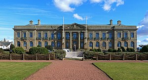
Ayr Town Hall
Municipal Building in Ayr, Scotland
Distance: Approx. 209 meters
Latitude and longitude: 55.4642,-4.6319
Ayr Town Hall is a municipal building in New Bridge Street, Ayr, Scotland. The town hall, which was the headquarters of Ayr Burgh Council, is a Category A listed building.

County Buildings, Ayr
County building in Ayr, Scotland
Distance: Approx. 335 meters
Latitude and longitude: 55.4613,-4.6386
County Buildings is a municipal complex in Wellington Square, Ayr, Scotland which serves as the headquarters and main meeting place of South Ayrshire Council. The original structure, the former sheriff court at the eastern end of the complex, is Category A listed building, while the main office building at the western end of the complex, is a Category B listed building.

Ayr Lifeboat Station
Former lifeboat station in South Ayrshire, Scotland
Distance: Approx. 289 meters
Latitude and longitude: 55.46527778,-4.63333333
Ayr Lifeboat Station was latterly located next to the River Ayr near New Bridge, on South Harbour Street in Ayr, a harbour town and former Royal Burgh, overlooking the Firth of Clyde and the Isle of Arran, in the county of South Ayrshire, historically Ayrshire, on the south-west coast of Scotland. A lifeboat was first stationed at Ayr, by the Ayr Harbour Commissioners. The management of the station transferred to the Royal National Lifeboat Institution (RNLI) in 1859.
Weather in this IP's area
few clouds
6 Celsius
3 Celsius
4 Celsius
6 Celsius
972 hPa
91 %
972 hPa
965 hPa
10000 meters
4.63 m/s
110 degree
20 %