Country:
Region:
City:
Latitude and Longitude:
Time Zone:
Postal Code:
IP information under different IP Channel
ip-api
Country
Region
City
ASN
Time Zone
ISP
Blacklist
Proxy
Latitude
Longitude
Postal
Route
Luminati
Country
ASN
Time Zone
Asia/Yerevan
ISP
House Net LLC
Latitude
Longitude
Postal
IPinfo
Country
Region
City
ASN
Time Zone
ISP
Blacklist
Proxy
Latitude
Longitude
Postal
Route
db-ip
Country
Region
City
ASN
Time Zone
ISP
Blacklist
Proxy
Latitude
Longitude
Postal
Route
ipdata
Country
Region
City
ASN
Time Zone
ISP
Blacklist
Proxy
Latitude
Longitude
Postal
Route
Popular places and events near this IP address

Armavir Province
Province of Armenia
Distance: Approx. 5709 meters
Latitude and longitude: 40.15,44.05
Armavir (Armenian: Արմավիր, Armenian pronunciation: [ɑɾmɑˈviɾ] ), is a province (marz) in the western part of Armenia. Located in the Ararat plain dominated by Mount Ararat from the south and Mount Aragats from the north, the province's capital is the town of Armavir while the largest city is Vagharshapat (Etchmiadzin). The province shares a 72 km (45 mi)-long border with Turkey to the south and west.

Metsamor
Place in Armavir, Armenia
Distance: Approx. 194 meters
Latitude and longitude: 40.14277778,44.11638889
Metsamor (Armenian: Մեծամոր, Armenian pronunciation: [mɛt͡sɑˈmoɾ]), is a town and urban municipal community in the Armavir Province of Armenia. It is famous for being home to Armenia's Metsamor Nuclear Power Plant, the only nuclear plant in the Transcaucasian region. As of the 2011 census, the town had a population of 9,191.

Armenian Nuclear Power Plant
Nuclear power plant near Yerevan, Armenia
Distance: Approx. 4886 meters
Latitude and longitude: 40.18084444,44.14890833
The Armenian Nuclear Power Plant (ANPP) (Armenian: Հայկական ատոմային էլեկտրակայան), also known as the Metsamor Nuclear Power Plant, (Armenian: Մեծամորի ատոմային էլեկտրակայան) is the only nuclear power plant in the South Caucasus, located 36 kilometers west of Yerevan in Armenia. The ANPP complex consists of two VVER-440 Model V270 nuclear reactors, each capable of generating 407.5 megawatts (MW) of power, for a total of 815 MW. The plant supplied approximately 40 percent of Armenia's electricity in 2015. As with other early VVER-440 plants, and unlike Western pressurized water reactors (PWR), the ANPP lacks a secondary containment building.
Aknalich
Place in Armavir, Armenia
Distance: Approx. 3758 meters
Latitude and longitude: 40.14055556,44.16055556
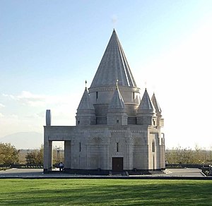
Aknalich (or Aknalitch, Armenian: Ակնալիճ; formerly, Aygherlich) is a village in the Armavir Province of Armenia. The village is situated on a lake, after which it is named, to the east of Metsamor. Aknalich village is the site of the only Yazidi temple in Armenia.
Arevik
Place in Armavir, Armenia
Distance: Approx. 5173 meters
Latitude and longitude: 40.10055556,44.09694444
Arevik (Armenian: Արևիկ; formerly, Agdzharkh and Aghja-Arkh) is a town in the Armavir province of Armenia. The name Arevik comes from the root Arev meaning "sun".
Mrgashat
Place in Armavir, Armenia
Distance: Approx. 4258 meters
Latitude and longitude: 40.12972222,44.07055556
Mrgashat (Armenian: Մրգաշատ), is a major village in the Armavir Province of Armenia. A Bronze Age archaeological site is found near the village.
Azatavan, Armavir
Place in Armavir, Armenia
Distance: Approx. 4436 meters
Latitude and longitude: 40.13333333,44.06666667
Azatavan is a town in the Armavir Province of Armenia.
Verin-Kulibeklu
Place in Armavir, Armenia
Distance: Approx. 4296 meters
Latitude and longitude: 40.15,44.16666667
Verin-Kulibeklu (also, Verkhniy Kulibeklu) is a town in the Armavir Province of Armenia.
Zartonk
Place in Armavir, Armenia
Distance: Approx. 5423 meters
Latitude and longitude: 40.10916667,44.16055556
Zartonk (Armenian: Զարթոնք), is a village in the Armavir Province of Armenia. Almost 42% (around 980 individuals) of the population are from the Yazidi minority.
Mayisyan, Armavir
Place in Armavir, Armenia
Distance: Approx. 3078 meters
Latitude and longitude: 40.16166667,44.08833333
Mayisyan (Armenian: Մայիսյան), is a village in the Armavir Province of Armenia. It was founded as a collective farm (sovkhoz) and named Sovkhoz No.2. Later it became known as Imeni Beriya, named after Lavrentiy Beria.

Lake Akna (Armavir)
Distance: Approx. 4441 meters
Latitude and longitude: 40.14444444,44.16888889
Lake Akna (Armenian: Ակնա) is a small lake located in the Ararat plain west of Ejmiatsin in Armenia. The area of the lake is 0.07 km2 (0.027 sq mi), while its maximum depth is 9.4 meters.

Quba Mêrê Dîwanê
Distance: Approx. 3868 meters
Latitude and longitude: 40.1402,44.1618
Quba Mêrê Dîwanê is the world's largest Yazidi temple. It is located in the Armenian village of Aknalich, in the province of Armavir, where the Yezidis are the largest minority. The village of Aknalich is located 35 kilometers west of Yerevan, the capital of Armenia.
Weather in this IP's area
broken clouds
2 Celsius
2 Celsius
2 Celsius
6 Celsius
1024 hPa
60 %
1024 hPa
924 hPa
10000 meters
0.43 m/s
0.57 m/s
257 degree
51 %
07:48:09
17:48:03
