Country:
 Netherlands
Region:
City:
Latitude and Longitude:
Time Zone:
Postal Code:
IP information under different IP Channel
ip-api
Country
Region
City
ASN
Time Zone
ISP
Blacklist
Proxy
Latitude
Longitude
Postal
Route
IPinfo
Country
Region
City
ASN
Time Zone
ISP
Blacklist
Proxy
Latitude
Longitude
Postal
Route
MaxMind
Country
Region
City
ASN
Time Zone
ISP
Blacklist
Proxy
Latitude
Longitude
Postal
Route
Luminati
Country
NLRegion
ge
City
nijmegen
ASN
Time Zone
Europe/Amsterdam
ISP
Cyso Group B.V.
Latitude
Longitude
Postal
db-ip
Country
Region
City
ASN
Time Zone
ISP
Blacklist
Proxy
Latitude
Longitude
Postal
Route
ipdata
Country
Region
City
ASN
Time Zone
ISP
Blacklist
Proxy
Latitude
Longitude
Postal
Route
Popular places and events near this IP address
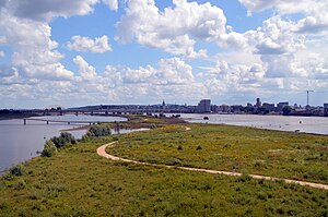
Nijmegen
City and municipality in Gelderland, Netherlands
Distance: Approx. 432 meters
Latitude and longitude: 51.8475,5.8625
Nijmegen (Dutch: [ˈnɛiˌmeːɣə(n)] ; Nijmeegs: Nimwèège [ˈnɪmβ̞ɛːçə]) is the largest city in the Dutch province of Gelderland and the tenth largest of the Netherlands as a whole. Located on the Waal River close to the German border, Nijmegen is one of the oldest cities in the Netherlands and the first to be recognized as such in Roman times. In 2005, it celebrated 2,000 years of existence.

Valkhof Museum
Distance: Approx. 770 meters
Latitude and longitude: 51.846,5.871
The Valkhof Museum (Dutch: Museum Het Valkhof) is an archaeology and art museum in Nijmegen, Netherlands. The museum has existed since 1999, created as a merger between the G. M. Kam museum of archaeology and the Commanderie van St. Jan museum of classical and modern art.
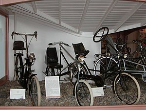
Velorama
Distance: Approx. 488 meters
Latitude and longitude: 51.84888889,5.86972222
The Velorama (Dutch: Nationaal Fietsmuseum Velorama) is the only bicycle museum in the Netherlands. It is located along the Waal River in the city of Nijmegen. The museum was founded in 1981 from the private collection of G.F. Moed.

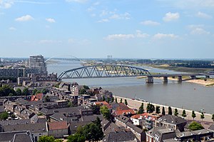
Waalbrug
Bridge in Nijmegen, Netherlands
Distance: Approx. 541 meters
Latitude and longitude: 51.85111111,5.87166667
The Waalbrug is an arch bridge over the Waal River in Nijmegen, Gelderland, the Netherlands. The full length of the Waalbrug is 604 metres (1,982 ft), the middle of the arch being about 65 metres (213 ft) high. The arch itself is 244.1 metres (801 ft) long and was the longest arch in Europe at the time of construction.
Nijmegen railway bridge
Bridge in Nijmegen, Netherlands
Distance: Approx. 500 meters
Latitude and longitude: 51.8519,5.8566
The Nijmegen railway bridge (Dutch: Spoorbrug Nijmegen) is a truss bridge spanning the River Waal in the Netherlands, connecting the city of Nijmegen to the town of Lent.

Stratemakerstoren
Distance: Approx. 505 meters
Latitude and longitude: 51.84861111,5.86972222
The Stratemakerstoren is an early 16th-century bastion on the Waalkade in the Dutch town Nijmegen. It is a rijksmonument (national heritage site) and since 1995, it housed a museum. This was closed in April 2015, for major reconstruction.

Concertgebouw de Vereeniging
Concert hall in Nijmegen, Netherlands
Distance: Approx. 1122 meters
Latitude and longitude: 51.84138889,5.86083333
Concertgebouw de Vereeniging is a concert hall located in Nijmegen, Netherlands. The facility officially opened in 1915 and is built in a mixture of Art Nouveau and Art Deco styles. It has a capacity of 1,450 seats (or 1,800 standing people during pop concerts), and is renowned for its outstanding acoustics for orchestral music.
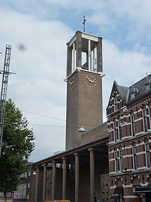
St Peter Canisius Church, Nijmegen
Distance: Approx. 721 meters
Latitude and longitude: 51.844836,5.86319
St Peter Canisius Church (Dutch: Sint-Petrus Canisiuskerk), also known as Molenstraatkerk, is a Roman Catholic Parish church in Nijmegen, Gelderland, Netherlands. It is situated on Molenstraat in the centre of the city. It is run by the Society of Jesus and is in the Diocese of 's-Hertogenbosch.
Veur-Lent
Island in the Dutch river Waal
Distance: Approx. 333 meters
Latitude and longitude: 51.8542,5.865
Veur-Lent is the name of an island in the Dutch river Waal. It is part of the municipality of Nijmegen, situated in the Lent Quarter, north of both the city center and the main channel of the Waal. Owing to the threat of dike breaches at high water, it was decided in 1995 that more water would need to flow through the river.

Siege of Knodsenburg
1591 siege of the Eighty Years' War
Distance: Approx. 401 meters
Latitude and longitude: 51.8549,5.8641
The siege of Knodsenburg, Relief of Knodzenburg or also known as Battle of the Betuwe was a military action that took place during the Eighty Years' War and the Anglo–Spanish War at a sconce known as Knodsenburg in the district of Nijmegen. A siege by a Spanish army under the command of the Duke of Parma took place from 15 to 25 July 1591. The fort was defended by the Dutch Republic's commander Gerrit de Jong and his company which was then subsequently relieved through the intervention of a Dutch and English army led by Maurice of Orange and Francis Vere, respectively, on 25 July.

Grote Broek
Self-managed political project in Nijmegen, the Netherlands
Distance: Approx. 848 meters
Latitude and longitude: 51.8438,5.866
De Grote Broek (English: The Big Trousers) is a legalised squat and self-managed social centre in central Nijmegen in the Netherlands. It was occupied in 1984 and legalised from 2002 onwards. It spans two sides of a city block and has entrances on both Van Broeckhuysenstraat and Tweede Walstraat.

Lindenberg Nijmegen Culture House
Distance: Approx. 454 meters
Latitude and longitude: 51.84852,5.868633
The Lindenberg Nijmegen Culture House, founded in 1972, was a project opened by the Netherlands Minister of Culture, Piet Engels. It is a cultural house (theatre) in Nijmegen, Netherlands, on the Ridderstraat next to the Valkhof Museum. The Lindenberg operates theatre programs, hosts performances, hosts education courses, and has a cafe.
Weather in this IP's area
overcast clouds
11 Celsius
11 Celsius
10 Celsius
12 Celsius
1024 hPa
92 %
1024 hPa
1023 hPa
10000 meters
0.45 m/s
0.89 m/s
230 degree
91 %
07:13:21
19:49:27