Country:
 Slovakia
Region:
City:
Latitude and Longitude:
Time Zone:
Postal Code:
IP information under different IP Channel
ip-api
Country
Region
City
ASN
Time Zone
ISP
Blacklist
Proxy
Latitude
Longitude
Postal
Route
IPinfo
Country
Region
City
ASN
Time Zone
ISP
Blacklist
Proxy
Latitude
Longitude
Postal
Route
MaxMind
Country
Region
City
ASN
Time Zone
ISP
Blacklist
Proxy
Latitude
Longitude
Postal
Route
Luminati
Country
SKASN
Time Zone
Europe/Bratislava
ISP
LightStorm Services s.r.o.
Latitude
Longitude
Postal
db-ip
Country
Region
City
ASN
Time Zone
ISP
Blacklist
Proxy
Latitude
Longitude
Postal
Route
ipdata
Country
Region
City
ASN
Time Zone
ISP
Blacklist
Proxy
Latitude
Longitude
Postal
Route
Popular places and events near this IP address

Tehelné pole
Stadium in Bratislava, Slovakia
Distance: Approx. 1388 meters
Latitude and longitude: 48.1636,17.1369
Tehelné pole or National football stadium (Slovak: Národný futbalový štadión) is a multi-use stadium in Bratislava, Slovakia. It was completed in 2019 and is used for football matches, including the home matches of ŠK Slovan Bratislava and the Slovakia national football team. This project concerns mutual assistance between well-known Slovak entrepreneur Ivan Kmotrík as the owner of ŠK Slovan Bratislava and the Government of Slovakia.
Apollo Arena Bratislava
Distance: Approx. 1146 meters
Latitude and longitude: 48.1625,17.141488
Apollo Arena Bratislava, also known as the Danube Arena, was a proposed a multi-use indoor arena in Bratislava, Slovakia. It was to be used mostly for ice hockey and basketball matches, as well as concerts and similar events. The 2011 IIHF World Championship was to be held in this arena, but later it was decided to renovate the old Ondrej Nepela Arena rather than to build a new stadium, as the city did not possess land in the proposed area between Apollo Bridge and Harbour Bridge on the right bank of Danube river.
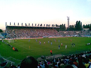
Tipos aréna
Slovakian sports arena, opened 1940
Distance: Approx. 1089 meters
Latitude and longitude: 48.16,17.13611111
The Ondrej Nepela Arena (Slovak: Zimný Štadión Ondreja Nepelu) (also known as Orange Arena during the 2011 IIHF Championship and later as Tipos Aréna, previously Slovnaft Arena, for sponsorship reasons) is an indoor arena in Bratislava, Slovakia. It is primarily used for ice hockey and it is the home arena of the HC Slovan Bratislava.

Central Baths, Bratislava
Distance: Approx. 1300 meters
Latitude and longitude: 48.15694444,17.12944444
Kupele Central (Central Baths) were public baths in the center of Bratislava, Slovakia. Construction began in the 1970s, but a decade of construction delays ensued. The facility would open in 1987 with an Olympic sized swimming pool and steam baths, and subsequently close in 1992.

Peugeot Arena
Event location in Bratislava, Slovakia
Distance: Approx. 1408 meters
Latitude and longitude: 48.16277778,17.13444444
Peugeot Arena (formerly known as AXA Aréna NTC, Sibamac Arena and Aegon Arena for sponsorship reasons) is part of the Slovak National Tennis Centre in Bratislava, Slovakia. It has a capacity of 4,500 people. It has hosted concerts and various tennis matches, including the 2005 Davis Cup final between Slovakia and Croatia.
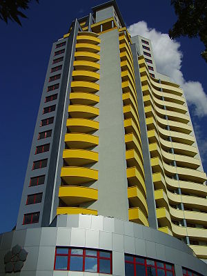
Glória (Bratislava)
High-rise building in Bratislava, Slovakia
Distance: Approx. 605 meters
Latitude and longitude: 48.1551,17.13846
Glória is a high-rise residential building located on the Záhradnícka Street in the Ružinov district of Bratislava, Slovakia. The construction stands at 100 metres (328 ft) tall with 29 floors and was built between 2004 and 2006.

Nivy
Neighborhood of Bratislava in Bratislava Region, Slovakia
Distance: Approx. 963 meters
Latitude and longitude: 48.15,17.13333333
Nivy (literally: Floodplains) is a neighborhood of the Ružinov borough of Bratislava, the capital of Slovakia, located in the Bratislava II district. At the end of the 19th century, the area underwent massive industrialization becoming the first industrial part of Bratislava. In the 1950s to 1970s, the area was redeveloped into a residential suburb.
Tehelné pole (1939)
Football stadium in Bratislava, Slovakia
Distance: Approx. 1385 meters
Latitude and longitude: 48.16355833,17.13685556
Tehelné pole was a neighborhood in Bratislava, Slovakia, characterized by the presence of several sports facilities. Administratively, the neighborhood belongs to Nové Mesto borough, situated around 5 km north-east of the centre. The German and Hungarian names for this locality are Ziegelfeld and Téglamező.

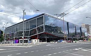
Nivy Station
Distance: Approx. 1436 meters
Latitude and longitude: 48.146723,17.128496
Nivy Station (Slovak: Stanica Nivy), also known as Nivy Centrum, Bus station Nivy (Slovak: Autobusová stanica Nivy), or simply Nivy, is a multifunctional building consisting of a bus station, a shopping center and a market on Mlynské nivy street in Nivy, Ružinov, a borough of Bratislava, Slovakia. The building is located on the site of the original Bratislava Central Bus Station, which was demolished at the end of 2017, and the tentative completion date was originally set for 2020. Due to the COVID-19 pandemic, the grand opening took place on 30 September 2021.
Central (shopping mall)
Shopping mall in Bratislava, Slovakia
Distance: Approx. 1293 meters
Latitude and longitude: 48.15722222,17.12972222
Central is a shopping centre (shopping mall and entertainment centre) in the Ružinov borough of Bratislava, Slovakia. It was the sixth major modern shopping centre built in Bratislava, Polus City Center being the first. It opened on 18 October 2012, and it is the eighth biggest shopping mall in Slovakia with total shopping space of 36,000 m2.

Gopass aréna
Arena in Bratislava, Slovakia
Distance: Approx. 1137 meters
Latitude and longitude: 48.1624,17.1414
Gopass arena (formerly known as Hala Pasienky, Hant Arena and Eurovia Arena) is a multi-use arena in Bratislava. The arena has distinct shape made of two crossing parabolic arches covered by a suspended rope structure.
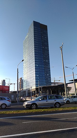
Nivy Tower
Skyscraper in Bratislava
Distance: Approx. 1352 meters
Latitude and longitude: 48.14606,17.13036
The Nivy Tower is a high-rise office skyscraper in Bratislava, Slovakia. Inaugurated in 2020, the building stands at 125 metres (410 ft) tall, being divided into 29 floors, and is the second tallest building in Bratislava and subsequently in Slovakia. The tower was the tallest building in Slovakia between 2020 and 2023, being succeeded by the Eurovea Tower.
Weather in this IP's area
clear sky
18 Celsius
18 Celsius
18 Celsius
18 Celsius
1011 hPa
56 %
1011 hPa
995 hPa
10000 meters
5.11 m/s
7.35 m/s
164 degree
7 %
06:59:21
18:18:42