Country:
 Switzerland
Region:
City:
Latitude and Longitude:
Time Zone:
Postal Code:
IP information under different IP Channel
ip-api
Country
Region
City
ASN
Time Zone
ISP
Blacklist
Proxy
Latitude
Longitude
Postal
Route
IPinfo
Country
Region
City
ASN
Time Zone
ISP
Blacklist
Proxy
Latitude
Longitude
Postal
Route
MaxMind
Country
Region
City
ASN
Time Zone
ISP
Blacklist
Proxy
Latitude
Longitude
Postal
Route
Luminati
Country
CHASN
Time Zone
Europe/Zurich
ISP
senseLAN GmbH
Latitude
Longitude
Postal
db-ip
Country
Region
City
ASN
Time Zone
ISP
Blacklist
Proxy
Latitude
Longitude
Postal
Route
ipdata
Country
Region
City
ASN
Time Zone
ISP
Blacklist
Proxy
Latitude
Longitude
Postal
Route
Popular places and events near this IP address

A1 motorway (Switzerland)
Motorway in Switzerland
Distance: Approx. 1654 meters
Latitude and longitude: 47.031437,7.527266
The A1 is a motorway in Switzerland. It follows Switzerland's main east–west axis, from St. Margrethen in northeastern Switzerland's canton of St.

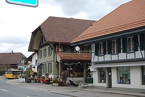
Jegenstorf
Municipality in Bern, Switzerland
Distance: Approx. 1931 meters
Latitude and longitude: 47.05,7.5
Jegenstorf is a municipality in the Bern-Mittelland administrative district in the canton of Bern in Switzerland. On 1 January 2010 the former municipality of Ballmoos merged into Jegenstorf and on 1 January 2014 Münchringen and Scheunen merged into Jegenstorf.

Mattstetten
Municipality in Bern, Switzerland
Distance: Approx. 1561 meters
Latitude and longitude: 47.03333333,7.51666667
Mattstetten is a municipality in the Bern-Mittelland administrative district in the canton of Bern in Switzerland.
Münchringen
Former municipality in Bern, Switzerland
Distance: Approx. 751 meters
Latitude and longitude: 47.05,7.51666667
Münchringen is a former municipality in the Bern-Mittelland administrative district in the canton of Bern in Switzerland. On 1 January 2014 the former municipalities of Münchringen and Scheunen merged into the municipality of Jegenstorf.

Urtenen-Schönbühl
Municipality in Bern, Switzerland
Distance: Approx. 2367 meters
Latitude and longitude: 47.03333333,7.5
Urtenen-Schönbühl is a municipality in the Bern-Mittelland administrative district in the canton of Bern in Switzerland.
Zauggenried
Former municipality in Bern, Switzerland
Distance: Approx. 2368 meters
Latitude and longitude: 47.06666667,7.53333333
Zauggenried is a former municipality in the Bern-Mittelland administrative district in the canton of Bern in Switzerland. On 1 January 2014 the former municipalities of Zauggenried, Büren zum Hof, Etzelkofen, Grafenried, Limpach, Mülchi and Schalunen merged into the municipality of Fraubrunnen.
Hindelbank
Municipality in Bern, Switzerland
Distance: Approx. 771 meters
Latitude and longitude: 47.05,7.53333333
Hindelbank is a municipality in the administrative district of Emmental in the canton of Bern in Switzerland. On 1 January 2021 the former municipality of Mötschwil merged into Hindelbank.
Kernenried
Municipality in Bern, Switzerland
Distance: Approx. 2972 meters
Latitude and longitude: 47.06666667,7.55
Kernenried is a municipality in the administrative district of Emmental in the canton of Bern in Switzerland.

Hindelbank Castle
Castle in Bern, Switzerland
Distance: Approx. 1891 meters
Latitude and longitude: 47.03333333,7.54111111
Hindelbank Castle is a castle in the municipality of Hindelbank of the Canton of Bern in Switzerland. It is a Swiss heritage site of national significance. It was sold to the canton in 1866 and later became a workhouse and a prison.
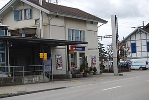
Hindelbank railway station
Railway station in Hindelbank, Switzerland
Distance: Approx. 1604 meters
Latitude and longitude: 47.04955694,7.54540806
Hindelbank railway station (German: Bahnhof Hindelbank) is a railway station in the municipality of Hindelbank, in the Swiss canton of Bern. It is an intermediate stop on the standard gauge Olten–Bern line of Swiss Federal Railways.

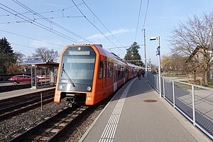
Urtenen railway station
Railway station in Urtenen-Schönbühl, Switzerland
Distance: Approx. 2637 meters
Latitude and longitude: 47.02888889,7.50111111
Urtenen railway station (German: Bahnhof Urtenen) is a railway station in the municipality of Urtenen-Schönbühl, in the Swiss canton of Bern. It is an intermediate stop on the 1,000 mm (3 ft 3+3⁄8 in) gauge Solothurn–Worblaufen line of Regionalverkehr Bern-Solothurn.
Jegenstorf railway station
Railway station in Jegenstorf, Switzerland
Distance: Approx. 1290 meters
Latitude and longitude: 47.04805556,7.50805556
Jegenstorf railway station (German: Bahnhof Jegenstorf) is a railway station in the municipality of Jegenstorf, in the Swiss canton of Bern. It is an intermediate stop on the 1,000 mm (3 ft 3+3⁄8 in) gauge Solothurn–Worblaufen line of Regionalverkehr Bern-Solothurn.
Weather in this IP's area
moderate rain
12 Celsius
12 Celsius
11 Celsius
15 Celsius
1019 hPa
93 %
1019 hPa
959 hPa
8000 meters
1.03 m/s
220 degree
75 %
07:48:08
18:42:44