Country:
Region:
City:
Latitude and Longitude:
Time Zone:
Postal Code:
IP information under different IP Channel
ip-api
Country
Region
City
ASN
Time Zone
ISP
Blacklist
Proxy
Latitude
Longitude
Postal
Route
Luminati
Country
ASN
Time Zone
Europe/Berlin
ISP
Telefonbuch Verlag Hans Mueller GmbH & Co. KG
Latitude
Longitude
Postal
IPinfo
Country
Region
City
ASN
Time Zone
ISP
Blacklist
Proxy
Latitude
Longitude
Postal
Route
db-ip
Country
Region
City
ASN
Time Zone
ISP
Blacklist
Proxy
Latitude
Longitude
Postal
Route
ipdata
Country
Region
City
ASN
Time Zone
ISP
Blacklist
Proxy
Latitude
Longitude
Postal
Route
Popular places and events near this IP address

Nuremberg Castle
Group of medieval fortified buildings in Nuremberg, Bavaria, Germany
Distance: Approx. 1813 meters
Latitude and longitude: 49.45777778,11.07583333
Nuremberg Castle (German: Nürnberger Burg) is a group of medieval fortified buildings on a sandstone ridge dominating the historical center of Nuremberg in Bavaria, Germany. The castle, together with the city walls, is considered to be one of Europe's most formidable medieval fortifications. It represented the power and importance of the Holy Roman Empire and the outstanding role of the Imperial City of Nuremberg.

Maxfeld station
Metro station in Nuremberg, Germany
Distance: Approx. 1821 meters
Latitude and longitude: 49.4633888,11.0851996
Maxfeld station is a Nuremberg U-Bahn station, located on the U3.

Friedrich-Ebert-Platz station
Metro station in Nuremberg, Germany
Distance: Approx. 1184 meters
Latitude and longitude: 49.4626295,11.0713496
Friedrich-Ebert-Platz station is a Nuremberg U-Bahn station. It was the northern terminus of the U3 line from its opening on 10 December 2011 until 2017, when the extension towards Nordwestring opened. It offers interchange to Tramway line 4.

St. Sebaldus Church, Nuremberg
Church in Nuremberg, Germany
Distance: Approx. 2079 meters
Latitude and longitude: 49.45527778,11.07638889
St. Sebaldus Church (St. Sebald, Sebalduskirche) is a medieval church in Nuremberg, Germany.

Kaulbachplatz station
Metro station in Nuremberg, Germany
Distance: Approx. 1438 meters
Latitude and longitude: 49.4633594,11.0785377
Kaulbachplatz station is a Nuremberg U-Bahn station, located on the U3.

Leopold Einstein
Distance: Approx. 1987 meters
Latitude and longitude: 49.45543056,11.07373889
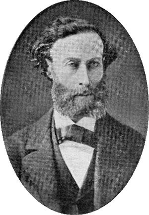
Leopold Einstein (born Leopold Löb, 1833, died 8 September 1890 in Nuremberg) was a Jewish teacher, vendor, and writer. He was one of the early proponents of Esperanto. He was the first chairperson of the "Nürnberger Weltspracheverein", a Volapük organization founded on 18 February 1885, and remained chairperson until his resignation due to poor health on 22 February 1888.

Albrecht Dürer's House
Biographical museum in Nuremberg
Distance: Approx. 1807 meters
Latitude and longitude: 49.45722222,11.07388889
Albrecht Dürer's House (German: Albrecht-Dürer-Haus) is a Nuremberg Fachwerkhaus that was the home of German Renaissance artist Albrecht Dürer from 1509 to his death in 1528. The House lies in the extreme north-west of Nuremberg's Altstadt, near the Kaiserburg section of the Nuremberg Castle and the Tiergärtnertor of Nuremberg's city walls. The house was built around 1420.

Historischer Kunstbunker
Distance: Approx. 1906 meters
Latitude and longitude: 49.4567,11.0754
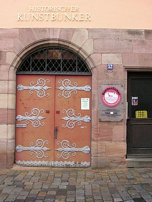
The Historische Kunstbunker (Historic art bunker) is a tunnel complex under Nuremberg Castle in the old city of Nuremberg, southern Germany. It forms part of the Nuremberg Historic Mile. In the Middle Ages, a network of rock passages was built in the hard sandstone of the castle.
Tucher Brewery
Since 1672, a brewery founded in Nuremberg, Germany
Distance: Approx. 1663 meters
Latitude and longitude: 49.46472222,11.08388889
Tucher is a brewery and beer brand based in Fürth and Nuremberg, Germany. It was founded in Nuremberg in 1672. It is owned by the Radeberger Group, a division of the Oetker Group.

Klinikum Nord station
Metro station in Nuremberg, Germany
Distance: Approx. 903 meters
Latitude and longitude: 49.464,11.0646
Klinikum Nord station is a Nuremberg U-Bahn station which opened on 22 May 2017 and serves the line U3.

Nordwestring station
Metro station in Nuremberg, Germany
Distance: Approx. 965 meters
Latitude and longitude: 49.4657,11.0549
Nordwestring station is a Nuremberg U-Bahn station. It is the northern terminus of the U3 line and opened on 22 May 2017.

Toplerhaus
Historic building in Nuremberg, Middle Franconia, Germany
Distance: Approx. 1901 meters
Latitude and longitude: 49.45813611,11.07901944
The Toplerhaus was an important Renaissance town house in the German city of Nuremberg. It was named after the patrician family Topler and was among the most elaborate of the late Renaissance residencies in the city.
Weather in this IP's area
overcast clouds
7 Celsius
5 Celsius
5 Celsius
7 Celsius
1019 hPa
82 %
1019 hPa
981 hPa
10000 meters
2.57 m/s
260 degree
100 %
07:28:54
16:32:30
